You are here: Home > Network List > NR - NARS Array Stations List
> Station NE79 San Jose del Cabo, Mexico > Earthquake Result Viewer
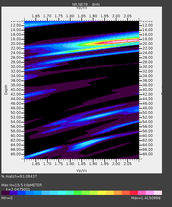
NE79 San Jose del Cabo, Mexico - Earthquake Result Viewer
| Earthquake location: |
Solomon Islands |
| Earthquake latitude/longitude: |
-10.5/160.8 |
| Earthquake time(UTC): |
2003/01/20 (020) 08:43:06 GMT |
| Earthquake Depth: |
33 km |
| Earthquake Magnitude: |
6.7 MB, 7.8 MS, 7.3 MW, 7.2 MW |
| Earthquake Catalog/Contributor: |
WHDF/NEIC |
|
| Network: |
NR NARS Array |
| Station: |
NE79 San Jose del Cabo, Mexico |
| Lat/Lon: |
23.12 N/109.76 W |
| Elevation: |
225 m |
|
| Distance: |
93.6 deg |
| Az: |
67.278 deg |
| Baz: |
260.189 deg |
| Ray Param: |
0.04122321 |
| Estimated Moho Depth: |
18.5 km |
| Estimated Crust Vp/Vs: |
2.05 |
| Assumed Crust Vp: |
6.183 km/s |
| Estimated Crust Vs: |
3.02 km/s |
| Estimated Crust Poisson's Ratio: |
0.34 |
|
| Radial Match: |
93.09437 % |
| Radial Bump: |
400 |
| Transverse Match: |
81.72087 % |
| Transverse Bump: |
400 |
| SOD ConfigId: |
4714 |
| Insert Time: |
2010-03-09 12:46:51.264 +0000 |
| GWidth: |
2.5 |
| Max Bumps: |
400 |
| Tol: |
0.001 |
|

Signal To Noise
| Channel | StoN | STA | LTA |
| NR:NE79: :BHN:20030120T08:55:47.390007Z | 1.2574213 | 3.625937E-7 | 2.8836297E-7 |
| NR:NE79: :BHE:20030120T08:55:47.390007Z | 1.4706184 | 4.1081643E-7 | 2.7934945E-7 |
| NR:NE79: :BHZ:20030120T08:55:47.387993Z | 4.876967 | 1.818192E-6 | 3.7281205E-7 |
| Arrivals |
| Ps | 3.2 SECOND |
| PpPs | 9.0 SECOND |
| PsPs/PpSs | 12 SECOND |


