
Station NR NE79 - San Jose del Cabo, Mexico
Network: NR - NARS Array
Nearby stations (2 deg radius)
| Station | Name | (Lat, Lon) | Start / End | Elevation |
| NE79 | San Jose del Cabo, Mexico | (23.12, -109.76) | 2002-04-01 / 2499-01-01 | 225 m |
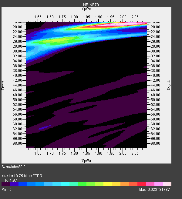
| Crust2 Type: | S1,continental slope, margin, transition 1 km seds. |
| Thickness Estimate: | 19 km |
| Thickness StdDev: | 3.0 km |
| Vp/Vs Estimate: | 1.97 |
| Vp/Vs StdDev: | 0.13 |
| Vs Estimate: | 3.138 km/s |
| Poisson's Ratio: | 0.33 |
| Peak Value: | 0.02 |
| Assumed Vp: | 6.183 km/s |
| Ps Weight: | 0.33333334 |
| PpPs Weight: | 0.33333334 |
| PsPs Weight: | 0.33333328 |
| Residual Complexity: | 0.612 |
| Nearby stations H: | +- |
| (2.0 deg) Vp/Vs: | +- |
7 with match > 90% ( 38.88889 %) and 17 with match > 80% ( 94.44444 %) out of 18.
Download stack as xyz text file.
Azimuth Distribution of Events:

Prior Results for this Station
| Study | Thickness | Vp/Vs | Vp | Vs | Poissons Ratio | Extra |
| EARS | 19 km | 1.97 | 6.183 km/s | 3.138 km/s | 0.33 | |
| Crust2.0 | 23 km | 1.81 | 6.183 km/s | 3.422 km/s | 0.28 | S1,continental slope, margin, transition 1 km seds. |
| Global Maxima | 19 km | 1.97 | 6.183 km/s | 3.138 km/s | 0.33 | amp=0.022731787 |
| Local Maxima 1 | 25 km | 1.73 | 6.183 km/s | 3.569 km/s | 0.25 | amp=0.013350744 |
| Local Maxima 2 | 19 km | 2.04 | 6.183 km/s | 3.027 km/s | 0.34 | amp=0.0097465385 |
| Local Maxima 3 | 26 km | 1.80 | 6.183 km/s | 3.444 km/s | 0.27 | amp=0.008503013 |
| Local Maxima 4 | 31 km | 1.62 | 6.183 km/s | 3.828 km/s | 0.19 | amp=0.0034118437 |
| Predicted Arrivals for vertical incidence (zero ray parameter) | |
| Ps | 2.94 SECOND |
| PpPs | 9.01 SECOND |
| PsPs/PpSs | 11.95 SECOND |
Events Processed for this Station
Download zip of receiver functions as SAC
Plot maxima for each earthquake.
Events Used in the Stack
(17 events)| Radial Match | Distance | Baz | FERegion | Time | Lat/Lon | Depth | Magnitude |
| 97.51487 | 76.1 deg | 240.74 deg | Tonga Islands | 2006/05/03 15:26:40 GMT | (-20.2, -174.1) | 55 km | 7.2 MB, 7.8 MS, 7.9 MW, 7.9 MW |
| 95.177925 | 43.4 deg | 127.177 deg | Northern Peru | 2005/09/26 01:55:37 GMT | (-5.7, -76.4) | 115 km | 6.7 MB, 7.5 MW, 7.5 MW |
| 94.953224 | 47.5 deg | 338.175 deg | Central Alaska | 2002/11/03 22:12:41 GMT | (63.5, -147.4) | 4.9 km | 7.0 MB, 8.5 MS, 7.9 MW |
| 94.13373 | 36.5 deg | 336.224 deg | Queen Charlotte Islands Region | 2004/06/28 09:49:47 GMT | (54.8, -134.2) | 20 km | 5.9 MB, 6.8 MS, 6.8 MW, 6.8 MW |
| 93.47151 | 86.0 deg | 233.125 deg | Kermadec Islands Region | 2006/05/16 10:39:23 GMT | (-31.8, -179.3) | 152 km | 6.8 MB, 7.4 MW, 7.4 MW |
| 93.09437 | 93.6 deg | 260.189 deg | Solomon Islands | 2003/01/20 08:43:06 GMT | (-10.5, 160.8) | 33 km | 6.7 MB, 7.8 MS, 7.3 MW, 7.2 MW |
| 92.73236 | 66.8 deg | 328.175 deg | Eastern Siberia, Russia | 2006/04/20 23:25:02 GMT | (60.9, 167.1) | 22 km | 6.8 MB, 7.6 MS, 7.6 MW, 7.3 MW |
| 88.75035 | 65.2 deg | 143.71 deg | Near Coast Of Central Chile | 2002/06/18 13:56:22 GMT | (-30.8, -71.1) | 54 km | 6.0 MB, 6.6 MW, 6.4 MW |
| 86.41486 | 95.2 deg | 309.271 deg | Near S. Coast Of Honshu, Japan | 2004/09/05 14:57:18 GMT | (33.2, 137.1) | 10 km | 6.2 MB, 7.1 MS, 7.4 MW, 7.4 MW |
| 86.270775 | 77.4 deg | 247.267 deg | Fiji Islands Region | 2005/12/13 03:16:06 GMT | (-15.3, -178.6) | 10 km | 6.1 MB, 6.8 MS, 6.7 MW, 6.7 MW |
| 85.998886 | 93.5 deg | 320.849 deg | E. Russia-N.E. China Border Reg. | 2002/06/28 17:19:30 GMT | (43.8, 130.7) | 566 km | 6.7 MB, 7.3 MW, 7.3 MW |
| 83.40929 | 95.6 deg | 309.376 deg | Near S. Coast Of Western Honshu | 2004/09/05 10:07:07 GMT | (33.1, 136.6) | 14 km | 6.7 MB, 7.0 MS, 7.2 MW, 7.0 MW |
| 83.10139 | 82.1 deg | 318.694 deg | Northwest Of Kuril Islands | 2002/11/17 04:53:53 GMT | (47.8, 146.2) | 459 km | 7.3 MW, 7.3 MW |
| 82.31478 | 74.5 deg | 243.741 deg | Tonga Islands | 2004/01/25 11:43:11 GMT | (-16.8, -174.2) | 130 km | 6.4 MB, 6.7 MW, 6.7 MW |
| 82.110275 | 79.3 deg | 242.938 deg | Fiji Islands Region | 2006/01/02 22:13:40 GMT | (-19.9, -178.2) | 583 km | 6.5 MB, 7.2 MW, 7.1 MW |
| 81.17922 | 48.6 deg | 125.597 deg | Western Brazil | 2002/10/12 20:09:11 GMT | (-8.3, -71.7) | 534 km | 6.5 MB, 6.9 MW, 6.9 MW |
| 80.84623 | 98.0 deg | 268.467 deg | New Ireland Region, P.N.G. | 2005/09/09 07:26:43 GMT | (-4.5, 153.5) | 90 km | 6.3 MB, 7.7 MW, 7.5 MW |
Losers
(1 events)| Radial Match | Distance | Baz | FERegion | Time | Lat/Lon | Depth | Magnitude | Reason |
| 83.267044 | 78.5 deg | 245.171 deg | Fiji Islands Region | 2004/07/15 04:27:12 GMT | (-17.6, -178.6) | 560 km | 5.5 MB |
