You are here: Home > Network List > IC - New China Digital Seismograph Network Stations List
> Station HIA Hailar, Neimenggu Autonomous Region, China > Earthquake Result Viewer
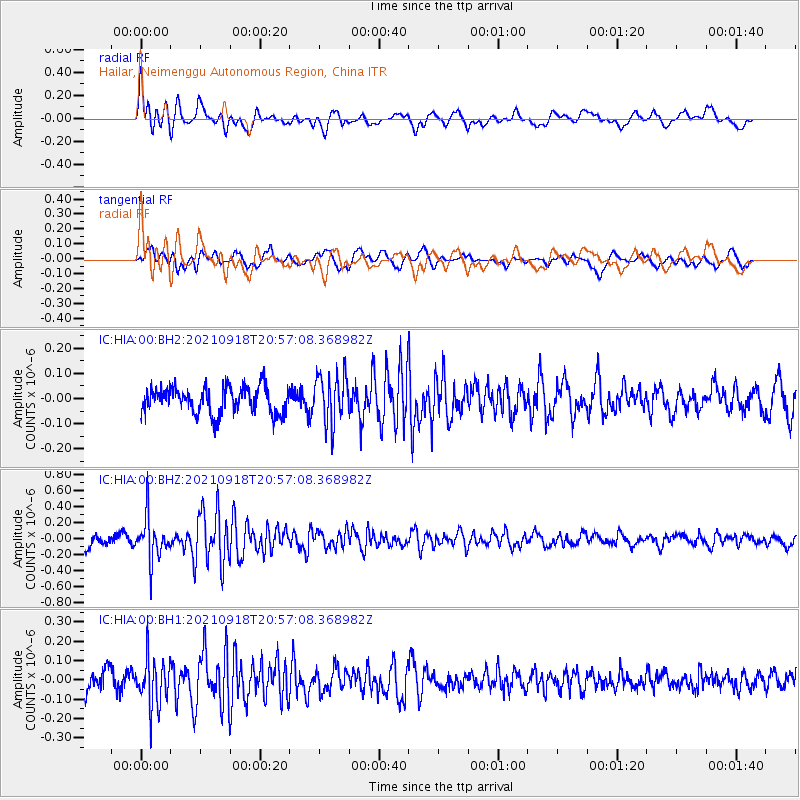
HIA Hailar, Neimenggu Autonomous Region, China - Earthquake Result Viewer
*The percent match for this event was below the threshold and hence no stack was calculated.
| Earthquake location: |
Eastern New Guinea Reg., P.N.G. |
| Earthquake latitude/longitude: |
-9.8/148.6 |
| Earthquake time(UTC): |
2021/09/18 (261) 20:47:06 GMT |
| Earthquake Depth: |
15 km |
| Earthquake Magnitude: |
5.3 Mww |
| Earthquake Catalog/Contributor: |
NEIC PDE/us |
|
| Network: |
IC New China Digital Seismograph Network |
| Station: |
HIA Hailar, Neimenggu Autonomous Region, China |
| Lat/Lon: |
49.27 N/119.74 E |
| Elevation: |
620 m |
|
| Distance: |
64.0 deg |
| Az: |
339.433 deg |
| Baz: |
148.087 deg |
| Ray Param: |
$rayparam |
*The percent match for this event was below the threshold and hence was not used in the summary stack. |
|
| Radial Match: |
68.82787 % |
| Radial Bump: |
400 |
| Transverse Match: |
50.81712 % |
| Transverse Bump: |
400 |
| SOD ConfigId: |
25131211 |
| Insert Time: |
2021-10-02 20:53:43.650 +0000 |
| GWidth: |
2.5 |
| Max Bumps: |
400 |
| Tol: |
0.001 |
|
Signal To Noise
| Channel | StoN | STA | LTA |
| IC:HIA:00:BHZ:20210918T20:57:08.368982Z | 3.56201 | 2.7114464E-7 | 7.6121246E-8 |
| IC:HIA:00:BH1:20210918T20:57:08.368982Z | 2.2072966 | 1.2868823E-7 | 5.830128E-8 |
| IC:HIA:00:BH2:20210918T20:57:08.368982Z | 1.8512834 | 9.8175555E-8 | 5.3031076E-8 |
| Arrivals |
| Ps | |
| PpPs | |
| PsPs/PpSs | |


