You are here: Home > Network List > NR - NARS Array Stations List
> Station NE85 La Paz, Mexico > Earthquake Result Viewer
NE85 La Paz, Mexico - Earthquake Result Viewer
| Earthquake location: |
Kuril Islands |
| Earthquake latitude/longitude: |
46.5/153.2 |
| Earthquake time(UTC): |
2006/10/01 (274) 09:06:02 GMT |
| Earthquake Depth: |
19 km |
| Earthquake Magnitude: |
6.1 MB, 6.4 MS, 6.6 MW, 6.5 MW |
| Earthquake Catalog/Contributor: |
WHDF/NEIC |
|
| Network: |
NR NARS Array |
| Station: |
NE85 La Paz, Mexico |
| Lat/Lon: |
24.13 N/110.44 W |
| Elevation: |
-12.0 m |
|
| Distance: |
77.0 deg |
| Az: |
68.719 deg |
| Baz: |
315.178 deg |
| Ray Param: |
0.050572608 |
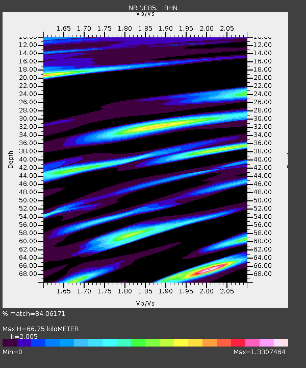
| Estimated Moho Depth: |
66.75 km |
| Estimated Crust Vp/Vs: |
2.01 |
| Assumed Crust Vp: |
6.182 km/s |
| Estimated Crust Vs: |
3.083 km/s |
| Estimated Crust Poisson's Ratio: |
0.33 |
|
| Radial Match: |
84.06171 % |
| Radial Bump: |
400 |
| Transverse Match: |
87.35291 % |
| Transverse Bump: |
400 |
| SOD ConfigId: |
2564 |
| Insert Time: |
2010-03-09 12:51:04.670 +0000 |
| GWidth: |
2.5 |
| Max Bumps: |
400 |
| Tol: |
0.001 |
|

Signal To Noise
| Channel | StoN | STA | LTA |
| NR:NE85: :BHN:20061001T09:17:22.713005Z | 1.817371 | 8.783756E-7 | 4.833221E-7 |
| NR:NE85: :BHE:20061001T09:17:22.713005Z | 1.500355 | 5.406796E-7 | 3.6036775E-7 |
| NR:NE85: :BHZ:20061001T09:17:22.713005Z | 3.2682707 | 8.199623E-7 | 2.5088568E-7 |
| Arrivals |
| Ps | 11 SECOND |
| PpPs | 32 SECOND |
| PsPs/PpSs | 43 SECOND |


