
Station NR NE85 - La Paz, Mexico
Network: NR - NARS Array
Nearby stations (2 deg radius)
| Station | Name | (Lat, Lon) | Start / End | Elevation |
| NE85 | La Paz, Mexico | (24.13, -110.44) | 2002-04-01 / 2499-01-01 | -0.0 km |
| Crust2 Type: | M3,extended crust, 1.5 km seds. |
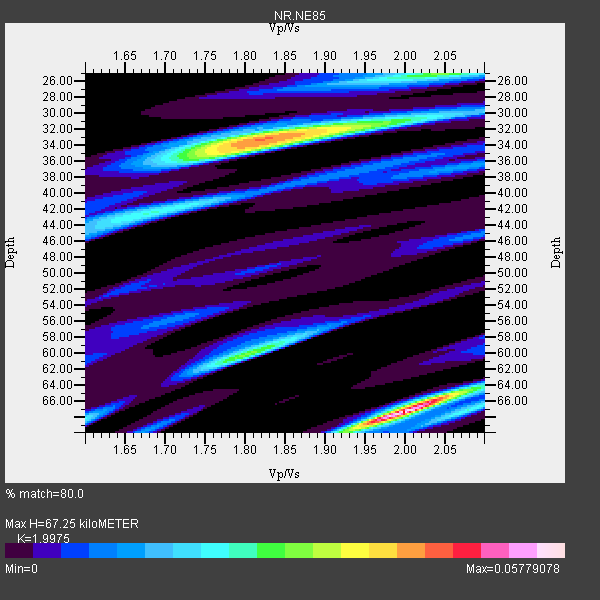
| Thickness Estimate: | 67 km |
| Thickness StdDev: | 9.6 km |
| Vp/Vs Estimate: | 2.00 |
| Vp/Vs StdDev: | 0.08 |
| Vs Estimate: | 3.095 km/s |
| Poisson's Ratio: | 0.33 |
| Peak Value: | 0.06 |
| Assumed Vp: | 6.182 km/s |
| Ps Weight: | 0.33333334 |
| PpPs Weight: | 0.33333334 |
| PsPs Weight: | 0.33333328 |
| Residual Complexity: | 0.882 |
| Nearby stations H: | +- |
| (2.0 deg) Vp/Vs: | +- |
2 with match > 90% ( 9.523809 %) and 3 with match > 80% ( 14.285714 %) out of 21.
Download stack as xyz text file.
Azimuth Distribution of Events:

Prior Results for this Station
| Study | Thickness | Vp/Vs | Vp | Vs | Poissons Ratio | Extra |
| EARS | 67 km | 2.00 | 6.182 km/s | 3.095 km/s | 0.33 | |
| Crust2.0 | 31 km | 1.78 | 6.182 km/s | 3.474 km/s | 0.27 | M3,extended crust, 1.5 km seds. |
| Global Maxima | 67 km | 2.00 | 6.182 km/s | 3.095 km/s | 0.33 | amp=0.05779078 |
| Local Maxima 1 | 33 km | 1.83 | 6.182 km/s | 3.378 km/s | 0.29 | amp=0.043537043 |
| Local Maxima 2 | 60 km | 1.80 | 6.182 km/s | 3.43 km/s | 0.28 | amp=0.029700503 |
| Local Maxima 3 | 25 km | 2.04 | 6.182 km/s | 3.031 km/s | 0.34 | amp=0.029137237 |
| Local Maxima 4 | 42 km | 1.70 | 6.182 km/s | 3.637 km/s | 0.24 | amp=0.02221876 |
| Predicted Arrivals for vertical incidence (zero ray parameter) | |
| Ps | 10.85 SECOND |
| PpPs | 32.61 SECOND |
| PsPs/PpSs | 43.46 SECOND |
Events Processed for this Station
Download zip of receiver functions as SAC
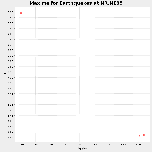
Plot maxima for each earthquake.
Events Used in the Stack
(3 events)| Radial Match | Distance | Baz | FERegion | Time | Lat/Lon | Depth | Magnitude |
| 91.069466 | 87.7 deg | 312.874 deg | Eastern Honshu, Japan | 2008/07/23 15:26:19 GMT | (39.8, 141.5) | 108 km | 6.6 MB, 6.8 MW, 6.8 MW |
| 90.05331 | 72.5 deg | 242.199 deg | Samoa Islands Region | 2006/09/28 06:22:09 GMT | (-16.6, -172.0) | 28 km | 6.5 MB, 6.6 MS, 6.9 MW, 6.7 MW |
| 84.06171 | 77.0 deg | 315.178 deg | Kuril Islands | 2006/10/01 09:06:02 GMT | (46.5, 153.2) | 19 km | 6.1 MB, 6.4 MS, 6.6 MW, 6.5 MW |
Losers
(18 events)| Radial Match | Distance | Baz | FERegion | Time | Lat/Lon | Depth | Magnitude | Reason |
| 88.6346 | 83.9 deg | 233.755 deg | Kermadec Islands, New Zealand | 2008/09/29 15:19:31 GMT | (-29.8, -177.7) | 36 km | 6.5 MB, 6.7 MS, 7.0 MW, 7.0 MW | |
| 87.82431 | 58.5 deg | 317.247 deg | Andreanof Islands, Aleutian Is. | 2008/04/15 22:59:51 GMT | (51.9, -179.4) | 10 km | 6.1 MB, 6.4 MS, 6.4 MW, 6.4 MW | |
| 77.62487 | 89.9 deg | 248.152 deg | Vanuatu Islands | 2008/04/28 18:33:34 GMT | (-19.9, 169.0) | 32 km | 6.2 MB, 6.2 MS, 6.4 MW, 6.4 MW | |
| 73.10685 | 77.2 deg | 244.282 deg | Fiji Islands Region | 2008/07/19 22:39:52 GMT | (-17.3, -177.3) | 391 km | 5.9 MB, 6.4 MW, 6.4 MW | |
| 72.64888 | 72.8 deg | 318.596 deg | Kuril Islands | 2008/07/24 01:43:16 GMT | (51.0, 157.6) | 27 km | 6.0 MB, 6.0 MS, 6.2 MW, 6.2 MW | |
| 70.271935 | 79.4 deg | 245.113 deg | Fiji Islands Region | 2008/06/15 01:13:11 GMT | (-17.7, -179.7) | 611 km | 5.5 MB, 5.9 MW, 5.9 MW | |
| 69.85699 | 58.1 deg | 317.632 deg | Andreanof Islands, Aleutian Is. | 2008/03/22 21:24:11 GMT | (52.2, -178.7) | 132 km | 5.8 MB, 6.2 MW, 6.1 MW | |
| 69.45849 | 58.4 deg | 317.276 deg | Andreanof Islands, Aleutian Is. | 2008/04/16 05:54:19 GMT | (51.9, -179.2) | 13 km | 6.1 MB, 6.5 MS, 6.6 MW, 6.6 MW | |
| 67.66306 | 47.3 deg | 127.421 deg | Peru-Brazil Border Region | 2008/08/26 21:00:36 GMT | (-7.6, -74.4) | 154 km | 6.0 MB, 6.4 MW, 6.4 MW | |
| 64.92568 | 88.8 deg | 254.754 deg | Vanuatu Islands | 2008/09/08 18:52:06 GMT | (-13.5, 167.0) | 110 km | 6.4 MB, 6.9 MW, 6.9 MW | |
| 62.230034 | 72.8 deg | 244.3 deg | Tonga Islands | 2008/08/19 16:30:13 GMT | (-15.1, -173.5) | 8.0 km | 5.6 MB, 5.9 MS, 6.1 MW, 6.0 MW | |
| 58.041824 | 78.6 deg | 245.116 deg | Fiji Islands Region | 2008/04/18 20:39:07 GMT | (-17.3, -179.0) | 554 km | 5.9 MB, 6.3 MW, 6.3 MW | |
| 57.72561 | 92.7 deg | 259.765 deg | Solomon Islands | 2008/06/03 16:20:50 GMT | (-10.5, 161.3) | 84 km | 6.2 MB, 6.2 MW, 6.2 MW | |
| 55.75991 | 56.2 deg | 317.739 deg | Andreanof Islands, Aleutian Is. | 2008/08/07 18:30:03 GMT | (52.2, -175.7) | 12 km | 5.6 MB, 5.5 MS, 5.8 MW, 5.8 MW | |
| 50.45933 | 62.4 deg | 130.907 deg | Southern Bolivia | 2008/10/12 20:55:41 GMT | (-20.1, -65.0) | 353 km | 6.0 MB, 6.2 MW, 6.2 MW | |
| 49.24389 | 91.1 deg | 258.969 deg | Solomon Islands | 2008/07/28 21:40:47 GMT | (-10.6, 163.1) | 10 km | 5.9 MB, 5.8 MS, 6.0 MW | |
| 47.52059 | 59.7 deg | 133.826 deg | Chile-Bolivia Border Region | 2008/03/24 20:39:07 GMT | (-20.0, -69.0) | 120 km | 5.7 MB, 6.2 MW, 6.1 MW | |
| 39.54442 | 59.5 deg | 316.584 deg | Rat Islands, Aleutian Islands | 2008/07/25 00:29:22 GMT | (51.3, 179.0) | 21 km | 5.7 MB, 5.5 MS, 5.9 MW, 5.9 MW |
