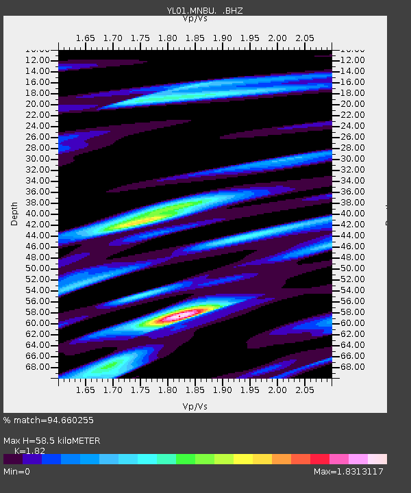
MNBU YL.MNBU - Earthquake Result Viewer
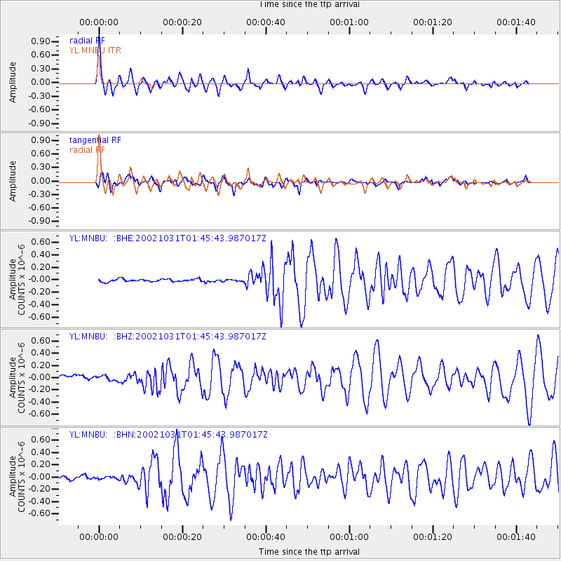
Earthquake location: Bismarck Sea
Earthquake latitude/longitude: -3.4/148.6
Earthquake time(UTC): 2002/10/31 (304) 01:35:16 GMT
Earthquake Depth: 10 km
Earthquake Magnitude: 5.3 MB, 6.0 MS, 6.1 MW, 6.0 MW
Earthquake Catalog/Contributor: WHDF/NEIC
Network: YL Himalayan Nepal Tibet Experiment
Station: MNBU YL.MNBU
Lat/Lon: 28.76 N/86.16 E
Elevation: 4500 m
Distance: 67.9 deg
Az: 302.806 deg
Baz: 107.146 deg
Ray Param: 0.056665923
Estimated Moho Depth: 58.5 km
Estimated Crust Vp/Vs: 1.82
Assumed Crust Vp: 6.514 km/s
Estimated Crust Vs: 3.579 km/s
Estimated Crust Poisson's Ratio: 0.28
Radial Match: 94.660255 %
Radial Bump: 400
Transverse Match: 93.85405 %
Transverse Bump: 400
SOD ConfigId: 16820
Insert Time: 2010-02-26 15:59:52.869 +0000
GWidth: 2.5
Max Bumps: 400
Tol: 0.001

Signal To Noise

ChannelStoNSTALTA
YL:MNBU: :BHZ:20021031T01:45:43.987017Z1.0264494.0685986E-83.9637612E-8
YL:MNBU: :BHN:20021031T01:45:43.987017Z0.83733752.2835524E-82.7271588E-8
YL:MNBU: :BHE:20021031T01:45:43.987017Z0.631677451.3728431E-82.1733292E-8
Arrivals
Ps7.7 SECOND
PpPs24 SECOND
PsPs/PpSs32 SECOND