
Station YL MNBU - YL.MNBU
Network: YL01 - Himalayan Nepal Tibet Experiment
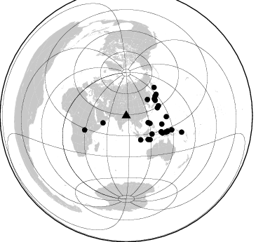
Nearby stations (2 deg radius)
| Station | Name | (Lat, Lon) | Start / End | Elevation |
| MNBU | YL.MNBU | (28.76, 86.16) | 2001-09-07 / 2003-01-01 | 4500 m |
| Crust2 Type: | RD,orogen/70km Tibet, no seds. |
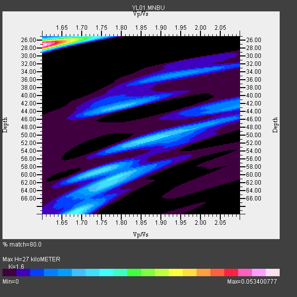
| Thickness Estimate: | 27 km |
| Thickness StdDev: | 4.8 km |
| Vp/Vs Estimate: | 1.60 |
| Vp/Vs StdDev: | 0.03 |
| Vs Estimate: | 4.071 km/s |
| Poisson's Ratio: | 0.18 |
| Peak Value: | 0.05 |
| Assumed Vp: | 6.514 km/s |
| Ps Weight: | 0.33333334 |
| PpPs Weight: | 0.33333334 |
| PsPs Weight: | 0.33333328 |
| Residual Complexity: | 0.784 |
| Nearby stations H: | +- |
| (2.0 deg) Vp/Vs: | +- |
13 with match > 90% ( 38.235294 %) and 28 with match > 80% ( 82.35294 %) out of 34.
Download stack as xyz text file.
Azimuth Distribution of Events:
Prior Results for this Station
| Study | Thickness | Vp/Vs | Vp | Vs | Poissons Ratio | Extra |
| EARS | 27 km | 1.60 | 6.514 km/s | 4.071 km/s | 0.18 | |
| Crust2.0 | 70 km | 1.76 | 6.514 km/s | 3.706 km/s | 0.26 | RD,orogen/70km Tibet, no seds. |
| Global Maxima | 27 km | 1.60 | 6.514 km/s | 4.071 km/s | 0.18 | amp=0.053400777 |
| Local Maxima 1 | 70 km | 1.68 | 6.514 km/s | 3.889 km/s | 0.22 | amp=0.021418178 |
| Local Maxima 2 | 59 km | 1.74 | 6.514 km/s | 3.744 km/s | 0.25 | amp=0.017581157 |
| Local Maxima 3 | 60 km | 1.79 | 6.514 km/s | 3.644 km/s | 0.27 | amp=0.017046547 |
| Local Maxima 4 | 43 km | 1.79 | 6.514 km/s | 3.634 km/s | 0.27 | amp=0.0152324615 |
| Predicted Arrivals for vertical incidence (zero ray parameter) | |
| Ps | 2.49 SECOND |
| PpPs | 10.78 SECOND |
| PsPs/PpSs | 13.26 SECOND |
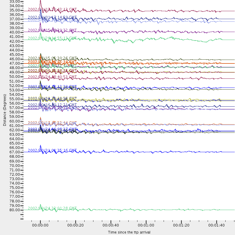
Events Processed for this Station
Download zip of receiver functions as SAC
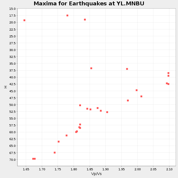
Plot maxima for each earthquake.
Events Used in the Stack
(28 events)| Radial Match | Distance | Baz | FERegion | Time | Lat/Lon | Depth | Magnitude |
| 97.85727 | 63.1 deg | 110.482 deg | Near N Coast Of New Guinea, P.N.G. | 2002/09/08 18:44:23 GMT | (-3.3, 142.9) | 13 km | 6.5 MB, 7.8 MS, 7.6 MW, 7.3 MW |
| 94.660255 | 67.9 deg | 107.146 deg | Bismarck Sea | 2002/10/31 01:35:16 GMT | (-3.4, 148.6) | 10 km | 5.3 MB, 6.0 MS, 6.1 MW, 6.0 MW |
| 94.61059 | 61.0 deg | 112.519 deg | Irian Jaya, Indonesia | 2002/10/17 17:52:44 GMT | (-3.6, 140.2) | 33 km | 5.6 MB, 6.2 MS, 6.3 MW, 6.3 MW |
| 93.94844 | 55.2 deg | 114.929 deg | Irian Jaya Region, Indonesia | 2002/10/10 10:50:20 GMT | (-1.8, 134.3) | 10 km | 6.5 MB, 7.7 MS, 7.6 MW, 7.4 MW |
| 93.900246 | 48.1 deg | 134.899 deg | Sumbawa Region, Indonesia | 2002/10/06 15:46:33 GMT | (-8.2, 118.3) | 10 km | 5.8 MB, 6.0 MS, 6.2 MW, 6.2 MW |
| 93.52269 | 45.8 deg | 75.925 deg | Southeast Of Honshu, Japan | 2002/08/02 23:11:39 GMT | (29.3, 139.0) | 426 km | 5.5 MB, 6.3 MW, 6.3 MW |
| 93.37298 | 57.2 deg | 91.318 deg | Mariana Islands | 2002/08/14 13:57:52 GMT | (14.1, 146.2) | 30 km | 6.1 MB, 6.4 MS, 6.5 MW, 6.4 MW |
| 92.56638 | 48.0 deg | 72.88 deg | Southeast Of Honshu, Japan | 2002/08/20 10:59:32 GMT | (31.0, 142.0) | 9.0 km | 5.4 MB, 6.2 MS, 6.3 MW, 6.1 MW |
| 91.29044 | 54.9 deg | 114.797 deg | Irian Jaya Region, Indonesia | 2002/10/10 21:19:58 GMT | (-1.5, 134.1) | 10 km | 5.8 MB, 5.7 MS, 6.0 MW |
| 91.0394 | 62.9 deg | 110.661 deg | Near N Coast Of New Guinea, P.N.G. | 2002/09/16 13:23:00 GMT | (-3.3, 142.7) | 10 km | 5.9 MB, 5.9 MS, 6.3 MW, 6.1 MW |
| 90.60603 | 35.5 deg | 107.959 deg | Mindoro, Philippines | 2002/09/03 14:23:45 GMT | (13.5, 120.8) | 10 km | 5.5 MB, 5.4 MS, 5.9 MW, 5.8 MW |
| 90.13381 | 55.1 deg | 114.901 deg | Irian Jaya Region, Indonesia | 2002/09/20 15:43:35 GMT | (-1.7, 134.2) | 10 km | 5.9 MB, 6.4 MS, 6.4 MW, 6.3 MW |
| 90.11657 | 52.0 deg | 103.306 deg | W. Caroline Islands, Micronesia | 2002/08/14 13:12:39 GMT | (7.8, 136.9) | 10 km | 6.1 MB, 6.0 MS, 6.3 MW, 6.3 MW |
| 89.523476 | 57.3 deg | 115.291 deg | Irian Jaya Region, Indonesia | 2002/08/24 20:21:29 GMT | (-3.3, 135.8) | 33 km | 5.5 MB, 5.5 MS, 5.8 MW, 5.7 MW |
| 89.30323 | 52.3 deg | 54.513 deg | Kuril Islands | 2002/10/19 12:09:05 GMT | (44.3, 150.0) | 33 km | 5.4 MB, 6.2 MS, 6.4 MW, 6.1 MW |
| 87.9445 | 82.3 deg | 106.571 deg | Solomon Islands | 2002/09/24 23:01:28 GMT | (-10.6, 161.2) | 19 km | 5.7 MB, 6.5 MS, 6.3 MW, 6.3 MW |
| 87.33839 | 32.8 deg | 107.54 deg | Philippine Islands Region | 2002/10/12 23:43:12 GMT | (15.1, 118.5) | 33 km | 5.6 MB, 5.6 MS, 6.1 MW |
| 86.8106 | 61.1 deg | 112.527 deg | Irian Jaya, Indonesia | 2002/10/19 00:43:56 GMT | (-3.7, 140.3) | 33 km | 5.3 MB, 5.9 MS, 6.1 MW, 6.0 MW |
| 86.56634 | 45.9 deg | 137.198 deg | Bali Sea | 2002/10/03 19:05:10 GMT | (-7.5, 115.7) | 316 km | 6.0 MB, 6.0 MW, 6.0 MW |
| 86.31704 | 46.8 deg | 62.29 deg | Near East Coast Of Honshu, Japan | 2002/11/03 03:37:42 GMT | (38.9, 142.0) | 39 km | 5.7 MB, 6.1 MS, 6.4 MW, 6.4 MW |
| 85.193825 | 46.9 deg | 59.145 deg | Hokkaido, Japan Region | 2002/10/14 14:12:43 GMT | (41.2, 142.2) | 61 km | 5.9 MB, 6.1 MW, 6.1 MW |
| 84.20204 | 45.0 deg | 125.404 deg | Sulawesi, Indonesia | 2002/08/15 05:30:26 GMT | (-1.2, 121.3) | 10 km | 5.7 MB, 5.8 MS, 6.2 MW, 6.1 MW |
| 82.95771 | 34.8 deg | 252.833 deg | Eastern Gulf Of Aden | 2002/09/01 17:14:59 GMT | (14.3, 51.9) | 10 km | 5.8 MS, 5.2 MB, 6.0 MW, 6.0 MW |
| 82.795105 | 49.6 deg | 56.322 deg | Kuril Islands | 2002/08/24 18:40:53 GMT | (43.1, 146.1) | 43 km | 5.9 MB, 5.8 MS, 6.2 MW, 6.1 MW |
| 82.25199 | 40.0 deg | 148.886 deg | Sunda Strait, Indonesia | 2002/08/26 14:55:13 GMT | (-6.8, 105.7) | 63 km | 5.6 MB, 5.8 MW, 5.7 MW |
| 81.688385 | 56.5 deg | 44.597 deg | Near East Coast Of Kamchatka | 2002/10/16 10:12:21 GMT | (52.0, 157.3) | 102 km | 6.1 MB, 6.2 MW, 6.2 MW |
| 80.643196 | 62.6 deg | 251.063 deg | Lake Tanganyika Region | 2002/10/24 06:08:37 GMT | (-1.9, 29.0) | 11 km | 5.9 MB, 6.3 MS, 6.2 MW, 6.1 MW |
| 80.23656 | 38.0 deg | 52.988 deg | Northeastern China | 2002/09/15 08:39:32 GMT | (44.8, 129.9) | 586 km | 5.8 MB, 6.4 MW, 6.4 MW |
Losers
(6 events)| Radial Match | Distance | Baz | FERegion | Time | Lat/Lon | Depth | Magnitude | Reason |
| 82.40971 | 82.6 deg | 106.736 deg | Solomon Islands | 2002/10/03 04:26:06 GMT | (-11.0, 161.4) | 10 km | 5.6 MB, 5.6 MS, 5.9 MW, 5.7 MW | |
| 67.59051 | 32.3 deg | 87.775 deg | Taiwan Region | 2002/09/16 00:03:29 GMT | (25.2, 122.3) | 183 km | 5.6 MW, 5.3 MB, 5.5 MW | |
| 67.25289 | 70.5 deg | 178.247 deg | Southeast Indian Ridge | 2002/10/08 01:23:58 GMT | (-42.0, 88.4) | 10 km | 5.3 MB, 5.7 MS, 6.0 MW, 5.9 MW | |
| 58.489563 | 58.1 deg | 303.461 deg | Southern Italy | 2002/10/31 10:32:58 GMT | (41.8, 14.9) | 10 km | 5.3 MB, 5.6 MS, 5.9 MW, 5.7 MW | |
| 49.08388 | 55.1 deg | 122.447 deg | Banda Sea | 2002/07/30 20:02:06 GMT | (-6.5, 130.3) | 103 km | 5.5 MW, 5.4 MB, 5.3 MW | |
| 30.9653 | 49.1 deg | 135.518 deg | Sumbawa Region, Indonesia | 2002/07/24 03:05:05 GMT | (-9.3, 118.6) | 29 km | 5.8 MB, 5.4 MS, 5.9 MW, 5.9 MW |
