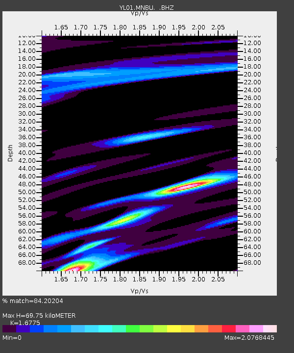
MNBU YL.MNBU - Earthquake Result Viewer
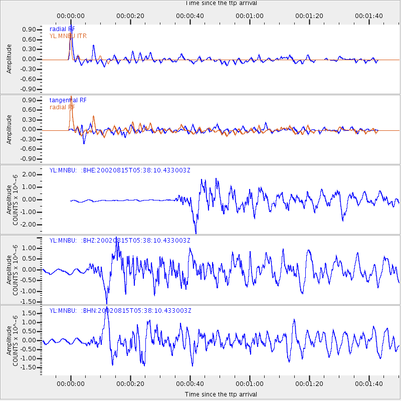
Earthquake location: Sulawesi, Indonesia
Earthquake latitude/longitude: -1.2/121.3
Earthquake time(UTC): 2002/08/15 (227) 05:30:26 GMT
Earthquake Depth: 10 km
Earthquake Magnitude: 5.7 MB, 5.8 MS, 6.2 MW, 6.1 MW
Earthquake Catalog/Contributor: WHDF/NEIC
Network: YL Himalayan Nepal Tibet Experiment
Station: MNBU YL.MNBU
Lat/Lon: 28.76 N/86.16 E
Elevation: 4500 m
Distance: 45.0 deg
Az: 314.289 deg
Baz: 125.404 deg
Ray Param: 0.07159642
Estimated Moho Depth: 69.75 km
Estimated Crust Vp/Vs: 1.68
Assumed Crust Vp: 6.514 km/s
Estimated Crust Vs: 3.883 km/s
Estimated Crust Poisson's Ratio: 0.22
Radial Match: 84.20204 %
Radial Bump: 400
Transverse Match: 80.91554 %
Transverse Bump: 400
SOD ConfigId: 16820
Insert Time: 2010-02-26 16:00:02.991 +0000
GWidth: 2.5
Max Bumps: 400
Tol: 0.001

Signal To Noise

ChannelStoNSTALTA
YL:MNBU: :BHZ:20020815T05:38:10.433003Z1.61980941.02531125E-76.3298266E-8
YL:MNBU: :BHN:20020815T05:38:10.433003Z1.10196721.1232958E-71.01935505E-7
YL:MNBU: :BHE:20020815T05:38:10.433003Z0.77141493.7039865E-84.801549E-8
Arrivals
Ps7.8 SECOND
PpPs27 SECOND
PsPs/PpSs35 SECOND