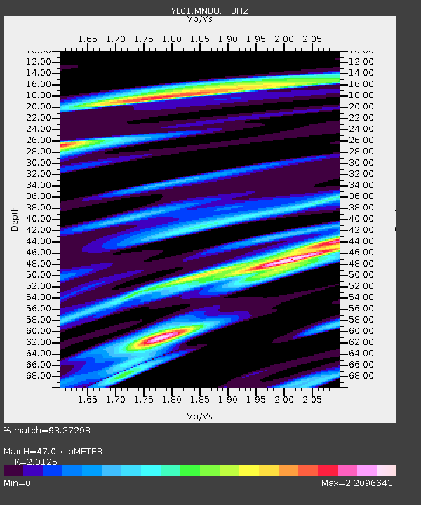
MNBU YL.MNBU - Earthquake Result Viewer
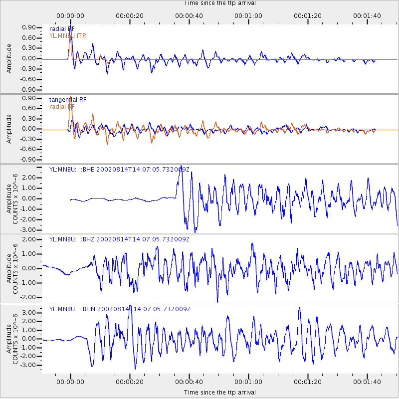
Earthquake location: Mariana Islands
Earthquake latitude/longitude: 14.1/146.2
Earthquake time(UTC): 2002/08/14 (226) 13:57:52 GMT
Earthquake Depth: 30 km
Earthquake Magnitude: 6.1 MB, 6.4 MS, 6.5 MW, 6.4 MW
Earthquake Catalog/Contributor: WHDF/NEIC
Network: YL Himalayan Nepal Tibet Experiment
Station: MNBU YL.MNBU
Lat/Lon: 28.76 N/86.16 E
Elevation: 4500 m
Distance: 57.2 deg
Az: 295.215 deg
Baz: 91.318 deg
Ray Param: 0.06357704
Estimated Moho Depth: 47.0 km
Estimated Crust Vp/Vs: 2.01
Assumed Crust Vp: 6.514 km/s
Estimated Crust Vs: 3.237 km/s
Estimated Crust Poisson's Ratio: 0.34
Radial Match: 93.37298 %
Radial Bump: 400
Transverse Match: 82.80766 %
Transverse Bump: 400
SOD ConfigId: 16820
Insert Time: 2010-02-26 16:00:05.595 +0000
GWidth: 2.5
Max Bumps: 400
Tol: 0.001

Signal To Noise

ChannelStoNSTALTA
YL:MNBU: :BHZ:20020814T14:07:05.732009Z0.661008541.7079365E-72.583834E-7
YL:MNBU: :BHN:20020814T14:07:05.732009Z1.63383852.0943301E-71.2818464E-7
YL:MNBU: :BHE:20020814T14:07:05.732009Z1.73286251.4452091E-78.340011E-8
Arrivals
Ps7.6 SECOND
PpPs21 SECOND
PsPs/PpSs28 SECOND