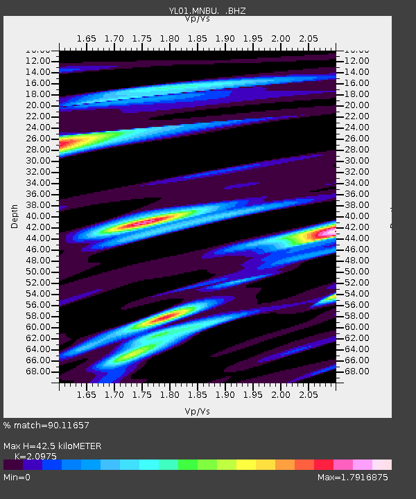
MNBU YL.MNBU - Earthquake Result Viewer
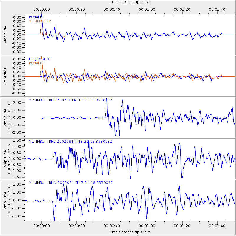
Earthquake location: W. Caroline Islands, Micronesia
Earthquake latitude/longitude: 7.8/136.9
Earthquake time(UTC): 2002/08/14 (226) 13:12:39 GMT
Earthquake Depth: 10 km
Earthquake Magnitude: 6.1 MB, 6.0 MS, 6.3 MW, 6.3 MW
Earthquake Catalog/Contributor: WHDF/NEIC
Network: YL Himalayan Nepal Tibet Experiment
Station: MNBU YL.MNBU
Lat/Lon: 28.76 N/86.16 E
Elevation: 4500 m
Distance: 52.0 deg
Az: 300.413 deg
Baz: 103.306 deg
Ray Param: 0.06703849
Estimated Moho Depth: 42.5 km
Estimated Crust Vp/Vs: 2.10
Assumed Crust Vp: 6.514 km/s
Estimated Crust Vs: 3.106 km/s
Estimated Crust Poisson's Ratio: 0.35
Radial Match: 90.11657 %
Radial Bump: 400
Transverse Match: 79.09257 %
Transverse Bump: 400
SOD ConfigId: 16820
Insert Time: 2010-02-26 16:00:06.645 +0000
GWidth: 2.5
Max Bumps: 400
Tol: 0.001

Signal To Noise

ChannelStoNSTALTA
YL:MNBU: :BHZ:20020814T13:21:18.333003Z0.607977457.7492594E-81.2745966E-7
YL:MNBU: :BHN:20020814T13:21:18.333003Z1.46831135.7669606E-83.9276145E-8
YL:MNBU: :BHE:20020814T13:21:18.333003Z0.500793.504798E-86.998538E-8
Arrivals
Ps7.5 SECOND
PpPs19 SECOND
PsPs/PpSs27 SECOND