You are here: Home > Network List > YL01 - Himalayan Nepal Tibet Experiment Stations List
> Station MNBU YL.MNBU > Earthquake Result Viewer
MNBU YL.MNBU - Earthquake Result Viewer
| Earthquake location: |
Southeast Of Honshu, Japan |
| Earthquake latitude/longitude: |
29.3/139.0 |
| Earthquake time(UTC): |
2002/08/02 (214) 23:11:39 GMT |
| Earthquake Depth: |
426 km |
| Earthquake Magnitude: |
5.5 MB, 6.3 MW, 6.3 MW |
| Earthquake Catalog/Contributor: |
WHDF/NEIC |
|
| Network: |
YL Himalayan Nepal Tibet Experiment |
| Station: |
MNBU YL.MNBU |
| Lat/Lon: |
28.76 N/86.16 E |
| Elevation: |
4500 m |
|
| Distance: |
45.8 deg |
| Az: |
282.874 deg |
| Baz: |
75.925 deg |
| Ray Param: |
0.06914456 |
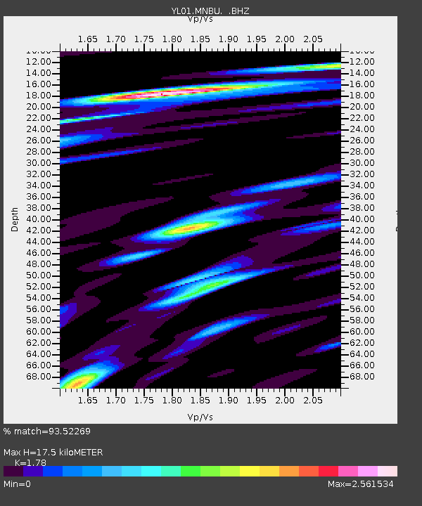
| Estimated Moho Depth: |
17.5 km |
| Estimated Crust Vp/Vs: |
1.78 |
| Assumed Crust Vp: |
6.514 km/s |
| Estimated Crust Vs: |
3.66 km/s |
| Estimated Crust Poisson's Ratio: |
0.27 |
|
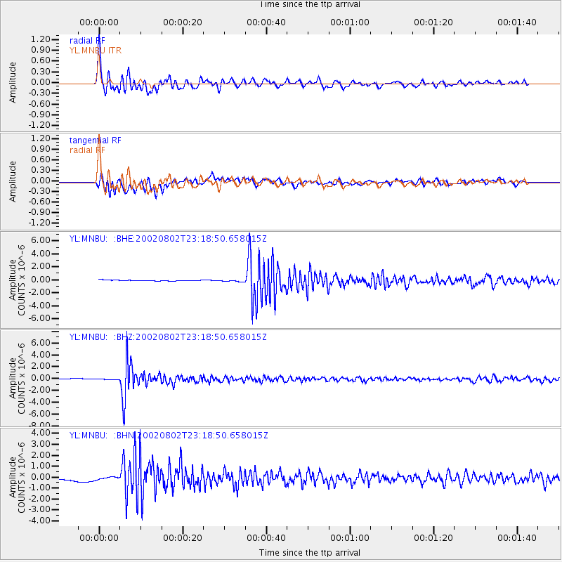
| Radial Match: |
93.52269 % |
| Radial Bump: |
400 |
| Transverse Match: |
86.50189 % |
| Transverse Bump: |
400 |
| SOD ConfigId: |
16844 |
| Insert Time: |
2010-02-26 16:00:07.770 +0000 |
| GWidth: |
2.5 |
| Max Bumps: |
400 |
| Tol: |
0.001 |
|
Signal To Noise
| Channel | StoN | STA | LTA |
| YL:MNBU: :BHZ:20020802T23:18:50.658015Z | 2.0578058 | 9.705498E-8 | 4.7164306E-8 |
| YL:MNBU: :BHN:20020802T23:18:50.658015Z | 2.384223 | 2.1789451E-7 | 9.139016E-8 |
| YL:MNBU: :BHE:20020802T23:18:50.658015Z | 1.8506953 | 1.2436314E-7 | 6.7198066E-8 |
| Arrivals |
| Ps | 2.2 SECOND |
| PpPs | 7.0 SECOND |
| PsPs/PpSs | 9.3 SECOND |


