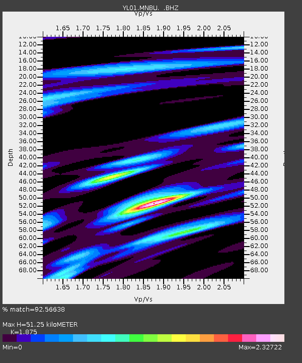
MNBU YL.MNBU - Earthquake Result Viewer
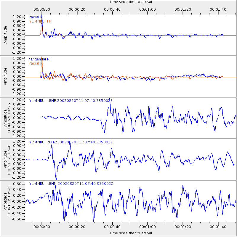
Earthquake location: Southeast Of Honshu, Japan
Earthquake latitude/longitude: 31.0/142.0
Earthquake time(UTC): 2002/08/20 (232) 10:59:32 GMT
Earthquake Depth: 9.0 km
Earthquake Magnitude: 5.4 MB, 6.2 MS, 6.3 MW, 6.1 MW
Earthquake Catalog/Contributor: WHDF/NEIC
Network: YL Himalayan Nepal Tibet Experiment
Station: MNBU YL.MNBU
Lat/Lon: 28.76 N/86.16 E
Elevation: 4500 m
Distance: 48.0 deg
Az: 282.291 deg
Baz: 72.88 deg
Ray Param: 0.06963111
Estimated Moho Depth: 51.25 km
Estimated Crust Vp/Vs: 1.88
Assumed Crust Vp: 6.514 km/s
Estimated Crust Vs: 3.474 km/s
Estimated Crust Poisson's Ratio: 0.30
Radial Match: 92.56638 %
Radial Bump: 396
Transverse Match: 76.28206 %
Transverse Bump: 400
SOD ConfigId: 16844
Insert Time: 2010-02-26 16:00:08.621 +0000
GWidth: 2.5
Max Bumps: 400
Tol: 0.001

Signal To Noise

ChannelStoNSTALTA
YL:MNBU: :BHZ:20020820T11:07:40.335002Z5.0829471.8338478E-73.607844E-8
YL:MNBU: :BHN:20020820T11:07:40.335002Z2.2352113.392142E-71.5175937E-7
YL:MNBU: :BHE:20020820T11:07:40.335002Z3.72453262.8338178E-77.608519E-8
Arrivals
Ps7.3 SECOND
PpPs21 SECOND
PsPs/PpSs29 SECOND