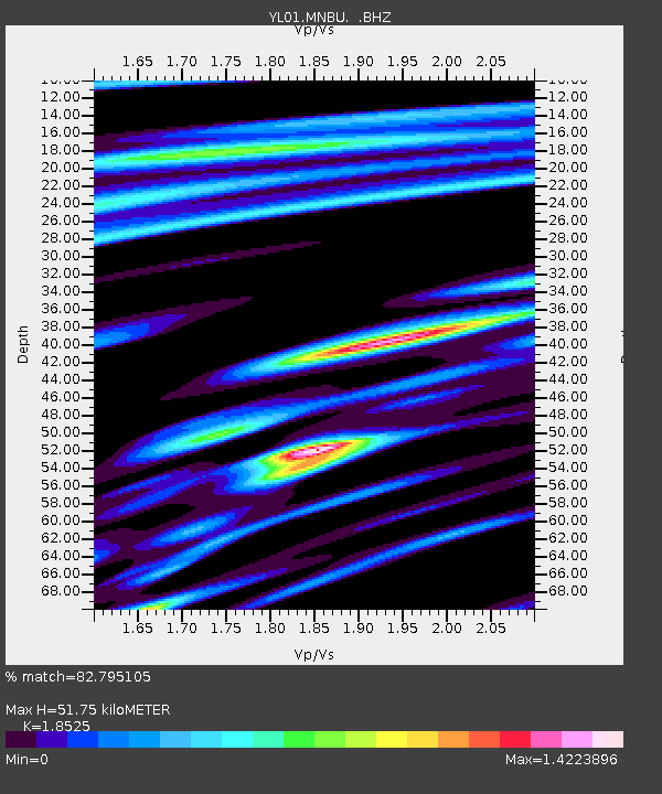
MNBU YL.MNBU - Earthquake Result Viewer
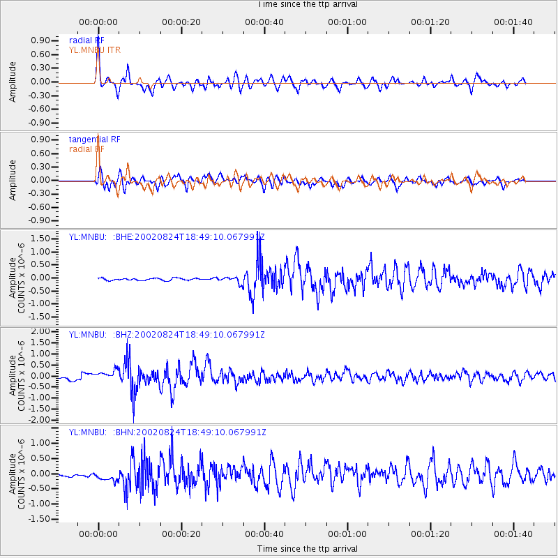
Earthquake location: Kuril Islands
Earthquake latitude/longitude: 43.1/146.1
Earthquake time(UTC): 2002/08/24 (236) 18:40:53 GMT
Earthquake Depth: 43 km
Earthquake Magnitude: 5.9 MB, 5.8 MS, 6.2 MW, 6.1 MW
Earthquake Catalog/Contributor: WHDF/NEIC
Network: YL Himalayan Nepal Tibet Experiment
Station: MNBU YL.MNBU
Lat/Lon: 28.76 N/86.16 E
Elevation: 4500 m
Distance: 49.6 deg
Az: 273.85 deg
Baz: 56.322 deg
Ray Param: 0.06848623
Estimated Moho Depth: 51.75 km
Estimated Crust Vp/Vs: 1.85
Assumed Crust Vp: 6.514 km/s
Estimated Crust Vs: 3.516 km/s
Estimated Crust Poisson's Ratio: 0.29
Radial Match: 82.795105 %
Radial Bump: 400
Transverse Match: 76.43176 %
Transverse Bump: 400
SOD ConfigId: 16844
Insert Time: 2010-02-26 16:00:09.458 +0000
GWidth: 2.5
Max Bumps: 400
Tol: 0.001

Signal To Noise

ChannelStoNSTALTA
YL:MNBU: :BHZ:20020824T18:49:10.067991Z4.6550042.6478082E-75.68809E-8
YL:MNBU: :BHN:20020824T18:49:10.067991Z2.77156542.3739153E-78.565251E-8
YL:MNBU: :BHE:20020824T18:49:10.067991Z3.07856351.2869124E-74.180237E-8
Arrivals
Ps7.2 SECOND
PpPs21 SECOND
PsPs/PpSs29 SECOND