You are here: Home > Network List > YL01 - Himalayan Nepal Tibet Experiment Stations List
> Station MNBU YL.MNBU > Earthquake Result Viewer
MNBU YL.MNBU - Earthquake Result Viewer
| Earthquake location: |
Sunda Strait, Indonesia |
| Earthquake latitude/longitude: |
-6.8/105.7 |
| Earthquake time(UTC): |
2002/08/26 (238) 14:55:13 GMT |
| Earthquake Depth: |
63 km |
| Earthquake Magnitude: |
5.6 MB, 5.8 MW, 5.7 MW |
| Earthquake Catalog/Contributor: |
WHDF/NEIC |
|
| Network: |
YL Himalayan Nepal Tibet Experiment |
| Station: |
MNBU YL.MNBU |
| Lat/Lon: |
28.76 N/86.16 E |
| Elevation: |
4500 m |
|
| Distance: |
40.0 deg |
| Az: |
332.816 deg |
| Baz: |
148.886 deg |
| Ray Param: |
0.07446468 |
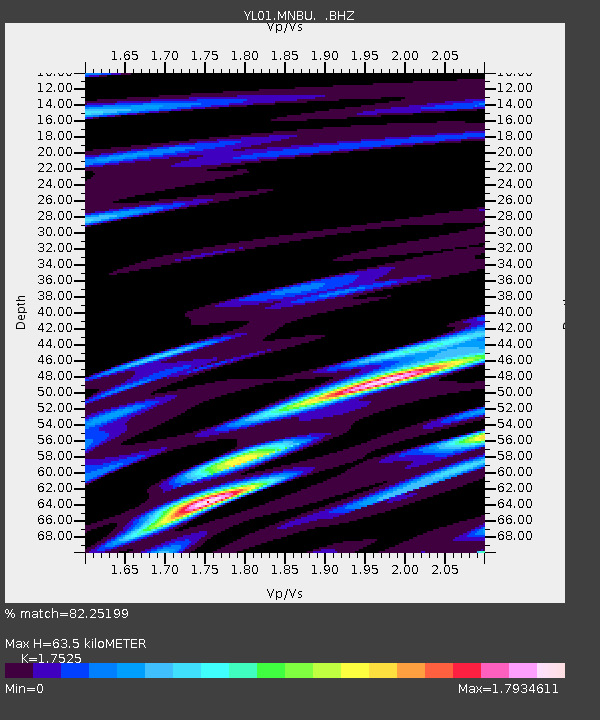
| Estimated Moho Depth: |
63.5 km |
| Estimated Crust Vp/Vs: |
1.75 |
| Assumed Crust Vp: |
6.514 km/s |
| Estimated Crust Vs: |
3.717 km/s |
| Estimated Crust Poisson's Ratio: |
0.26 |
|
| Radial Match: |
82.25199 % |
| Radial Bump: |
400 |
| Transverse Match: |
62.13296 % |
| Transverse Bump: |
400 |
| SOD ConfigId: |
16844 |
| Insert Time: |
2010-02-26 16:00:10.301 +0000 |
| GWidth: |
2.5 |
| Max Bumps: |
400 |
| Tol: |
0.001 |
|

Signal To Noise
| Channel | StoN | STA | LTA |
| YL:MNBU: :BHZ:20020826T15:02:12.268003Z | 4.9350977 | 1.1569298E-7 | 2.3442894E-8 |
| YL:MNBU: :BHN:20020826T15:02:12.268003Z | 3.0838623 | 1.0960411E-7 | 3.554118E-8 |
| YL:MNBU: :BHE:20020826T15:02:12.268003Z | 1.7894514 | 5.6502152E-8 | 3.1575127E-8 |
| Arrivals |
| Ps | 7.9 SECOND |
| PpPs | 25 SECOND |
| PsPs/PpSs | 33 SECOND |


