You are here: Home > Network List > YL01 - Himalayan Nepal Tibet Experiment Stations List
> Station MNBU YL.MNBU > Earthquake Result Viewer
MNBU YL.MNBU - Earthquake Result Viewer
| Earthquake location: |
Northeastern China |
| Earthquake latitude/longitude: |
44.8/129.9 |
| Earthquake time(UTC): |
2002/09/15 (258) 08:39:32 GMT |
| Earthquake Depth: |
586 km |
| Earthquake Magnitude: |
5.8 MB, 6.4 MW, 6.4 MW |
| Earthquake Catalog/Contributor: |
WHDF/NEIC |
|
| Network: |
YL Himalayan Nepal Tibet Experiment |
| Station: |
MNBU YL.MNBU |
| Lat/Lon: |
28.76 N/86.16 E |
| Elevation: |
4500 m |
|
| Distance: |
38.0 deg |
| Az: |
260.187 deg |
| Baz: |
52.988 deg |
| Ray Param: |
0.07277637 |
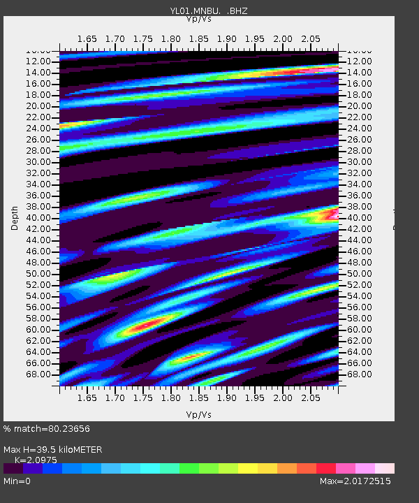
| Estimated Moho Depth: |
39.5 km |
| Estimated Crust Vp/Vs: |
2.10 |
| Assumed Crust Vp: |
6.514 km/s |
| Estimated Crust Vs: |
3.106 km/s |
| Estimated Crust Poisson's Ratio: |
0.35 |
|
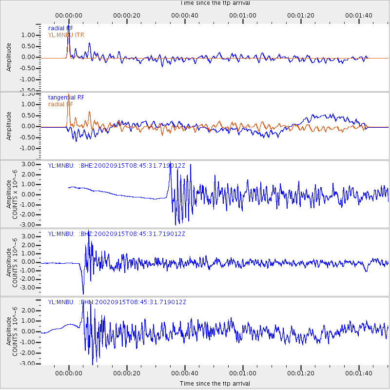
| Radial Match: |
80.23656 % |
| Radial Bump: |
400 |
| Transverse Match: |
61.893803 % |
| Transverse Bump: |
400 |
| SOD ConfigId: |
16844 |
| Insert Time: |
2010-02-26 16:00:16.300 +0000 |
| GWidth: |
2.5 |
| Max Bumps: |
400 |
| Tol: |
0.001 |
|
Signal To Noise
| Channel | StoN | STA | LTA |
| YL:MNBU: :BHZ:20020915T08:45:31.719012Z | 23.039658 | 6.813413E-7 | 2.9572544E-8 |
| YL:MNBU: :BHN:20020915T08:45:31.719012Z | 3.4832852 | 1.2866632E-6 | 3.693821E-7 |
| YL:MNBU: :BHE:20020915T08:45:31.719012Z | 2.0044672 | 6.897541E-7 | 3.4410846E-7 |
| Arrivals |
| Ps | 7.1 SECOND |
| PpPs | 18 SECOND |
| PsPs/PpSs | 25 SECOND |


