You are here: Home > Network List > YL01 - Himalayan Nepal Tibet Experiment Stations List
> Station MNBU YL.MNBU > Earthquake Result Viewer
MNBU YL.MNBU - Earthquake Result Viewer
| Earthquake location: |
Bali Sea |
| Earthquake latitude/longitude: |
-7.5/115.7 |
| Earthquake time(UTC): |
2002/10/03 (276) 19:05:10 GMT |
| Earthquake Depth: |
316 km |
| Earthquake Magnitude: |
6.0 MB, 6.0 MW, 6.0 MW |
| Earthquake Catalog/Contributor: |
WHDF/NEIC |
|
| Network: |
YL Himalayan Nepal Tibet Experiment |
| Station: |
MNBU YL.MNBU |
| Lat/Lon: |
28.76 N/86.16 E |
| Elevation: |
4500 m |
|
| Distance: |
45.9 deg |
| Az: |
323.008 deg |
| Baz: |
137.198 deg |
| Ray Param: |
0.06966126 |
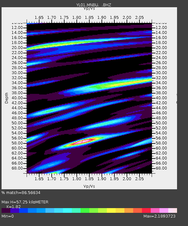
| Estimated Moho Depth: |
57.25 km |
| Estimated Crust Vp/Vs: |
1.82 |
| Assumed Crust Vp: |
6.514 km/s |
| Estimated Crust Vs: |
3.579 km/s |
| Estimated Crust Poisson's Ratio: |
0.28 |
|
| Radial Match: |
86.56634 % |
| Radial Bump: |
400 |
| Transverse Match: |
79.39387 % |
| Transverse Bump: |
400 |
| SOD ConfigId: |
16844 |
| Insert Time: |
2010-02-26 16:00:18.051 +0000 |
| GWidth: |
2.5 |
| Max Bumps: |
400 |
| Tol: |
0.001 |
|
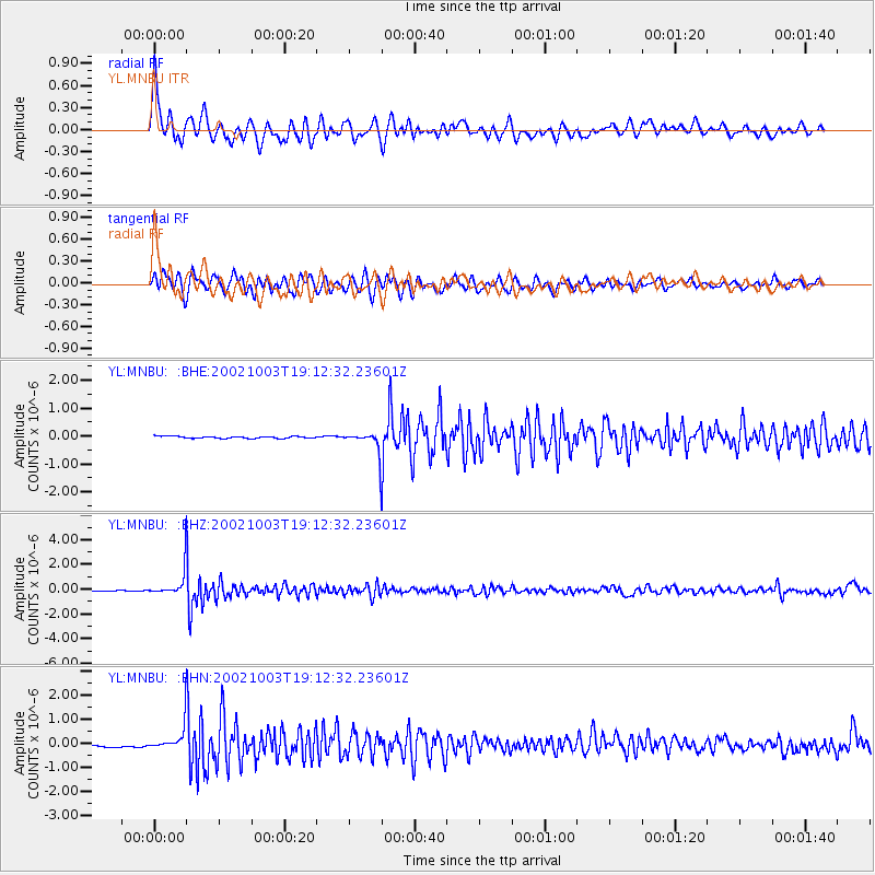
Signal To Noise
| Channel | StoN | STA | LTA |
| YL:MNBU: :BHZ:20021003T19:12:32.23601Z | 32.387856 | 1.0007661E-6 | 3.0899425E-8 |
| YL:MNBU: :BHN:20021003T19:12:32.23601Z | 8.3415165 | 4.7285238E-7 | 5.668662E-8 |
| YL:MNBU: :BHE:20021003T19:12:32.23601Z | 10.990147 | 4.0791696E-7 | 3.711661E-8 |
| Arrivals |
| Ps | 7.7 SECOND |
| PpPs | 23 SECOND |
| PsPs/PpSs | 31 SECOND |


