You are here: Home > Network List > YL01 - Himalayan Nepal Tibet Experiment Stations List
> Station MNBU YL.MNBU > Earthquake Result Viewer
MNBU YL.MNBU - Earthquake Result Viewer
| Earthquake location: |
Philippine Islands Region |
| Earthquake latitude/longitude: |
15.1/118.5 |
| Earthquake time(UTC): |
2002/10/12 (285) 23:43:12 GMT |
| Earthquake Depth: |
33 km |
| Earthquake Magnitude: |
5.6 MB, 5.6 MS, 6.1 MW |
| Earthquake Catalog/Contributor: |
WHDF/NEIC |
|
| Network: |
YL Himalayan Nepal Tibet Experiment |
| Station: |
MNBU YL.MNBU |
| Lat/Lon: |
28.76 N/86.16 E |
| Elevation: |
4500 m |
|
| Distance: |
32.8 deg |
| Az: |
299.917 deg |
| Baz: |
107.54 deg |
| Ray Param: |
0.078440405 |
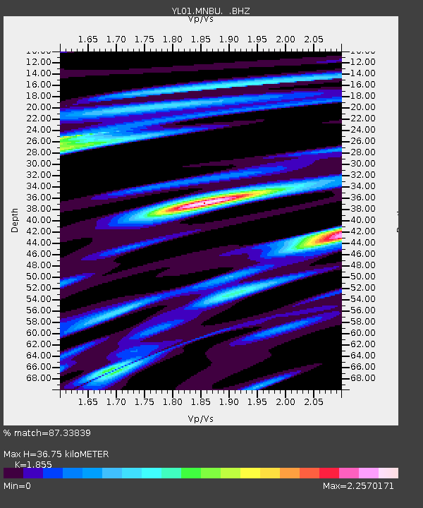
| Estimated Moho Depth: |
36.75 km |
| Estimated Crust Vp/Vs: |
1.86 |
| Assumed Crust Vp: |
6.514 km/s |
| Estimated Crust Vs: |
3.512 km/s |
| Estimated Crust Poisson's Ratio: |
0.30 |
|
| Radial Match: |
87.33839 % |
| Radial Bump: |
375 |
| Transverse Match: |
70.28292 % |
| Transverse Bump: |
400 |
| SOD ConfigId: |
16844 |
| Insert Time: |
2010-02-26 16:00:20.299 +0000 |
| GWidth: |
2.5 |
| Max Bumps: |
400 |
| Tol: |
0.001 |
|
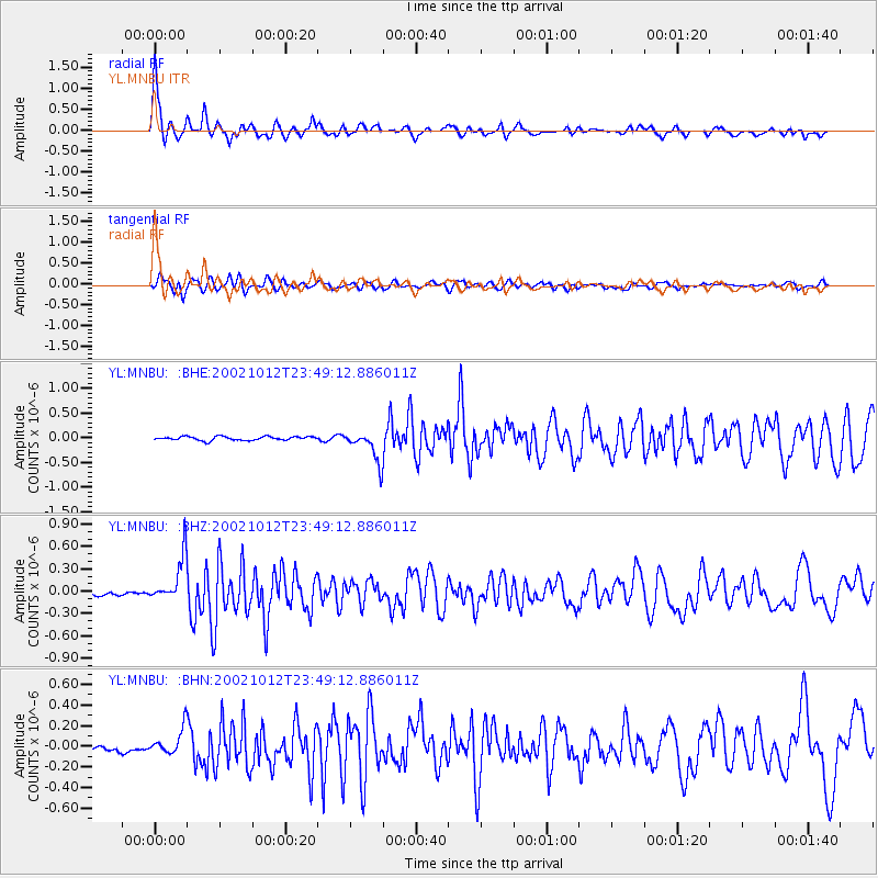
Signal To Noise
| Channel | StoN | STA | LTA |
| YL:MNBU: :BHZ:20021012T23:49:12.886011Z | 12.296585 | 3.048929E-7 | 2.4794923E-8 |
| YL:MNBU: :BHN:20021012T23:49:12.886011Z | 3.23295 | 1.2225587E-7 | 3.781558E-8 |
| YL:MNBU: :BHE:20021012T23:49:12.886011Z | 8.132429 | 3.1315915E-7 | 3.8507455E-8 |
| Arrivals |
| Ps | 5.2 SECOND |
| PpPs | 15 SECOND |
| PsPs/PpSs | 20 SECOND |


