You are here: Home > Network List > YL01 - Himalayan Nepal Tibet Experiment Stations List
> Station MNBU YL.MNBU > Earthquake Result Viewer
MNBU YL.MNBU - Earthquake Result Viewer
| Earthquake location: |
Near East Coast Of Kamchatka |
| Earthquake latitude/longitude: |
52.0/157.3 |
| Earthquake time(UTC): |
2002/10/16 (289) 10:12:21 GMT |
| Earthquake Depth: |
102 km |
| Earthquake Magnitude: |
6.1 MB, 6.2 MW, 6.2 MW |
| Earthquake Catalog/Contributor: |
WHDF/NEIC |
|
| Network: |
YL Himalayan Nepal Tibet Experiment |
| Station: |
MNBU YL.MNBU |
| Lat/Lon: |
28.76 N/86.16 E |
| Elevation: |
4500 m |
|
| Distance: |
56.5 deg |
| Az: |
275.055 deg |
| Baz: |
44.597 deg |
| Ray Param: |
0.06376864 |
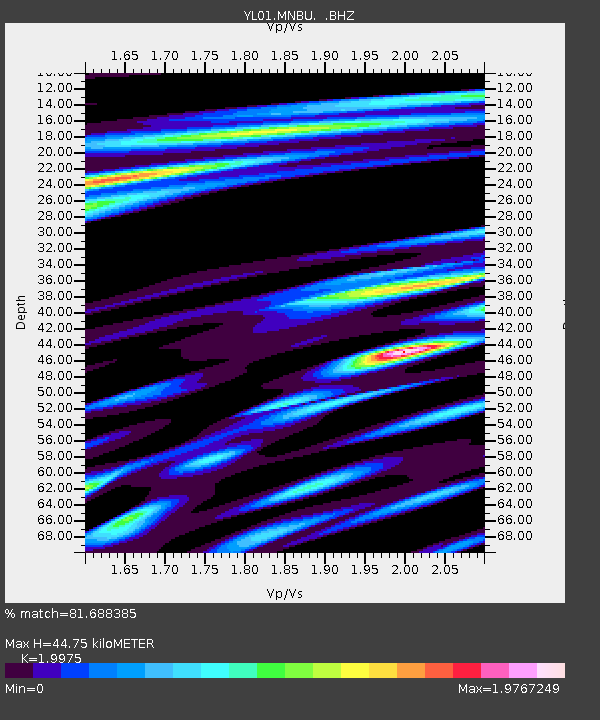
| Estimated Moho Depth: |
44.75 km |
| Estimated Crust Vp/Vs: |
2.00 |
| Assumed Crust Vp: |
6.514 km/s |
| Estimated Crust Vs: |
3.261 km/s |
| Estimated Crust Poisson's Ratio: |
0.33 |
|
| Radial Match: |
81.688385 % |
| Radial Bump: |
400 |
| Transverse Match: |
86.186584 % |
| Transverse Bump: |
400 |
| SOD ConfigId: |
16844 |
| Insert Time: |
2010-02-26 16:00:22.077 +0000 |
| GWidth: |
2.5 |
| Max Bumps: |
400 |
| Tol: |
0.001 |
|
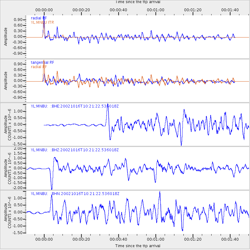
Signal To Noise
| Channel | StoN | STA | LTA |
| YL:MNBU: :BHZ:20021016T10:21:22.536018Z | 25.189201 | 7.920362E-7 | 3.144348E-8 |
| YL:MNBU: :BHN:20021016T10:21:22.536018Z | 7.5019293 | 4.5902945E-7 | 6.118819E-8 |
| YL:MNBU: :BHE:20021016T10:21:22.536018Z | 13.809635 | 5.819259E-7 | 4.213912E-8 |
| Arrivals |
| Ps | 7.2 SECOND |
| PpPs | 20 SECOND |
| PsPs/PpSs | 27 SECOND |


