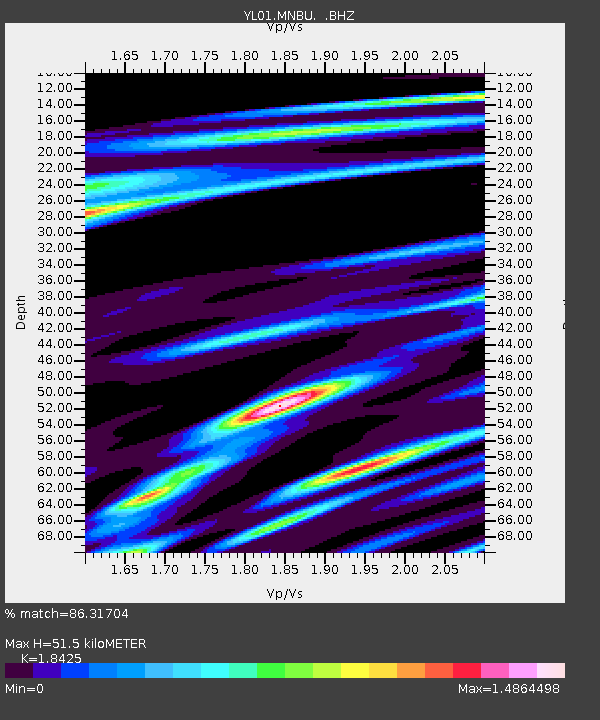
MNBU YL.MNBU - Earthquake Result Viewer
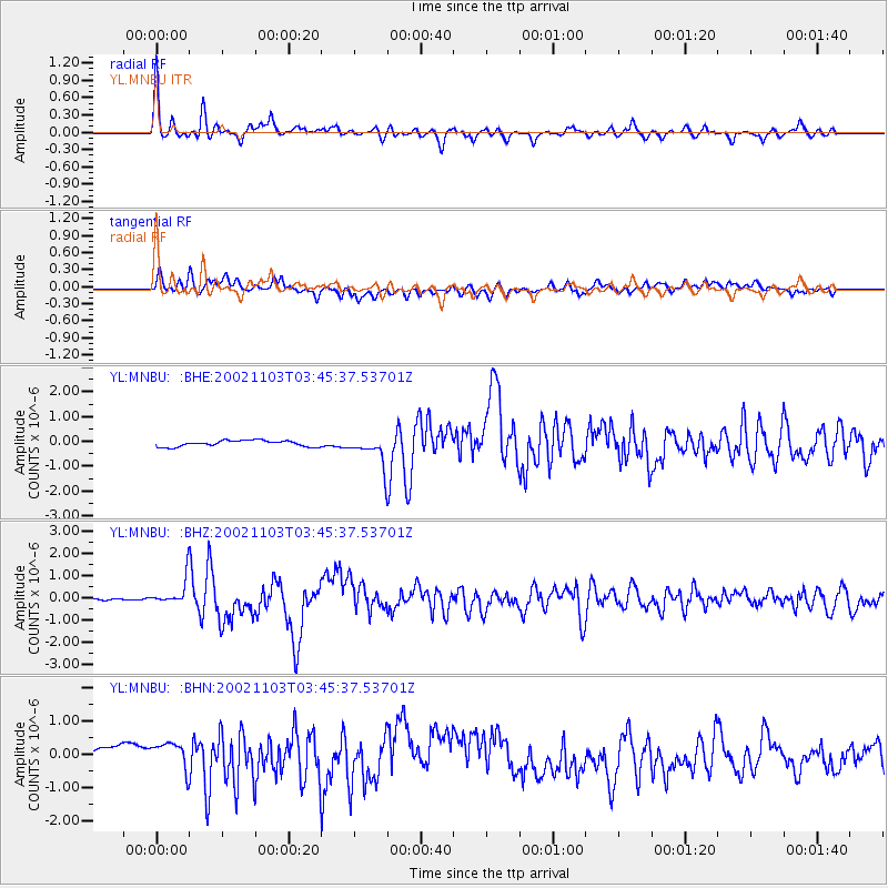
Earthquake location: Near East Coast Of Honshu, Japan
Earthquake latitude/longitude: 38.9/142.0
Earthquake time(UTC): 2002/11/03 (307) 03:37:42 GMT
Earthquake Depth: 39 km
Earthquake Magnitude: 5.7 MB, 6.1 MS, 6.4 MW, 6.4 MW
Earthquake Catalog/Contributor: WHDF/NEIC
Network: YL Himalayan Nepal Tibet Experiment
Station: MNBU YL.MNBU
Lat/Lon: 28.76 N/86.16 E
Elevation: 4500 m
Distance: 46.8 deg
Az: 275.12 deg
Baz: 62.29 deg
Ray Param: 0.07030875
Estimated Moho Depth: 51.5 km
Estimated Crust Vp/Vs: 1.84
Assumed Crust Vp: 6.514 km/s
Estimated Crust Vs: 3.536 km/s
Estimated Crust Poisson's Ratio: 0.29
Radial Match: 86.31704 %
Radial Bump: 400
Transverse Match: 74.06065 %
Transverse Bump: 400
SOD ConfigId: 16844
Insert Time: 2010-02-26 16:00:26.503 +0000
GWidth: 2.5
Max Bumps: 400
Tol: 0.001

Signal To Noise

ChannelStoNSTALTA
YL:MNBU: :BHZ:20021103T03:45:37.53701Z13.6440025.723313E-74.194747E-8
YL:MNBU: :BHN:20021103T03:45:37.53701Z2.18592265.062825E-72.3161044E-7
YL:MNBU: :BHE:20021103T03:45:37.53701Z4.8798465.942582E-71.2177807E-7
Arrivals
Ps7.1 SECOND
PpPs21 SECOND
PsPs/PpSs28 SECOND