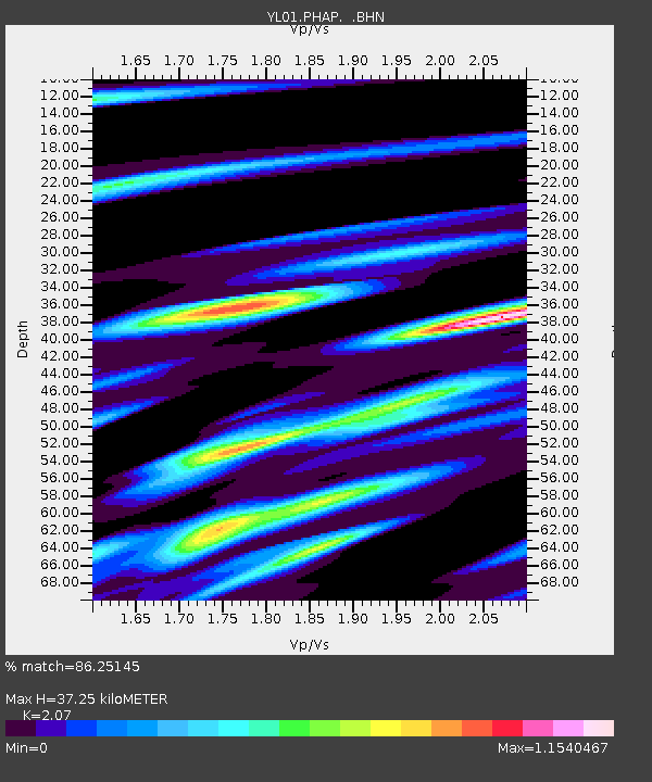
PHAP YL.PHAP - Earthquake Result Viewer
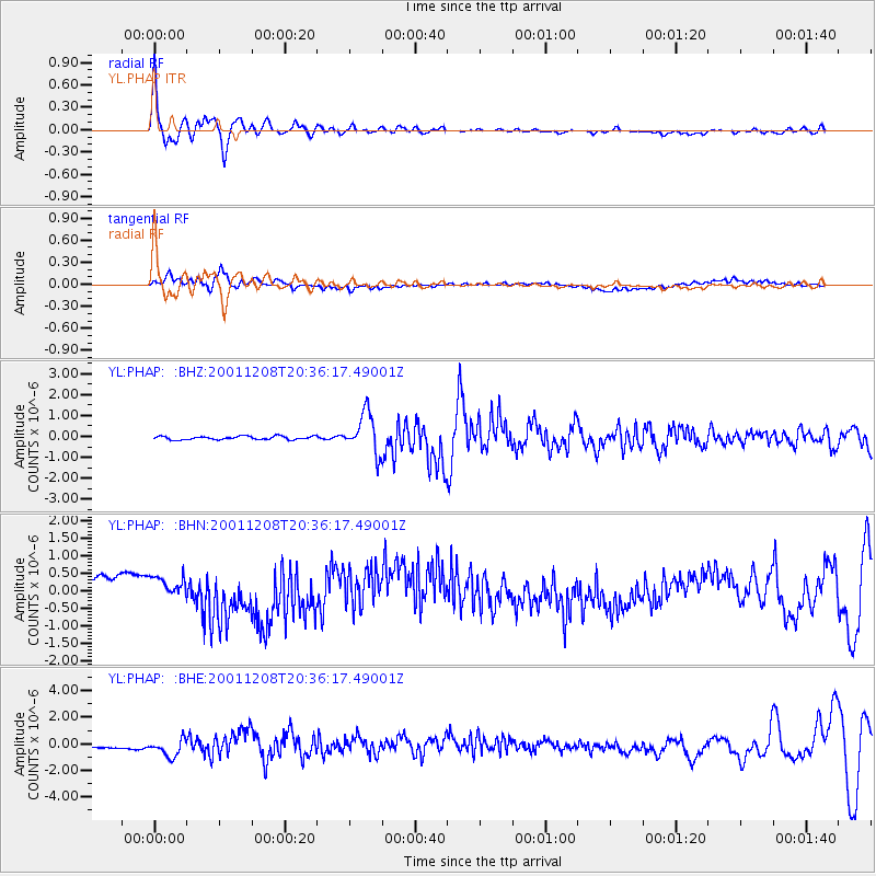
Earthquake location: Ryukyu Islands, Japan
Earthquake latitude/longitude: 28.3/129.6
Earthquake time(UTC): 2001/12/08 (342) 20:29:34 GMT
Earthquake Depth: 33 km
Earthquake Magnitude: 5.7 MB, 5.7 MS, 6.2 MW, 6.1 MW
Earthquake Catalog/Contributor: WHDF/NEIC
Network: YL Himalayan Nepal Tibet Experiment
Station: PHAP YL.PHAP
Lat/Lon: 27.51 N/86.58 E
Elevation: 2488 m
Distance: 37.9 deg
Az: 279.33 deg
Baz: 78.566 deg
Ray Param: 0.075832225
Estimated Moho Depth: 37.25 km
Estimated Crust Vp/Vs: 2.07
Assumed Crust Vp: 6.236 km/s
Estimated Crust Vs: 3.012 km/s
Estimated Crust Poisson's Ratio: 0.35
Radial Match: 86.25145 %
Radial Bump: 360
Transverse Match: 62.84471 %
Transverse Bump: 400
SOD ConfigId: 16820
Insert Time: 2010-02-26 16:01:28.542 +0000
GWidth: 2.5
Max Bumps: 400
Tol: 0.001

Signal To Noise

ChannelStoNSTALTA
YL:PHAP: :BHN:20011208T20:36:17.49001Z1.06531373.2564964E-73.0568424E-7
YL:PHAP: :BHE:20011208T20:36:17.49001Z4.8434196.818421E-71.4077702E-7
YL:PHAP: :BHZ:20011208T20:36:17.49001Z11.6906789.574037E-78.1894626E-8
Arrivals
Ps6.8 SECOND
PpPs17 SECOND
PsPs/PpSs24 SECOND