You are here: Home > Network List > YL01 - Himalayan Nepal Tibet Experiment Stations List
> Station PHAP YL.PHAP > Earthquake Result Viewer
PHAP YL.PHAP - Earthquake Result Viewer
| Earthquake location: |
Eastern Honshu, Japan |
| Earthquake latitude/longitude: |
39.4/141.1 |
| Earthquake time(UTC): |
2001/12/02 (336) 13:01:53 GMT |
| Earthquake Depth: |
124 km |
| Earthquake Magnitude: |
6.1 MB, 6.5 MW, 6.5 MW |
| Earthquake Catalog/Contributor: |
WHDF/NEIC |
|
| Network: |
YL Himalayan Nepal Tibet Experiment |
| Station: |
PHAP YL.PHAP |
| Lat/Lon: |
27.51 N/86.58 E |
| Elevation: |
2488 m |
|
| Distance: |
46.4 deg |
| Az: |
272.378 deg |
| Baz: |
60.647 deg |
| Ray Param: |
0.070256345 |
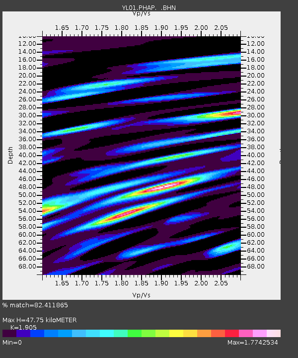
| Estimated Moho Depth: |
47.75 km |
| Estimated Crust Vp/Vs: |
1.90 |
| Assumed Crust Vp: |
6.236 km/s |
| Estimated Crust Vs: |
3.273 km/s |
| Estimated Crust Poisson's Ratio: |
0.31 |
|
| Radial Match: |
82.411865 % |
| Radial Bump: |
400 |
| Transverse Match: |
82.90244 % |
| Transverse Bump: |
400 |
| SOD ConfigId: |
16820 |
| Insert Time: |
2010-02-26 16:01:30.074 +0000 |
| GWidth: |
2.5 |
| Max Bumps: |
400 |
| Tol: |
0.001 |
|

Signal To Noise
| Channel | StoN | STA | LTA |
| YL:PHAP: :BHN:20011202T13:09:36.939012Z | 23.363575 | 1.7979139E-6 | 7.695372E-8 |
| YL:PHAP: :BHE:20011202T13:09:36.939012Z | 23.994225 | 2.4658661E-6 | 1.0276916E-7 |
| YL:PHAP: :BHZ:20011202T13:09:36.939012Z | 151.99516 | 7.0931583E-6 | 4.6667E-8 |
| Arrivals |
| Ps | 7.3 SECOND |
| PpPs | 21 SECOND |
| PsPs/PpSs | 28 SECOND |


