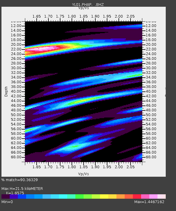
PHAP YL.PHAP - Earthquake Result Viewer
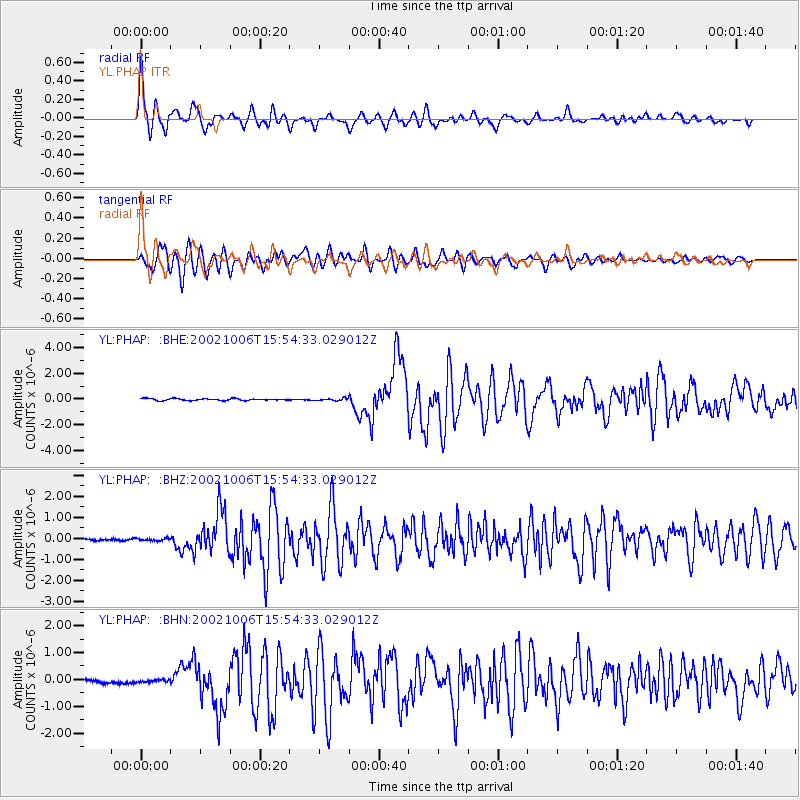
Earthquake location: Sumbawa Region, Indonesia
Earthquake latitude/longitude: -8.2/118.3
Earthquake time(UTC): 2002/10/06 (279) 15:46:33 GMT
Earthquake Depth: 10 km
Earthquake Magnitude: 5.8 MB, 6.0 MS, 6.2 MW, 6.2 MW
Earthquake Catalog/Contributor: WHDF/NEIC
Network: YL Himalayan Nepal Tibet Experiment
Station: PHAP YL.PHAP
Lat/Lon: 27.51 N/86.58 E
Elevation: 2488 m
Distance: 47.0 deg
Az: 320.241 deg
Baz: 134.534 deg
Ray Param: 0.07030702
Estimated Moho Depth: 21.5 km
Estimated Crust Vp/Vs: 1.66
Assumed Crust Vp: 6.236 km/s
Estimated Crust Vs: 3.762 km/s
Estimated Crust Poisson's Ratio: 0.21
Radial Match: 90.36329 %
Radial Bump: 400
Transverse Match: 84.90529 %
Transverse Bump: 400
SOD ConfigId: 16820
Insert Time: 2010-02-26 16:01:37.652 +0000
GWidth: 2.5
Max Bumps: 400
Tol: 0.001

Signal To Noise

ChannelStoNSTALTA
YL:PHAP: :BHZ:20021006T15:54:33.029012Z1.18673225.7995578E-84.886998E-8
YL:PHAP: :BHN:20021006T15:54:33.029012Z0.96488084.572757E-84.7391936E-8
YL:PHAP: :BHE:20021006T15:54:33.029012Z1.23692949.110062E-87.365062E-8
Arrivals
Ps2.4 SECOND
PpPs8.6 SECOND
PsPs/PpSs11 SECOND