You are here: Home > Network List > IC - New China Digital Seismograph Network Stations List
> Station HIA Hailar, Neimenggu Autonomous Region, China > Earthquake Result Viewer
HIA Hailar, Neimenggu Autonomous Region, China - Earthquake Result Viewer
| Earthquake location: |
New Britain Region, P.N.G. |
| Earthquake latitude/longitude: |
-5.5/151.4 |
| Earthquake time(UTC): |
2018/03/26 (085) 09:51:00 GMT |
| Earthquake Depth: |
40 km |
| Earthquake Magnitude: |
6.6 mww |
| Earthquake Catalog/Contributor: |
NEIC PDE/us |
|
| Network: |
IC New China Digital Seismograph Network |
| Station: |
HIA Hailar, Neimenggu Autonomous Region, China |
| Lat/Lon: |
49.27 N/119.74 E |
| Elevation: |
620 m |
|
| Distance: |
61.1 deg |
| Az: |
336.876 deg |
| Baz: |
143.352 deg |
| Ray Param: |
0.061030768 |
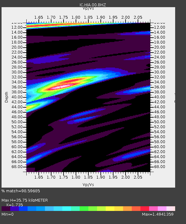
| Estimated Moho Depth: |
35.75 km |
| Estimated Crust Vp/Vs: |
1.74 |
| Assumed Crust Vp: |
6.577 km/s |
| Estimated Crust Vs: |
3.791 km/s |
| Estimated Crust Poisson's Ratio: |
0.25 |
|
| Radial Match: |
98.59685 % |
| Radial Bump: |
367 |
| Transverse Match: |
84.77776 % |
| Transverse Bump: |
400 |
| SOD ConfigId: |
2615551 |
| Insert Time: |
2018-04-09 09:52:55.013 +0000 |
| GWidth: |
2.5 |
| Max Bumps: |
400 |
| Tol: |
0.001 |
|
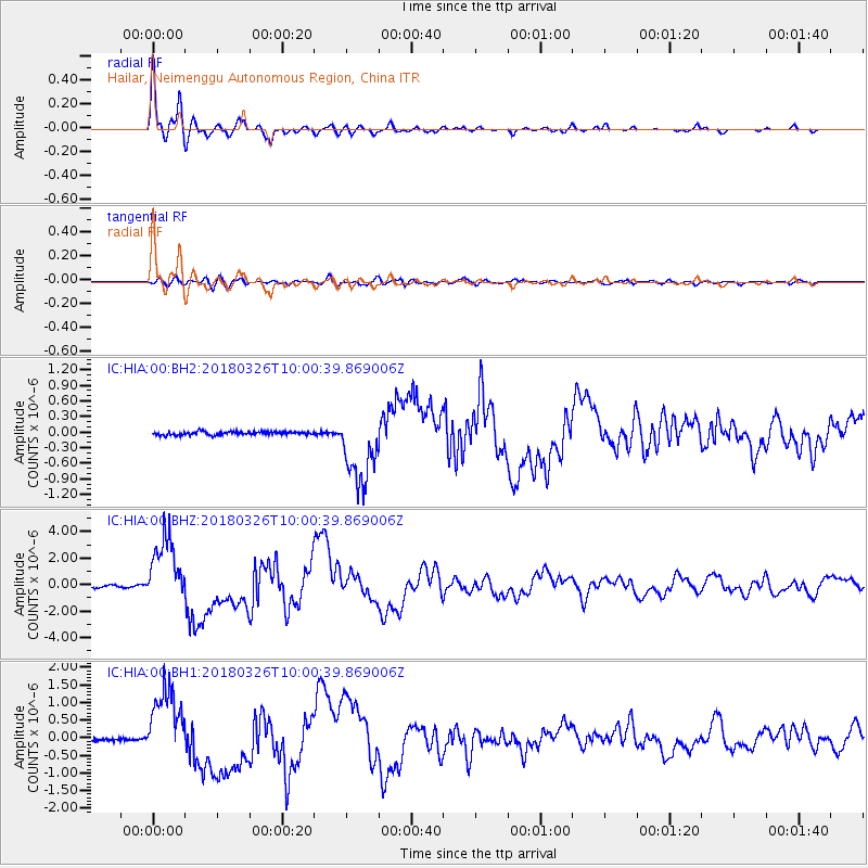
Signal To Noise
| Channel | StoN | STA | LTA |
| IC:HIA:00:BHZ:20180326T10:00:39.869006Z | 38.337814 | 2.5635652E-6 | 6.68678E-8 |
| IC:HIA:00:BH1:20180326T10:00:39.869006Z | 24.91105 | 1.0343065E-6 | 4.1519986E-8 |
| IC:HIA:00:BH2:20180326T10:00:39.869006Z | 21.771896 | 7.043985E-7 | 3.2353565E-8 |
| Arrivals |
| Ps | 4.2 SECOND |
| PpPs | 14 SECOND |
| PsPs/PpSs | 18 SECOND |


