You are here: Home > Network List > YL01 - Himalayan Nepal Tibet Experiment Stations List
> Station PHAP YL.PHAP > Earthquake Result Viewer
PHAP YL.PHAP - Earthquake Result Viewer

| Earthquake location: |
Philippine Islands Region |
| Earthquake latitude/longitude: |
19.1/121.2 |
| Earthquake time(UTC): |
2002/05/13 (133) 19:57:22 GMT |
| Earthquake Depth: |
33 km |
| Earthquake Magnitude: |
5.6 MB, 5.3 MS, 5.8 MW |
| Earthquake Catalog/Contributor: |
WHDF/NEIC |
|
| Network: |
YL Himalayan Nepal Tibet Experiment |
| Station: |
PHAP YL.PHAP |
| Lat/Lon: |
27.51 N/86.58 E |
| Elevation: |
2488 m |
|
| Distance: |
32.8 deg |
| Az: |
291.256 deg |
| Baz: |
97.214 deg |
| Ray Param: |
0.07844256 |
| Estimated Moho Depth: |
31.5 km |
| Estimated Crust Vp/Vs: |
1.89 |
| Assumed Crust Vp: |
6.236 km/s |
| Estimated Crust Vs: |
3.295 km/s |
| Estimated Crust Poisson's Ratio: |
0.31 |
|
| Radial Match: |
89.48222 % |
| Radial Bump: |
400 |
| Transverse Match: |
85.433525 % |
| Transverse Bump: |
400 |
| SOD ConfigId: |
16844 |
| Insert Time: |
2010-02-26 16:01:52.859 +0000 |
| GWidth: |
2.5 |
| Max Bumps: |
400 |
| Tol: |
0.001 |
|
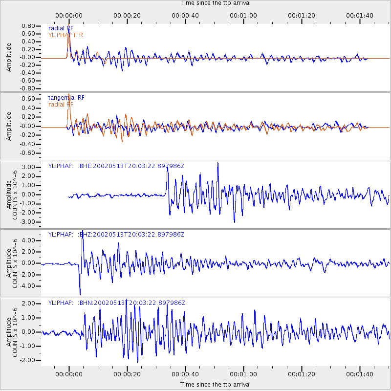
Signal To Noise
| Channel | StoN | STA | LTA |
| YL:PHAP: :BHZ:20020513T20:03:22.897986Z | 22.757015 | 2.017701E-6 | 8.8662816E-8 |
| YL:PHAP: :BHN:20020513T20:03:22.897986Z | 1.5161641 | 1.6553429E-7 | 1.09179666E-7 |
| YL:PHAP: :BHE:20020513T20:03:22.897986Z | 9.710158 | 1.0211029E-6 | 1.0515822E-7 |
| Arrivals |
| Ps | 4.8 SECOND |
| PpPs | 14 SECOND |
| PsPs/PpSs | 18 SECOND |


