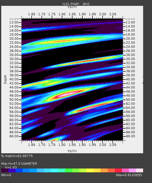
PHAP YL.PHAP - Earthquake Result Viewer

Earthquake location: W. Caroline Islands, Micronesia
Earthquake latitude/longitude: 11.0/140.7
Earthquake time(UTC): 2002/06/10 (161) 22:48:36 GMT
Earthquake Depth: 33 km
Earthquake Magnitude: 5.9 MB, 5.9 MS, 6.1 MW, 6.0 MW
Earthquake Catalog/Contributor: WHDF/NEIC
Network: YL Himalayan Nepal Tibet Experiment
Station: PHAP YL.PHAP
Lat/Lon: 27.51 N/86.58 E
Elevation: 2488 m
Distance: 53.3 deg
Az: 296.111 deg
Baz: 96.91 deg
Ray Param: 0.06616209
Estimated Moho Depth: 47.0 km
Estimated Crust Vp/Vs: 1.83
Assumed Crust Vp: 6.236 km/s
Estimated Crust Vs: 3.408 km/s
Estimated Crust Poisson's Ratio: 0.29
Radial Match: 82.89775 %
Radial Bump: 400
Transverse Match: 79.35546 %
Transverse Bump: 400
SOD ConfigId: 16844
Insert Time: 2010-02-26 16:02:02.031 +0000
GWidth: 2.5
Max Bumps: 400
Tol: 0.001

Signal To Noise

ChannelStoNSTALTA
YL:PHAP: :BHZ:20020610T22:57:20.931008Z5.06601862.5280252E-74.990162E-8
YL:PHAP: :BHN:20020610T22:57:20.931008Z0.913393265.710558E-86.252026E-8
YL:PHAP: :BHE:20020610T22:57:20.931008Z1.9477851.1406763E-75.856274E-8
Arrivals
Ps6.6 SECOND
PpPs20 SECOND
PsPs/PpSs27 SECOND