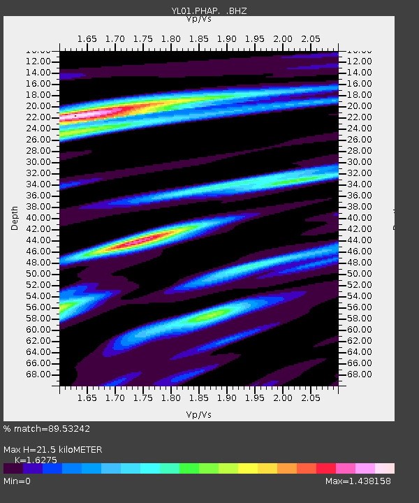
PHAP YL.PHAP - Earthquake Result Viewer

Earthquake location: Sunda Strait, Indonesia
Earthquake latitude/longitude: -7.0/104.2
Earthquake time(UTC): 2002/06/27 (178) 05:50:35 GMT
Earthquake Depth: 11 km
Earthquake Magnitude: 6.0 MB, 6.9 MS, 6.6 MW, 6.5 MW
Earthquake Catalog/Contributor: WHDF/NEIC
Network: YL Himalayan Nepal Tibet Experiment
Station: PHAP YL.PHAP
Lat/Lon: 27.51 N/86.58 E
Elevation: 2488 m
Distance: 38.3 deg
Az: 334.31 deg
Baz: 151.017 deg
Ray Param: 0.075655945
Estimated Moho Depth: 21.5 km
Estimated Crust Vp/Vs: 1.63
Assumed Crust Vp: 6.236 km/s
Estimated Crust Vs: 3.832 km/s
Estimated Crust Poisson's Ratio: 0.20
Radial Match: 89.53242 %
Radial Bump: 400
Transverse Match: 71.02088 %
Transverse Bump: 400
SOD ConfigId: 16844
Insert Time: 2010-02-26 16:02:06.224 +0000
GWidth: 2.5
Max Bumps: 400
Tol: 0.001

Signal To Noise

ChannelStoNSTALTA
YL:PHAP: :BHZ:20020627T05:57:24.481002Z3.34819672.33886E-66.9854315E-7
YL:PHAP: :BHN:20020627T05:57:24.481002Z2.33546661.9907748E-68.524098E-7
YL:PHAP: :BHE:20020627T05:57:24.481002Z1.5065521.022652E-66.7880296E-7
Arrivals
Ps2.3 SECOND
PpPs8.4 SECOND
PsPs/PpSs11 SECOND