You are here: Home > Network List > YL01 - Himalayan Nepal Tibet Experiment Stations List
> Station PHAP YL.PHAP > Earthquake Result Viewer
PHAP YL.PHAP - Earthquake Result Viewer
| Earthquake location: |
Southeast Of Honshu, Japan |
| Earthquake latitude/longitude: |
29.3/139.0 |
| Earthquake time(UTC): |
2002/08/02 (214) 23:11:39 GMT |
| Earthquake Depth: |
426 km |
| Earthquake Magnitude: |
5.5 MB, 6.3 MW, 6.3 MW |
| Earthquake Catalog/Contributor: |
WHDF/NEIC |
|
| Network: |
YL Himalayan Nepal Tibet Experiment |
| Station: |
PHAP YL.PHAP |
| Lat/Lon: |
27.51 N/86.58 E |
| Elevation: |
2488 m |
|
| Distance: |
45.8 deg |
| Az: |
281.075 deg |
| Baz: |
74.869 deg |
| Ray Param: |
0.069176584 |
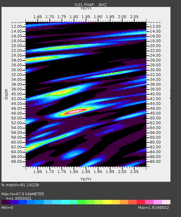
| Estimated Moho Depth: |
47.0 km |
| Estimated Crust Vp/Vs: |
1.81 |
| Assumed Crust Vp: |
6.236 km/s |
| Estimated Crust Vs: |
3.455 km/s |
| Estimated Crust Poisson's Ratio: |
0.28 |
|
| Radial Match: |
91.18229 % |
| Radial Bump: |
400 |
| Transverse Match: |
86.054306 % |
| Transverse Bump: |
400 |
| SOD ConfigId: |
16844 |
| Insert Time: |
2010-02-26 16:02:10.274 +0000 |
| GWidth: |
2.5 |
| Max Bumps: |
400 |
| Tol: |
0.001 |
|

Signal To Noise
| Channel | StoN | STA | LTA |
| YL:PHAP: :BHZ:20020802T23:18:50.256007Z | 29.48118 | 3.1267903E-6 | 1.06060554E-7 |
| YL:PHAP: :BHN:20020802T23:18:50.256007Z | 5.384744 | 5.3708646E-7 | 9.974224E-8 |
| YL:PHAP: :BHE:20020802T23:18:50.256007Z | 11.769681 | 1.2630132E-6 | 1.07310754E-7 |
| Arrivals |
| Ps | 6.4 SECOND |
| PpPs | 20 SECOND |
| PsPs/PpSs | 26 SECOND |


