PHAP YL.PHAP - Earthquake Result Viewer
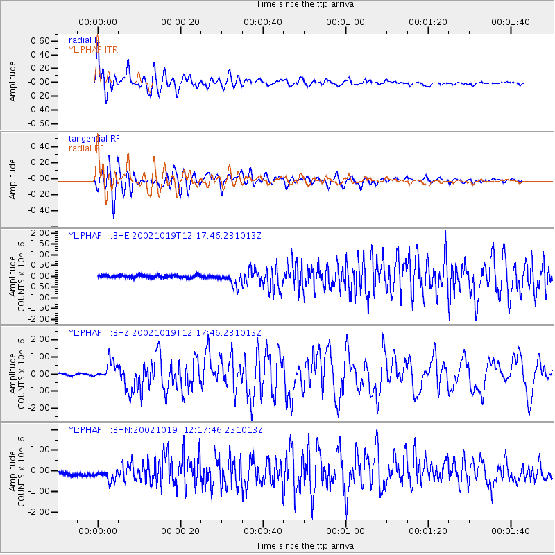
Earthquake location: Kuril Islands
Earthquake latitude/longitude: 44.3/150.0
Earthquake time(UTC): 2002/10/19 (292) 12:09:05 GMT
Earthquake Depth: 33 km
Earthquake Magnitude: 5.4 MB, 6.2 MS, 6.4 MW, 6.1 MW
Earthquake Catalog/Contributor: WHDF/NEIC
Network: YL Himalayan Nepal Tibet Experiment
Station: PHAP YL.PHAP
Lat/Lon: 27.51 N/86.58 E
Elevation: 2488 m
Distance: 52.7 deg
Az: 273.817 deg
Baz: 53.775 deg
Ray Param: 0.066514336
Estimated Moho Depth: 46.75 km
Estimated Crust Vp/Vs: 1.94
Assumed Crust Vp: 6.236 km/s
Estimated Crust Vs: 3.219 km/s
Estimated Crust Poisson's Ratio: 0.32
Radial Match: 88.12396 %
Radial Bump: 400
Transverse Match: 80.57655 %
Transverse Bump: 400
SOD ConfigId: 16844
Insert Time: 2010-02-26 16:02:28.479 +0000
GWidth: 2.5
Max Bumps: 400
Tol: 0.001

Signal To Noise

ChannelStoNSTALTA
YL:PHAP: :BHZ:20021019T12:17:46.231013Z8.3966745.437099E-76.475301E-8
YL:PHAP: :BHN:20021019T12:17:46.231013Z2.04112244.5444213E-72.2264325E-7
YL:PHAP: :BHE:20021019T12:17:46.231013Z5.35946273.1030743E-75.7898983E-8
Arrivals
Ps7.4 SECOND
PpPs21 SECOND
PsPs/PpSs28 SECOND