You are here: Home > Network List > IC - New China Digital Seismograph Network Stations List
> Station HIA Hailar, Neimenggu Autonomous Region, China > Earthquake Result Viewer
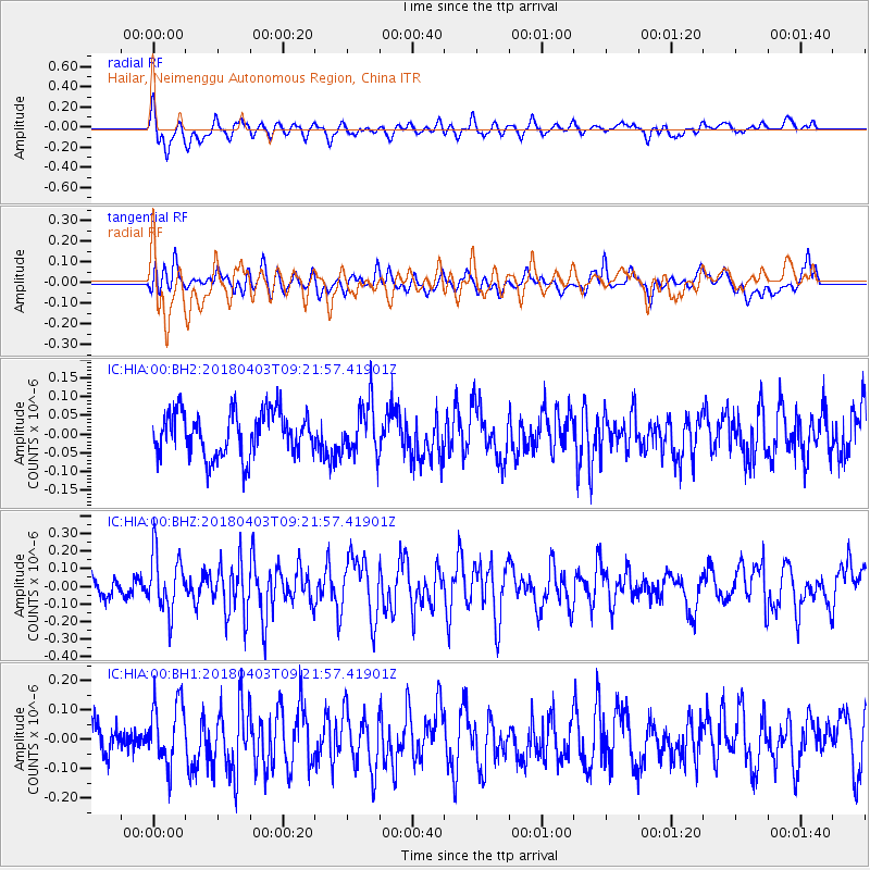
HIA Hailar, Neimenggu Autonomous Region, China - Earthquake Result Viewer
*The percent match for this event was below the threshold and hence no stack was calculated.
| Earthquake location: |
North Of Halmahera, Indonesia |
| Earthquake latitude/longitude: |
3.0/128.0 |
| Earthquake time(UTC): |
2018/04/03 (093) 09:14:06 GMT |
| Earthquake Depth: |
72 km |
| Earthquake Magnitude: |
5.4 Mww |
| Earthquake Catalog/Contributor: |
NEIC PDE/us |
|
| Network: |
IC New China Digital Seismograph Network |
| Station: |
HIA Hailar, Neimenggu Autonomous Region, China |
| Lat/Lon: |
49.27 N/119.74 E |
| Elevation: |
620 m |
|
| Distance: |
46.6 deg |
| Az: |
352.544 deg |
| Baz: |
168.589 deg |
| Ray Param: |
$rayparam |
*The percent match for this event was below the threshold and hence was not used in the summary stack. |
|
| Radial Match: |
73.56192 % |
| Radial Bump: |
400 |
| Transverse Match: |
61.03989 % |
| Transverse Bump: |
400 |
| SOD ConfigId: |
2643891 |
| Insert Time: |
2018-04-17 09:15:41.809 +0000 |
| GWidth: |
2.5 |
| Max Bumps: |
400 |
| Tol: |
0.001 |
|
Signal To Noise
| Channel | StoN | STA | LTA |
| IC:HIA:00:BHZ:20180403T09:21:57.41901Z | 2.210031 | 1.6432193E-7 | 7.4352776E-8 |
| IC:HIA:00:BH1:20180403T09:21:57.41901Z | 2.334706 | 1.0916389E-7 | 4.6757016E-8 |
| IC:HIA:00:BH2:20180403T09:21:57.41901Z | 1.1472865 | 6.724063E-8 | 5.8608396E-8 |
| Arrivals |
| Ps | |
| PpPs | |
| PsPs/PpSs | |


