You are here: Home > Network List > YL01 - Himalayan Nepal Tibet Experiment Stations List
> Station RBSH YL.RBSH > Earthquake Result Viewer
RBSH YL.RBSH - Earthquake Result Viewer

| Earthquake location: |
Eastern Honshu, Japan |
| Earthquake latitude/longitude: |
39.4/141.1 |
| Earthquake time(UTC): |
2001/12/02 (336) 13:01:53 GMT |
| Earthquake Depth: |
124 km |
| Earthquake Magnitude: |
6.1 MB, 6.5 MW, 6.5 MW |
| Earthquake Catalog/Contributor: |
WHDF/NEIC |
|
| Network: |
YL Himalayan Nepal Tibet Experiment |
| Station: |
RBSH YL.RBSH |
| Lat/Lon: |
28.20 N/86.83 E |
| Elevation: |
5100 m |
|
| Distance: |
45.8 deg |
| Az: |
273.055 deg |
| Baz: |
61.229 deg |
| Ray Param: |
0.070590585 |
| Estimated Moho Depth: |
37.25 km |
| Estimated Crust Vp/Vs: |
1.70 |
| Assumed Crust Vp: |
6.514 km/s |
| Estimated Crust Vs: |
3.838 km/s |
| Estimated Crust Poisson's Ratio: |
0.23 |
|
| Radial Match: |
86.403984 % |
| Radial Bump: |
400 |
| Transverse Match: |
79.52895 % |
| Transverse Bump: |
400 |
| SOD ConfigId: |
16820 |
| Insert Time: |
2010-02-26 16:05:17.123 +0000 |
| GWidth: |
2.5 |
| Max Bumps: |
400 |
| Tol: |
0.001 |
|
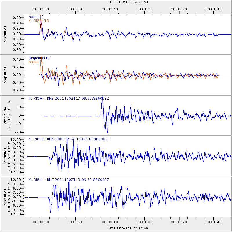
Signal To Noise
| Channel | StoN | STA | LTA |
| YL:RBSH: :BHN:20011202T13:09:32.886003Z | 1.7636163 | 1.0466935E-7 | 5.9349276E-8 |
| YL:RBSH: :BHE:20011202T13:09:32.886003Z | 2.872048 | 1.876792E-7 | 6.5346825E-8 |
| YL:RBSH: :BHZ:20011202T13:09:32.886003Z | 10.096918 | 4.975742E-7 | 4.9279812E-8 |
| Arrivals |
| Ps | 4.3 SECOND |
| PpPs | 14 SECOND |
| PsPs/PpSs | 19 SECOND |


