
Station YL RBSH - YL.RBSH
Network: YL01 - Himalayan Nepal Tibet Experiment
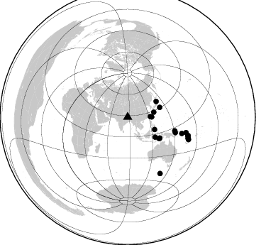
Nearby stations (2 deg radius)
| Station | Name | (Lat, Lon) | Start / End | Elevation |
| RBSH | YL.RBSH | (28.20, 86.83) | 2001-09-07 / 2003-01-01 | 5.1 km |
| Crust2 Type: | RD,orogen/70km Tibet, no seds. |
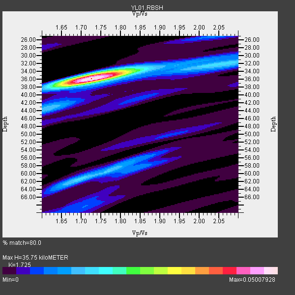
| Thickness Estimate: | 36 km |
| Thickness StdDev: | 0.3 km |
| Vp/Vs Estimate: | 1.73 |
| Vp/Vs StdDev: | 0.01 |
| Vs Estimate: | 3.776 km/s |
| Poisson's Ratio: | 0.25 |
| Peak Value: | 0.05 |
| Assumed Vp: | 6.514 km/s |
| Ps Weight: | 0.33333334 |
| PpPs Weight: | 0.33333334 |
| PsPs Weight: | 0.33333328 |
| Residual Complexity: | 0.444 |
| Nearby stations H: | +- |
| (2.0 deg) Vp/Vs: | +- |
5 with match > 90% ( 26.31579 %) and 19 with match > 80% ( 100.0 %) out of 19.
Download stack as xyz text file.
Azimuth Distribution of Events:
Prior Results for this Station
| Study | Thickness | Vp/Vs | Vp | Vs | Poissons Ratio | Extra |
| EARS | 36 km | 1.73 | 6.514 km/s | 3.776 km/s | 0.25 | |
| Crust2.0 | 70 km | 1.76 | 6.514 km/s | 3.706 km/s | 0.26 | RD,orogen/70km Tibet, no seds. |
| Global Maxima | 36 km | 1.73 | 6.514 km/s | 3.776 km/s | 0.25 | amp=0.05007928 |
| Local Maxima 1 | 61 km | 1.70 | 6.514 km/s | 3.843 km/s | 0.23 | amp=0.015779946 |
| Local Maxima 2 | 34 km | 1.75 | 6.514 km/s | 3.712 km/s | 0.26 | amp=0.015346888 |
| Local Maxima 3 | 44 km | 1.62 | 6.514 km/s | 4.034 km/s | 0.19 | amp=0.011104568 |
| Local Maxima 4 | 58 km | 1.80 | 6.514 km/s | 3.624 km/s | 0.28 | amp=0.010391857 |
| Predicted Arrivals for vertical incidence (zero ray parameter) | |
| Ps | 3.98 SECOND |
| PpPs | 14.95 SECOND |
| PsPs/PpSs | 18.93 SECOND |
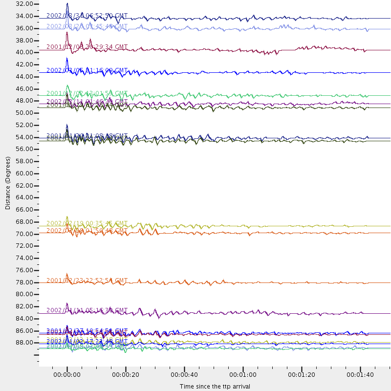
Events Processed for this Station
Download zip of receiver functions as SAC
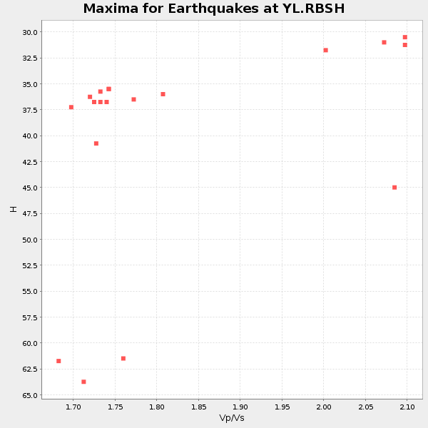
Plot maxima for each earthquake.
Events Used in the Stack
(19 events)| Radial Match | Distance | Baz | FERegion | Time | Lat/Lon | Depth | Magnitude |
| 94.5586 | 90.6 deg | 109.584 deg | Vanuatu Islands | 2002/01/02 17:22:48 GMT | (-17.6, 167.9) | 21 km | 6.3 MB, 7.5 MS, 7.3 MW, 7.1 MW |
| 94.32272 | 79.6 deg | 106.799 deg | Solomon Islands | 2001/12/23 22:52:54 GMT | (-9.6, 159.5) | 16 km | 6.2 MB, 7.0 MS, 6.8 MW, 6.7 MW |
| 90.65839 | 31.9 deg | 88.8 deg | Taiwan Region | 2002/03/31 06:52:50 GMT | (24.3, 122.2) | 33 km | 6.4 MB, 7.4 MS, 7.1 MW, 7.1 MW |
| 90.64734 | 88.9 deg | 106.883 deg | Vanuatu Islands | 2002/04/11 21:56:56 GMT | (-14.4, 167.7) | 10 km | 5.9 MB, 6.2 MS, 6.2 MW, 6.1 MW |
| 90.01432 | 41.7 deg | 114.788 deg | Mindanao, Philippines | 2002/03/05 21:16:09 GMT | (6.0, 124.2) | 31 km | 6.3 MB, 7.2 MS, 7.5 MW, 7.2 MW |
| 88.65477 | 33.8 deg | 89.589 deg | Southwestern Ryukyu Isl., Japan | 2002/03/26 03:45:48 GMT | (23.3, 124.1) | 33 km | 5.8 MB, 6.6 MS, 6.4 MW, 6.4 MW |
| 88.38144 | 69.3 deg | 106.23 deg | New Ireland Region, P.N.G. | 2002/02/19 00:35:45 GMT | (-3.7, 151.0) | 10 km | 5.9 MB, 6.0 MS, 6.1 MW, 6.1 MW |
| 86.403984 | 45.8 deg | 61.229 deg | Eastern Honshu, Japan | 2001/12/02 13:01:53 GMT | (39.4, 141.1) | 124 km | 6.1 MB, 6.5 MW, 6.5 MW |
| 84.9092 | 90.3 deg | 109.291 deg | Vanuatu Islands | 2001/12/12 12:53:18 GMT | (-17.2, 167.7) | 33 km | 6.0 MB, 6.0 MS, 6.2 MW, 6.2 MW |
| 84.24691 | 53.5 deg | 124.142 deg | Banda Sea | 2001/11/20 21:08:18 GMT | (-6.9, 128.9) | 33 km | 5.7 MB, 6.0 MS, 6.3 MW, 6.2 MW |
| 83.948166 | 91.2 deg | 110.243 deg | Vanuatu Islands | 2001/10/26 23:05:50 GMT | (-18.5, 168.1) | 33 km | 5.7 MB, 6.1 MS, 6.1 MW, 6.0 MW |
| 83.628204 | 70.6 deg | 107.83 deg | New Britain Region, P.N.G. | 2002/02/28 01:50:48 GMT | (-5.7, 151.3) | 40 km | 6.0 MB, 6.3 MS, 6.3 MW, 6.2 MW |
| 83.528 | 88.6 deg | 107.306 deg | Vanuatu Islands | 2001/12/27 10:54:51 GMT | (-14.6, 167.3) | 153 km | 5.7 MB, 6.2 MW, 6.1 MW |
| 83.23431 | 54.0 deg | 122.972 deg | Banda Sea | 2002/03/19 22:14:14 GMT | (-6.5, 129.9) | 148 km | 5.7 MB, 6.1 MW, 6.0 MW |
| 83.006256 | 37.5 deg | 79.488 deg | Ryukyu Islands, Japan | 2001/12/08 20:29:34 GMT | (28.3, 129.6) | 33 km | 5.7 MB, 5.7 MS, 6.2 MW, 6.1 MW |
| 82.47576 | 85.0 deg | 104.746 deg | Santa Cruz Islands | 2002/01/11 05:16:30 GMT | (-10.6, 165.3) | 33 km | 5.4 MB, 5.6 MS, 5.8 MW, 5.7 MW |
| 81.93758 | 48.0 deg | 125.989 deg | Banda Sea | 2001/10/19 03:28:44 GMT | (-4.1, 123.9) | 33 km | 6.3 MB, 7.3 MS, 7.5 MW, 7.4 MW |
| 81.77051 | 91.4 deg | 149.978 deg | South Of Australia | 2002/04/08 03:48:55 GMT | (-51.1, 139.3) | 10 km | 5.6 MB, 6.1 MS, 6.2 MW, 6.2 MW |
| 81.06343 | 47.4 deg | 73.16 deg | Southeast Of Honshu, Japan | 2002/03/11 01:46:20 GMT | (30.6, 141.6) | 33 km | 5.9 MB, 5.6 MS, 5.8 MW, 5.7 MW |
Losers
(0 events)| Radial Match | Distance | Baz | FERegion | Time | Lat/Lon | Depth | Magnitude | Reason |
