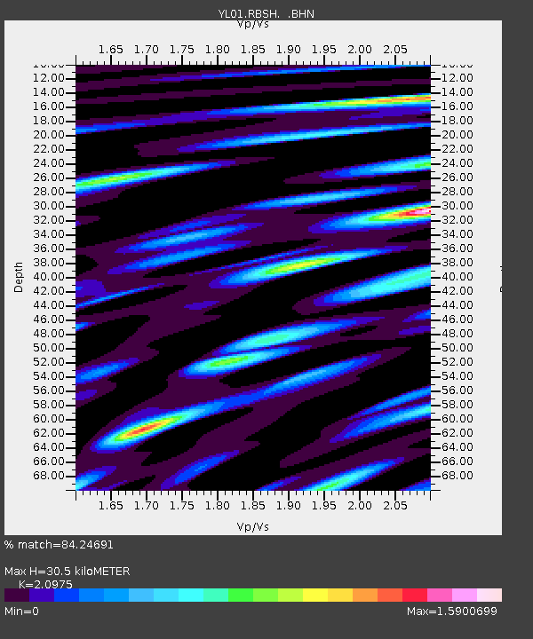
RBSH YL.RBSH - Earthquake Result Viewer
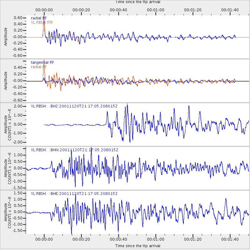
Earthquake location: Banda Sea
Earthquake latitude/longitude: -6.9/128.9
Earthquake time(UTC): 2001/11/20 (324) 21:08:18 GMT
Earthquake Depth: 33 km
Earthquake Magnitude: 5.7 MB, 6.0 MS, 6.3 MW, 6.2 MW
Earthquake Catalog/Contributor: WHDF/NEIC
Network: YL Himalayan Nepal Tibet Experiment
Station: RBSH YL.RBSH
Lat/Lon: 28.20 N/86.83 E
Elevation: 5100 m
Distance: 53.5 deg
Az: 312.629 deg
Baz: 124.142 deg
Ray Param: 0.06597535
Estimated Moho Depth: 30.5 km
Estimated Crust Vp/Vs: 2.10
Assumed Crust Vp: 6.514 km/s
Estimated Crust Vs: 3.106 km/s
Estimated Crust Poisson's Ratio: 0.35
Radial Match: 84.24691 %
Radial Bump: 400
Transverse Match: 74.85671 %
Transverse Bump: 400
SOD ConfigId: 16820
Insert Time: 2010-02-26 16:05:18.626 +0000
GWidth: 2.5
Max Bumps: 400
Tol: 0.001

Signal To Noise

ChannelStoNSTALTA
YL:RBSH: :BHN:20011120T21:17:05.208015Z4.28004461.7564952E-74.1039183E-8
YL:RBSH: :BHE:20011120T21:17:05.208015Z4.27120261.9562476E-74.5800864E-8
YL:RBSH: :BHZ:20011120T21:17:05.208015Z10.9039374.3579283E-73.9966558E-8
Arrivals
Ps5.4 SECOND
PpPs14 SECOND
PsPs/PpSs19 SECOND