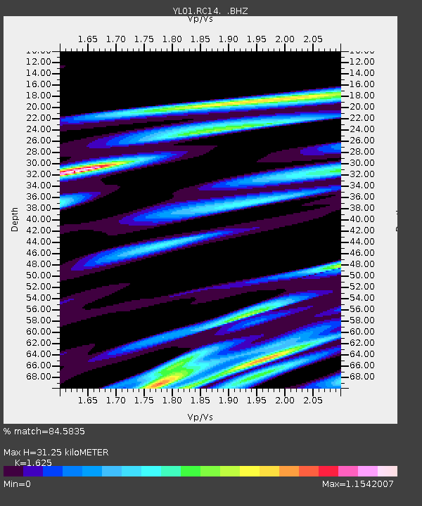
RC14 YL.RC14 - Earthquake Result Viewer

Earthquake location: Solomon Islands
Earthquake latitude/longitude: -10.9/161.2
Earthquake time(UTC): 2002/10/01 (274) 08:46:55 GMT
Earthquake Depth: 10 km
Earthquake Magnitude: 5.7 MB, 5.5 MS, 5.8 MW, 5.6 MW
Earthquake Catalog/Contributor: WHDF/NEIC
Network: YL Himalayan Nepal Tibet Experiment
Station: RC14 YL.RC14
Lat/Lon: 29.50 N/86.44 E
Elevation: 4756 m
Distance: 82.4 deg
Az: 301.934 deg
Baz: 107.056 deg
Ray Param: 0.046928015
Estimated Moho Depth: 31.25 km
Estimated Crust Vp/Vs: 1.62
Assumed Crust Vp: 6.514 km/s
Estimated Crust Vs: 4.009 km/s
Estimated Crust Poisson's Ratio: 0.20
Radial Match: 84.5835 %
Radial Bump: 397
Transverse Match: 74.66261 %
Transverse Bump: 400
SOD ConfigId: 16820
Insert Time: 2010-02-26 16:05:42.909 +0000
GWidth: 2.5
Max Bumps: 400
Tol: 0.001

Signal To Noise

ChannelStoNSTALTA
YL:RC14: :BHZ:20021001T08:58:46.439019Z0.72081734.447811E-86.17051E-8
YL:RC14: :BHN:20021001T08:58:46.439019Z1.09500366.50859E-85.943899E-8
YL:RC14: :BHE:20021001T08:58:46.439019Z0.695699633.0854483E-84.4350294E-8
Arrivals
Ps3.1 SECOND
PpPs12 SECOND
PsPs/PpSs15 SECOND