
Station YL RC14 - YL.RC14
Network: YL01 - Himalayan Nepal Tibet Experiment
Nearby stations (2 deg radius)
| Station | Name | (Lat, Lon) | Start / End | Elevation |
| RC14 | YL.RC14 | (29.50, 86.44) | 2001-09-07 / 2003-01-01 | 4756 m |
| Crust2 Type: | RD,orogen/70km Tibet, no seds. |
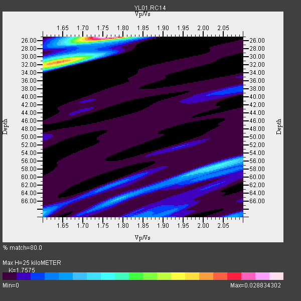
| Thickness Estimate: | 25 km |
| Thickness StdDev: | 5.9 km |
| Vp/Vs Estimate: | 1.76 |
| Vp/Vs StdDev: | 0.06 |
| Vs Estimate: | 3.707 km/s |
| Poisson's Ratio: | 0.26 |
| Peak Value: | 0.03 |
| Assumed Vp: | 6.514 km/s |
| Ps Weight: | 0.33333334 |
| PpPs Weight: | 0.33333334 |
| PsPs Weight: | 0.33333328 |
| Residual Complexity: | 0.725 |
| Nearby stations H: | +- |
| (2.0 deg) Vp/Vs: | +- |
6 with match > 90% ( 23.076923 %) and 16 with match > 80% ( 61.53846 %) out of 26.
Download stack as xyz text file.
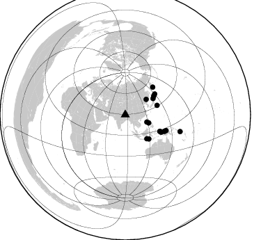
Azimuth Distribution of Events:
Prior Results for this Station
| Study | Thickness | Vp/Vs | Vp | Vs | Poissons Ratio | Extra |
| EARS | 25 km | 1.76 | 6.514 km/s | 3.707 km/s | 0.26 | |
| Crust2.0 | 70 km | 1.76 | 6.514 km/s | 3.706 km/s | 0.26 | RD,orogen/70km Tibet, no seds. |
| Global Maxima | 25 km | 1.76 | 6.514 km/s | 3.707 km/s | 0.26 | amp=0.028834302 |
| Local Maxima 1 | 31 km | 1.64 | 6.514 km/s | 3.978 km/s | 0.20 | amp=0.021047646 |
| Local Maxima 2 | 57 km | 2.04 | 6.514 km/s | 3.189 km/s | 0.34 | amp=0.0114871 |
| Local Maxima 3 | 69 km | 1.60 | 6.514 km/s | 4.071 km/s | 0.18 | amp=0.00838973 |
| Local Maxima 4 | 66 km | 1.79 | 6.514 km/s | 3.649 km/s | 0.27 | amp=0.007003117 |
| Predicted Arrivals for vertical incidence (zero ray parameter) | |
| Ps | 2.91 SECOND |
| PpPs | 10.58 SECOND |
| PsPs/PpSs | 13.49 SECOND |
Events Processed for this Station
Download zip of receiver functions as SAC
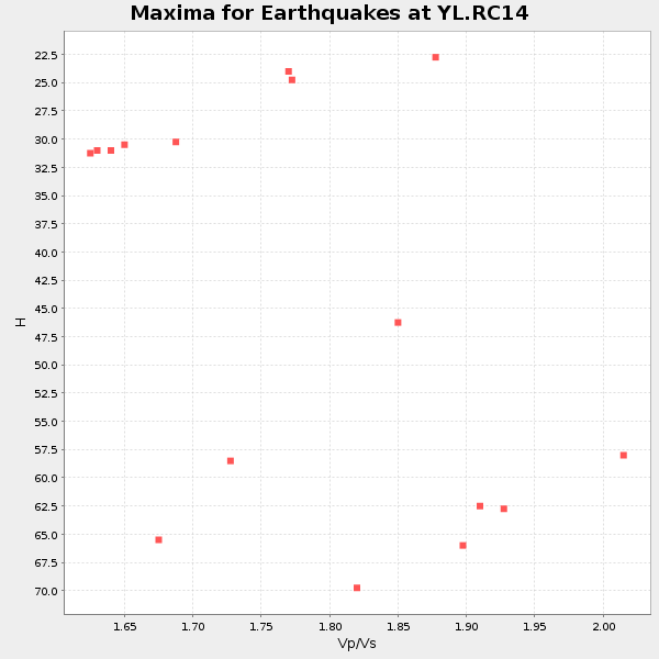
Plot maxima for each earthquake.
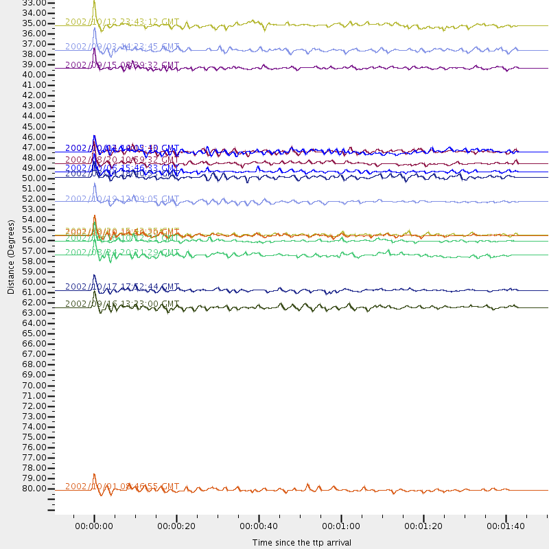
Events Used in the Stack
(16 events)| Radial Match | Distance | Baz | FERegion | Time | Lat/Lon | Depth | Magnitude |
| 95.02789 | 51.7 deg | 55.009 deg | Kuril Islands | 2002/10/19 12:09:05 GMT | (44.3, 150.0) | 33 km | 5.4 MB, 6.2 MS, 6.4 MW, 6.1 MW |
| 94.718094 | 55.8 deg | 44.964 deg | Near East Coast Of Kamchatka | 2002/10/16 10:12:21 GMT | (52.0, 157.3) | 102 km | 6.1 MB, 6.2 MW, 6.2 MW |
| 93.737724 | 55.3 deg | 115.599 deg | Irian Jaya Region, Indonesia | 2002/10/10 10:50:20 GMT | (-1.8, 134.3) | 10 km | 6.5 MB, 7.7 MS, 7.6 MW, 7.4 MW |
| 93.69796 | 55.2 deg | 115.573 deg | Irian Jaya Region, Indonesia | 2002/09/20 15:43:35 GMT | (-1.7, 134.2) | 10 km | 5.9 MB, 6.4 MS, 6.4 MW, 6.3 MW |
| 90.92767 | 48.5 deg | 135.65 deg | Sumbawa Region, Indonesia | 2002/10/06 15:46:33 GMT | (-8.2, 118.3) | 10 km | 5.8 MB, 6.0 MS, 6.2 MW, 6.2 MW |
| 90.25991 | 62.9 deg | 111.192 deg | Near N Coast Of New Guinea, P.N.G. | 2002/09/16 13:23:00 GMT | (-3.3, 142.7) | 10 km | 5.9 MB, 5.9 MS, 6.3 MW, 6.1 MW |
| 88.834816 | 35.5 deg | 109.183 deg | Mindoro, Philippines | 2002/09/03 14:23:45 GMT | (13.5, 120.8) | 10 km | 5.5 MB, 5.4 MS, 5.9 MW, 5.8 MW |
| 88.45884 | 37.4 deg | 53.701 deg | Northeastern China | 2002/09/15 08:39:32 GMT | (44.8, 129.9) | 586 km | 5.8 MB, 6.4 MW, 6.4 MW |
| 87.68501 | 47.6 deg | 73.592 deg | Southeast Of Honshu, Japan | 2002/08/20 10:59:32 GMT | (31.0, 142.0) | 9.0 km | 5.4 MB, 6.2 MS, 6.3 MW, 6.1 MW |
| 85.75568 | 32.8 deg | 108.879 deg | Philippine Islands Region | 2002/10/12 23:43:12 GMT | (15.1, 118.5) | 33 km | 5.6 MB, 5.6 MS, 6.1 MW |
| 85.59952 | 49.0 deg | 56.872 deg | Kuril Islands | 2002/08/24 18:40:53 GMT | (43.1, 146.1) | 43 km | 5.9 MB, 5.8 MS, 6.2 MW, 6.1 MW |
| 84.5835 | 82.4 deg | 107.056 deg | Solomon Islands | 2002/10/01 08:46:55 GMT | (-10.9, 161.2) | 10 km | 5.7 MB, 5.5 MS, 5.8 MW, 5.6 MW |
| 84.25881 | 57.4 deg | 115.919 deg | Irian Jaya Region, Indonesia | 2002/08/24 20:21:29 GMT | (-3.3, 135.8) | 33 km | 5.5 MB, 5.5 MS, 5.8 MW, 5.7 MW |
| 83.42325 | 46.3 deg | 59.765 deg | Hokkaido, Japan Region | 2002/10/14 14:12:43 GMT | (41.2, 142.2) | 61 km | 5.9 MB, 6.1 MW, 6.1 MW |
| 82.448105 | 61.1 deg | 113.081 deg | Irian Jaya, Indonesia | 2002/10/17 17:52:44 GMT | (-3.6, 140.2) | 33 km | 5.6 MB, 6.2 MS, 6.3 MW, 6.3 MW |
| 82.172104 | 46.3 deg | 137.982 deg | Bali Sea | 2002/10/03 19:05:10 GMT | (-7.5, 115.7) | 316 km | 6.0 MB, 6.0 MW, 6.0 MW |
Losers
(10 events)| Radial Match | Distance | Baz | FERegion | Time | Lat/Lon | Depth | Magnitude | Reason |
| 80.92443 | 55.0 deg | 115.46 deg | Irian Jaya Region, Indonesia | 2002/10/10 18:33:37 GMT | (-1.5, 134.1) | 10 km | 5.5 MS, 5.4 MB | |
| 79.830185 | 45.4 deg | 76.705 deg | Southeast Of Honshu, Japan | 2002/08/02 23:11:39 GMT | (29.3, 139.0) | 426 km | 5.5 MB, 6.3 MW, 6.3 MW | |
| 76.30723 | 82.6 deg | 106.971 deg | Solomon Islands | 2002/10/03 04:26:06 GMT | (-11.0, 161.4) | 10 km | 5.6 MB, 5.6 MS, 5.9 MW, 5.7 MW | |
| 74.70032 | 93.1 deg | 109.642 deg | Vanuatu Islands | 2002/10/07 19:00:31 GMT | (-18.7, 169.3) | 246 km | 5.4 MB, 5.7 MW, 5.6 MW | |
| 74.143456 | 40.5 deg | 149.71 deg | Sunda Strait, Indonesia | 2002/08/26 14:55:13 GMT | (-6.8, 105.7) | 63 km | 5.6 MB, 5.8 MW, 5.7 MW | |
| 69.63277 | 35.2 deg | 252.065 deg | Eastern Gulf Of Aden | 2002/09/01 17:14:59 GMT | (14.3, 51.9) | 10 km | 5.8 MS, 5.2 MB, 6.0 MW, 6.0 MW | |
| 63.393898 | 49.5 deg | 136.244 deg | Sumbawa Region, Indonesia | 2002/07/24 03:05:05 GMT | (-9.3, 118.6) | 29 km | 5.8 MB, 5.4 MS, 5.9 MW, 5.9 MW | |
| 60.892303 | 61.2 deg | 113.087 deg | Irian Jaya, Indonesia | 2002/10/19 00:43:56 GMT | (-3.7, 140.3) | 33 km | 5.3 MB, 5.9 MS, 6.1 MW, 6.0 MW | |
| 41.95781 | 55.3 deg | 123.103 deg | Banda Sea | 2002/07/30 20:02:06 GMT | (-6.5, 130.3) | 103 km | 5.5 MW, 5.4 MB, 5.3 MW | |
| 40.848705 | 32.0 deg | 89.072 deg | Taiwan Region | 2002/09/16 00:03:29 GMT | (25.2, 122.3) | 183 km | 5.6 MW, 5.3 MB, 5.5 MW |
