You are here: Home > Network List > YL01 - Himalayan Nepal Tibet Experiment Stations List
> Station RC14 YL.RC14 > Earthquake Result Viewer
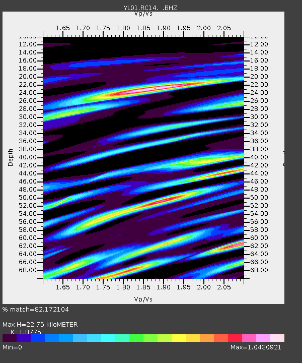
RC14 YL.RC14 - Earthquake Result Viewer
| Earthquake location: |
Bali Sea |
| Earthquake latitude/longitude: |
-7.5/115.7 |
| Earthquake time(UTC): |
2002/10/03 (276) 19:05:10 GMT |
| Earthquake Depth: |
316 km |
| Earthquake Magnitude: |
6.0 MB, 6.0 MW, 6.0 MW |
| Earthquake Catalog/Contributor: |
WHDF/NEIC |
|
| Network: |
YL Himalayan Nepal Tibet Experiment |
| Station: |
RC14 YL.RC14 |
| Lat/Lon: |
29.50 N/86.44 E |
| Elevation: |
4756 m |
|
| Distance: |
46.3 deg |
| Az: |
323.946 deg |
| Baz: |
137.982 deg |
| Ray Param: |
0.069429755 |
| Estimated Moho Depth: |
22.75 km |
| Estimated Crust Vp/Vs: |
1.88 |
| Assumed Crust Vp: |
6.514 km/s |
| Estimated Crust Vs: |
3.47 km/s |
| Estimated Crust Poisson's Ratio: |
0.30 |
|
| Radial Match: |
82.172104 % |
| Radial Bump: |
400 |
| Transverse Match: |
73.690674 % |
| Transverse Bump: |
400 |
| SOD ConfigId: |
16844 |
| Insert Time: |
2010-02-26 16:05:55.993 +0000 |
| GWidth: |
2.5 |
| Max Bumps: |
400 |
| Tol: |
0.001 |
|

Signal To Noise
| Channel | StoN | STA | LTA |
| YL:RC14: :BHZ:20021003T19:12:35.189012Z | 25.815487 | 1.7894772E-6 | 6.931797E-8 |
| YL:RC14: :BHN:20021003T19:12:35.189012Z | 6.2673397 | 4.146873E-7 | 6.61664E-8 |
| YL:RC14: :BHE:20021003T19:12:35.189012Z | 7.1130114 | 6.0698216E-7 | 8.5334065E-8 |
| Arrivals |
| Ps | 3.2 SECOND |
| PpPs | 9.5 SECOND |
| PsPs/PpSs | 13 SECOND |


