You are here: Home > Network List > YL01 - Himalayan Nepal Tibet Experiment Stations List
> Station RC14 YL.RC14 > Earthquake Result Viewer
RC14 YL.RC14 - Earthquake Result Viewer
| Earthquake location: |
Philippine Islands Region |
| Earthquake latitude/longitude: |
15.1/118.5 |
| Earthquake time(UTC): |
2002/10/12 (285) 23:43:12 GMT |
| Earthquake Depth: |
33 km |
| Earthquake Magnitude: |
5.6 MB, 5.6 MS, 6.1 MW |
| Earthquake Catalog/Contributor: |
WHDF/NEIC |
|
| Network: |
YL Himalayan Nepal Tibet Experiment |
| Station: |
RC14 YL.RC14 |
| Lat/Lon: |
29.50 N/86.44 E |
| Elevation: |
4756 m |
|
| Distance: |
32.8 deg |
| Az: |
301.352 deg |
| Baz: |
108.879 deg |
| Ray Param: |
0.07843985 |
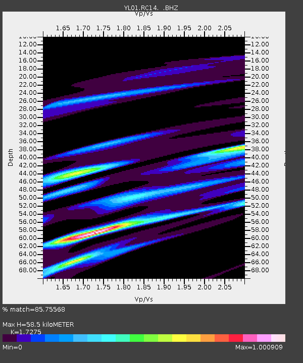
| Estimated Moho Depth: |
58.5 km |
| Estimated Crust Vp/Vs: |
1.73 |
| Assumed Crust Vp: |
6.514 km/s |
| Estimated Crust Vs: |
3.771 km/s |
| Estimated Crust Poisson's Ratio: |
0.25 |
|
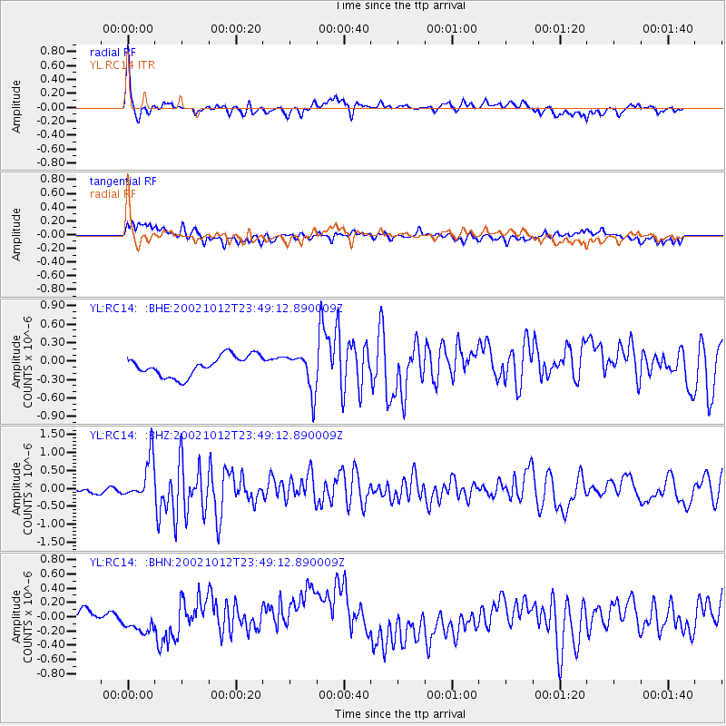
| Radial Match: |
85.75568 % |
| Radial Bump: |
330 |
| Transverse Match: |
47.024467 % |
| Transverse Bump: |
389 |
| SOD ConfigId: |
16844 |
| Insert Time: |
2010-02-26 16:05:58.859 +0000 |
| GWidth: |
2.5 |
| Max Bumps: |
400 |
| Tol: |
0.001 |
|
Signal To Noise
| Channel | StoN | STA | LTA |
| YL:RC14: :BHZ:20021012T23:49:12.890009Z | 6.6075993 | 5.7865475E-7 | 8.7574136E-8 |
| YL:RC14: :BHN:20021012T23:49:12.890009Z | 1.996521 | 1.9289743E-7 | 9.661678E-8 |
| YL:RC14: :BHE:20021012T23:49:12.890009Z | 1.886522 | 3.1004842E-7 | 1.6434922E-7 |
| Arrivals |
| Ps | 7.1 SECOND |
| PpPs | 23 SECOND |
| PsPs/PpSs | 30 SECOND |


