You are here: Home > Network List > YL01 - Himalayan Nepal Tibet Experiment Stations List
> Station RC14 YL.RC14 > Earthquake Result Viewer
RC14 YL.RC14 - Earthquake Result Viewer
| Earthquake location: |
Near East Coast Of Kamchatka |
| Earthquake latitude/longitude: |
52.0/157.3 |
| Earthquake time(UTC): |
2002/10/16 (289) 10:12:21 GMT |
| Earthquake Depth: |
102 km |
| Earthquake Magnitude: |
6.1 MB, 6.2 MW, 6.2 MW |
| Earthquake Catalog/Contributor: |
WHDF/NEIC |
|
| Network: |
YL Himalayan Nepal Tibet Experiment |
| Station: |
RC14 YL.RC14 |
| Lat/Lon: |
29.50 N/86.44 E |
| Elevation: |
4756 m |
|
| Distance: |
55.8 deg |
| Az: |
275.475 deg |
| Baz: |
44.964 deg |
| Ray Param: |
0.06422078 |
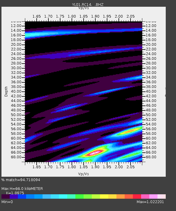
| Estimated Moho Depth: |
66.0 km |
| Estimated Crust Vp/Vs: |
1.90 |
| Assumed Crust Vp: |
6.514 km/s |
| Estimated Crust Vs: |
3.433 km/s |
| Estimated Crust Poisson's Ratio: |
0.31 |
|
| Radial Match: |
94.718094 % |
| Radial Bump: |
305 |
| Transverse Match: |
82.667694 % |
| Transverse Bump: |
400 |
| SOD ConfigId: |
16844 |
| Insert Time: |
2010-02-26 16:06:01.673 +0000 |
| GWidth: |
2.5 |
| Max Bumps: |
400 |
| Tol: |
0.001 |
|

Signal To Noise
| Channel | StoN | STA | LTA |
| YL:RC14: :BHZ:20021016T10:21:17.614021Z | 45.245106 | 2.1231583E-6 | 4.6925702E-8 |
| YL:RC14: :BHN:20021016T10:21:17.614021Z | 3.9912512 | 5.3017135E-7 | 1.3283336E-7 |
| YL:RC14: :BHE:20021016T10:21:17.614021Z | 9.53918 | 7.655806E-7 | 8.0256434E-8 |
| Arrivals |
| Ps | 9.5 SECOND |
| PpPs | 28 SECOND |
| PsPs/PpSs | 38 SECOND |


