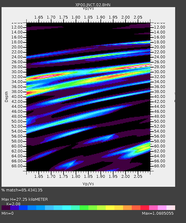
JNCT JNCT - Earthquake Result Viewer

Earthquake location: Irian Jaya Region, Indonesia
Earthquake latitude/longitude: -3.8/135.1
Earthquake time(UTC): 2002/12/11 (345) 03:49:40 GMT
Earthquake Depth: 10 km
Earthquake Magnitude: 5.8 MB, 6.0 MS, 6.3 MW, 6.3 MW
Earthquake Catalog/Contributor: WHDF/NEIC
Network: XP Trans Antarctic Mountain Seismic Experiment
Station: JNCT JNCT
Lat/Lon: 76.93 S/157.90 E
Elevation: 2129 m
Distance: 74.1 deg
Az: 174.744 deg
Baz: 336.319 deg
Ray Param: 0.05254768
Estimated Moho Depth: 27.25 km
Estimated Crust Vp/Vs: 2.08
Assumed Crust Vp: 6.306 km/s
Estimated Crust Vs: 3.031 km/s
Estimated Crust Poisson's Ratio: 0.35
Radial Match: 85.434135 %
Radial Bump: 278
Transverse Match: 73.29286 %
Transverse Bump: 400
SOD ConfigId: 16820
Insert Time: 2010-03-09 13:43:22.294 +0000
GWidth: 2.5
Max Bumps: 400
Tol: 0.001

Signal To Noise

ChannelStoNSTALTA
XP:JNCT:02:BHN:20021211T04:00:45.262021Z2.3777032.2985728E-79.6672E-8
XP:JNCT:02:BHE:20021211T04:00:45.262021Z0.488801155.883388E-81.2036362E-7
XP:JNCT:02:BHZ:20021211T04:00:45.262021Z1.96262922.126624E-71.0835587E-7
Arrivals
Ps4.8 SECOND
PpPs13 SECOND
PsPs/PpSs18 SECOND