
Station XP JNCT - JNCT
Network: XP00 - Trans Antarctic Mountain Seismic Experiment
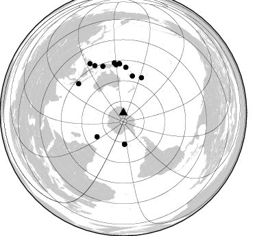
Nearby stations (2 deg radius)
| Station | Name | (Lat, Lon) | Start / End | Elevation |
| JNCT | JNCT | (-76.93, 157.90) | 2000-12-11 / 2003-12-31 | 2.1 km |
| Crust2 Type: | O4,Orogen/40 km 1.5 ice |
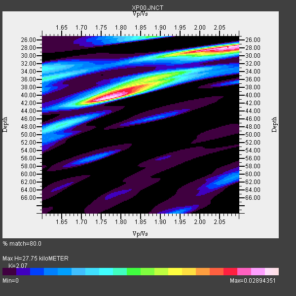
| Thickness Estimate: | 28 km |
| Thickness StdDev: | 6.0 km |
| Vp/Vs Estimate: | 2.07 |
| Vp/Vs StdDev: | 0.16 |
| Vs Estimate: | 3.046 km/s |
| Poisson's Ratio: | 0.35 |
| Peak Value: | 0.03 |
| Assumed Vp: | 6.306 km/s |
| Ps Weight: | 0.33333334 |
| PpPs Weight: | 0.33333334 |
| PsPs Weight: | 0.33333328 |
| Residual Complexity: | 0.789 |
| Nearby stations H: | +- |
| (2.0 deg) Vp/Vs: | +- |
5 with match > 90% ( 35.714287 %) and 14 with match > 80% ( 100.0 %) out of 14.
Download stack as xyz text file.
Azimuth Distribution of Events:
Prior Results for this Station
| Study | Thickness | Vp/Vs | Vp | Vs | Poissons Ratio | Extra |
| EARS | 28 km | 2.07 | 6.306 km/s | 3.046 km/s | 0.35 | |
| Crust2.0 | 39 km | 1.76 | 6.306 km/s | 3.591 km/s | 0.26 | O4,Orogen/40 km 1.5 ice |
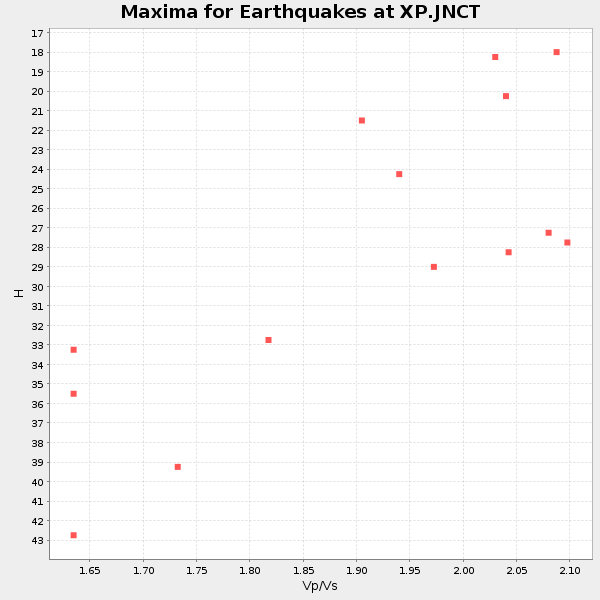
| Global Maxima | 28 km | 2.07 | 6.306 km/s | 3.046 km/s | 0.35 | amp=0.02894351 |
| Local Maxima 1 | 40 km | 1.77 | 6.306 km/s | 3.562 km/s | 0.27 | amp=0.028252264 |
| Local Maxima 2 | 38 km | 1.84 | 6.306 km/s | 3.427 km/s | 0.29 | amp=0.01819814 |
| Local Maxima 3 | 25 km | 1.88 | 6.306 km/s | 3.35 km/s | 0.30 | amp=0.014347366 |
| Local Maxima 4 | 28 km | 2.09 | 6.306 km/s | 3.017 km/s | 0.35 | amp=0.011514525 |
| Predicted Arrivals for vertical incidence (zero ray parameter) | |
| Ps | 4.71 SECOND |
| PpPs | 13.51 SECOND |
| PsPs/PpSs | 18.22 SECOND |
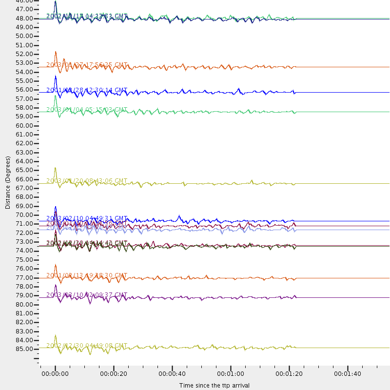
Events Processed for this Station
Download zip of receiver functions as SAC
Plot maxima for each earthquake.
Events Used in the Stack
(14 events)| Radial Match | Distance | Baz | FERegion | Time | Lat/Lon | Depth | Magnitude |
| 95.060745 | 78.0 deg | 303.056 deg | Southern Sumatra, Indonesia | 2001/02/13 19:28:30 GMT | (-4.7, 102.6) | 36 km | 6.2 MB, 7.2 MS, 7.4 MW, 7.0 ME |
| 94.70882 | 66.4 deg | 3.079 deg | Solomon Islands | 2003/01/20 08:43:06 GMT | (-10.5, 160.8) | 33 km | 6.7 MB, 7.8 MS, 7.3 MW, 7.2 MW |
| 94.14009 | 80.4 deg | 328.925 deg | Halmahera, Indonesia | 2003/03/10 02:09:37 GMT | (1.7, 127.3) | 94 km | 6.2 MB, 6.4 MW, 6.4 MW |
| 93.569214 | 57.7 deg | 27.296 deg | Fiji Islands Region | 2003/01/04 05:15:03 GMT | (-20.6, -177.7) | 378 km | 6.0 MB, 6.5 MW, 6.5 MW |
| 92.53915 | 72.1 deg | 355.156 deg | New Ireland Region, P.N.G. | 2002/12/12 08:30:42 GMT | (-4.8, 153.3) | 34 km | 5.9 MB, 6.7 MS, 6.7 MW, 6.6 MW |
| 89.27559 | 74.0 deg | 349.651 deg | Bismarck Sea | 2002/12/20 14:14:42 GMT | (-3.1, 147.9) | 33 km | 5.8 MB, 6.4 MS, 6.3 MW, 6.3 MW |
| 89.186516 | 71.6 deg | 355.592 deg | New Ireland Region, P.N.G. | 2003/01/10 13:11:56 GMT | (-5.3, 153.7) | 72 km | 5.9 MB, 6.7 MW, 6.6 MW |
| 88.089806 | 46.4 deg | 177.937 deg | South Sandwich Islands Region | 2002/12/17 04:32:53 GMT | (-57.0, -24.8) | 10 km | 5.4 MB, 6.3 MS, 6.2 MW, 6.0 MW |
| 87.66593 | 86.5 deg | 325.765 deg | Mindanao, Philippines | 2002/12/30 04:49:08 GMT | (7.5, 123.4) | 10 km | 5.9 MB, 6.2 MS, 6.3 MW, 6.2 MW |
| 85.434135 | 74.1 deg | 336.319 deg | Irian Jaya Region, Indonesia | 2002/12/11 03:49:40 GMT | (-3.8, 135.1) | 10 km | 5.8 MB, 6.0 MS, 6.3 MW, 6.3 MW |
| 82.81274 | 55.3 deg | 13.917 deg | Southeast Of Loyalty Islands | 2001/02/28 12:30:14 GMT | (-22.0, 170.2) | 10 km | 6.0 MB, 6.5 MS, 6.7 MW, 6.5 MW |
| 82.50002 | 46.2 deg | 177.822 deg | South Sandwich Islands Region | 2002/12/18 14:12:21 GMT | (-57.1, -25.0) | 10 km | 5.5 MB, 6.0 MS, 6.2 MW, 5.9 MW |
| 81.6845 | 71.0 deg | 351.468 deg | New Britain Region, P.N.G. | 2003/02/10 04:49:31 GMT | (-6.0, 149.8) | 33 km | 5.6 MB, 6.3 MS, 6.3 MW, 6.2 MW |
| 81.21491 | 52.2 deg | 227.771 deg | Prince Edward Islands Region | 2003/01/27 17:56:25 GMT | (-46.0, 35.1) | 10 km | 5.6 MB, 6.3 MS, 6.5 MW, 6.4 MW |
Losers
(0 events)| Radial Match | Distance | Baz | FERegion | Time | Lat/Lon | Depth | Magnitude | Reason |
