You are here: Home > Network List > XP00 - Trans Antarctic Mountain Seismic Experiment Stations List
> Station N076 N076 > Earthquake Result Viewer
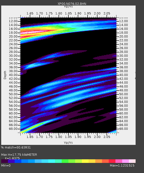
N076 N076 - Earthquake Result Viewer
| Earthquake location: |
Minahassa Peninsula, Sulawesi |
| Earthquake latitude/longitude: |
-0.0/122.9 |
| Earthquake time(UTC): |
2001/12/09 (343) 18:15:02 GMT |
| Earthquake Depth: |
156 km |
| Earthquake Magnitude: |
5.7 MB, 6.2 MW, 6.0 MW |
| Earthquake Catalog/Contributor: |
WHDF/NEIC |
|
| Network: |
XP Trans Antarctic Mountain Seismic Experiment |
| Station: |
N076 N076 |
| Lat/Lon: |
80.81 S/135.43 E |
| Elevation: |
2477 m |
|
| Distance: |
81.0 deg |
| Az: |
177.97 deg |
| Baz: |
347.276 deg |
| Ray Param: |
0.04753966 |
| Estimated Moho Depth: |
17.75 km |
| Estimated Crust Vp/Vs: |
1.64 |
| Assumed Crust Vp: |
6.292 km/s |
| Estimated Crust Vs: |
3.842 km/s |
| Estimated Crust Poisson's Ratio: |
0.20 |
|
| Radial Match: |
80.63931 % |
| Radial Bump: |
400 |
| Transverse Match: |
70.672 % |
| Transverse Bump: |
400 |
| SOD ConfigId: |
16820 |
| Insert Time: |
2010-03-09 13:43:40.068 +0000 |
| GWidth: |
2.5 |
| Max Bumps: |
400 |
| Tol: |
0.001 |
|

Signal To Noise
| Channel | StoN | STA | LTA |
| XP:N076:02:BHN:20011209T18:26:28.62002Z | 4.8210506 | 8.135523E-7 | 1.6874999E-7 |
| XP:N076:02:BHE:20011209T18:26:28.62002Z | 1.1634468 | 2.4652834E-7 | 2.118948E-7 |
| XP:N076:02:BHZ:20011209T18:26:28.62002Z | 15.6323595 | 3.5523665E-6 | 2.2724441E-7 |
| Arrivals |
| Ps | 1.8 SECOND |
| PpPs | 7.2 SECOND |
| PsPs/PpSs | 9.1 SECOND |


