
Station XP N076 - N076
Network: XP00 - Trans Antarctic Mountain Seismic Experiment
Nearby stations (2 deg radius)
| Station | Name | (Lat, Lon) | Start / End | Elevation |
| N076 | N076 | (-80.81, 135.43) | 2001-12-08 / 2003-12-31 | 2.5 km |
| Crust2 Type: | F6,Archean 2.5 km ice, no seds. |
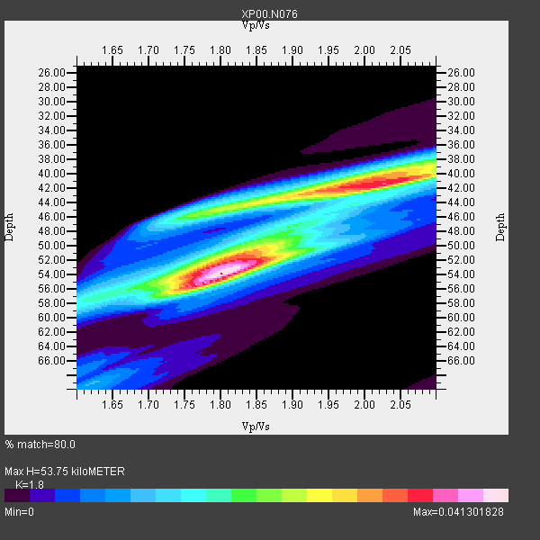
| Thickness Estimate: | 54 km |
| Thickness StdDev: | 5.8 km |
| Vp/Vs Estimate: | 1.80 |
| Vp/Vs StdDev: | 0.11 |
| Vs Estimate: | 3.495 km/s |
| Poisson's Ratio: | 0.28 |
| Peak Value: | 0.04 |
| Assumed Vp: | 6.292 km/s |
| Ps Weight: | 0.33333334 |
| PpPs Weight: | 0.33333334 |
| PsPs Weight: | 0.33333328 |
| Residual Complexity: | 0.768 |
| Nearby stations H: | +- |
| (2.0 deg) Vp/Vs: | +- |
11 with match > 90% ( 61.11111 %) and 18 with match > 80% ( 100.0 %) out of 18.
Download stack as xyz text file.
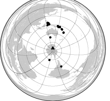
Azimuth Distribution of Events:
Prior Results for this Station
| Study | Thickness | Vp/Vs | Vp | Vs | Poissons Ratio | Extra |
| EARS | 54 km | 1.80 | 6.292 km/s | 3.495 km/s | 0.28 | |
| Crust2.0 | 40 km | 1.77 | 6.292 km/s | 3.556 km/s | 0.27 | F6,Archean 2.5 km ice, no seds. |
| Global Maxima | 54 km | 1.80 | 6.292 km/s | 3.495 km/s | 0.28 | amp=0.041301828 |
| Local Maxima 1 | 41 km | 2.00 | 6.292 km/s | 3.142 km/s | 0.33 | amp=0.03400644 |
| Local Maxima 2 | 45 km | 1.81 | 6.292 km/s | 3.476 km/s | 0.28 | amp=0.020793308 |
| Local Maxima 3 | 51 km | 1.86 | 6.292 km/s | 3.378 km/s | 0.30 | amp=0.018921902 |
| Local Maxima 4 | 39 km | 2.09 | 6.292 km/s | 3.014 km/s | 0.35 | amp=0.015817208 |
| Predicted Arrivals for vertical incidence (zero ray parameter) | |
| Ps | 6.83 SECOND |
| PpPs | 23.92 SECOND |
| PsPs/PpSs | 30.75 SECOND |
Events Processed for this Station
Download zip of receiver functions as SAC
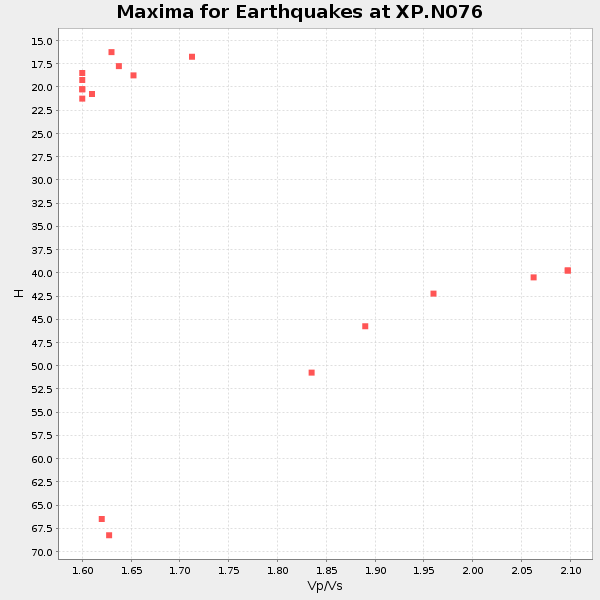
Plot maxima for each earthquake.
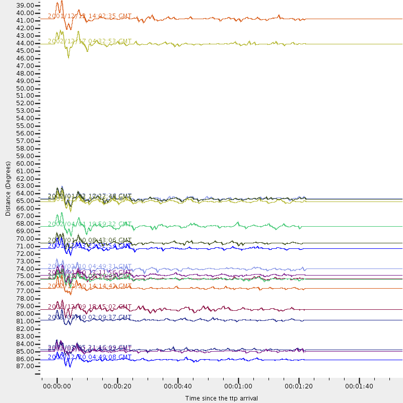
Events Used in the Stack
(18 events)| Radial Match | Distance | Baz | FERegion | Time | Lat/Lon | Depth | Magnitude |
| 98.10763 | 71.2 deg | 26.389 deg | Solomon Islands | 2003/01/20 08:43:06 GMT | (-10.5, 160.8) | 33 km | 6.7 MB, 7.8 MS, 7.3 MW, 7.2 MW |
| 96.93688 | 72.0 deg | 25.04 deg | Solomon Islands | 2001/12/23 22:52:54 GMT | (-9.6, 159.5) | 16 km | 6.2 MB, 7.0 MS, 6.8 MW, 6.7 MW |
| 96.71887 | 86.9 deg | 348.861 deg | Mindanao, Philippines | 2002/03/05 21:16:09 GMT | (6.0, 124.2) | 31 km | 6.3 MB, 7.2 MS, 7.5 MW, 7.2 MW |
| 96.52218 | 64.8 deg | 34.419 deg | Vanuatu Islands | 2002/01/02 17:22:48 GMT | (-17.6, 167.9) | 21 km | 6.3 MB, 7.5 MS, 7.3 MW, 7.1 MW |
| 96.38946 | 76.4 deg | 18.305 deg | New Ireland Region, P.N.G. | 2002/12/12 08:30:42 GMT | (-4.8, 153.3) | 34 km | 5.9 MB, 6.7 MS, 6.7 MW, 6.6 MW |
| 94.90923 | 42.0 deg | 196.044 deg | South Sandwich Islands Region | 2002/12/17 04:32:53 GMT | (-57.0, -24.8) | 10 km | 5.4 MB, 6.3 MS, 6.2 MW, 6.0 MW |
| 93.17133 | 38.3 deg | 347.215 deg | South Of Australia | 2001/12/12 14:02:35 GMT | (-42.8, 124.7) | 10 km | 6.5 MB, 6.7 MS, 7.1 MW, 7.0 MW |
| 92.11842 | 77.9 deg | 12.779 deg | Bismarck Sea | 2002/12/20 14:14:42 GMT | (-3.1, 147.9) | 33 km | 5.8 MB, 6.4 MS, 6.3 MW, 6.3 MW |
| 91.383736 | 64.7 deg | 34.581 deg | Vanuatu Islands | 2002/01/03 10:17:36 GMT | (-17.7, 168.0) | 10 km | 5.8 MB, 6.4 MS, 6.7 MW, 6.4 MW |
| 90.83031 | 65.2 deg | 34.235 deg | Vanuatu Islands | 2001/12/12 12:53:18 GMT | (-17.2, 167.7) | 33 km | 6.0 MB, 6.0 MS, 6.2 MW, 6.2 MW |
| 90.52323 | 75.9 deg | 18.769 deg | New Ireland Region, P.N.G. | 2003/01/10 13:11:56 GMT | (-5.3, 153.7) | 72 km | 5.9 MB, 6.7 MW, 6.6 MW |
| 89.91624 | 76.5 deg | 18.262 deg | New Ireland Region, P.N.G. | 2003/03/11 07:27:32 GMT | (-4.7, 153.2) | 40 km | 6.0 MB, 6.8 MS, 6.8 MW, 6.6 MW |
| 88.11507 | 87.1 deg | 350.263 deg | Mindanao, Philippines | 2002/01/01 11:29:22 GMT | (6.3, 125.7) | 138 km | 5.9 MB, 6.3 MW, 6.3 MW |
| 86.91443 | 75.1 deg | 14.788 deg | New Britain Region, P.N.G. | 2003/02/10 04:49:31 GMT | (-6.0, 149.8) | 33 km | 5.6 MB, 6.3 MS, 6.3 MW, 6.2 MW |
| 86.35405 | 88.4 deg | 348.07 deg | Mindanao, Philippines | 2002/12/30 04:49:08 GMT | (7.5, 123.4) | 10 km | 5.9 MB, 6.2 MS, 6.3 MW, 6.2 MW |
| 86.16014 | 68.8 deg | 155.098 deg | Near Coast Of Central Chile | 2002/04/01 19:59:32 GMT | (-29.7, -71.4) | 71 km | 6.1 MB, 6.4 MW, 6.4 MW |
| 81.434586 | 82.5 deg | 351.795 deg | Halmahera, Indonesia | 2003/03/10 02:09:37 GMT | (1.7, 127.3) | 94 km | 6.2 MB, 6.4 MW, 6.4 MW |
| 80.63931 | 81.0 deg | 347.276 deg | Minahassa Peninsula, Sulawesi | 2001/12/09 18:15:02 GMT | (-0.0, 122.9) | 156 km | 5.7 MB, 6.2 MW, 6.0 MW |
Losers
(0 events)| Radial Match | Distance | Baz | FERegion | Time | Lat/Lon | Depth | Magnitude | Reason |
