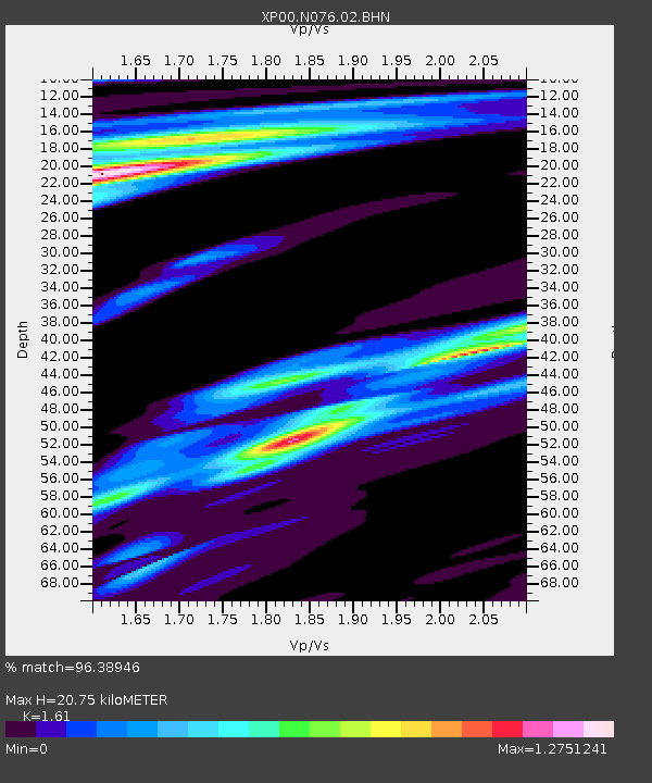
N076 N076 - Earthquake Result Viewer

Earthquake location: New Ireland Region, P.N.G.
Earthquake latitude/longitude: -4.8/153.3
Earthquake time(UTC): 2002/12/12 (346) 08:30:42 GMT
Earthquake Depth: 34 km
Earthquake Magnitude: 5.9 MB, 6.7 MS, 6.7 MW, 6.6 MW
Earthquake Catalog/Contributor: WHDF/NEIC
Network: XP Trans Antarctic Mountain Seismic Experiment
Station: N076 N076
Lat/Lon: 80.81 S/135.43 E
Elevation: 2477 m
Distance: 76.4 deg
Az: 182.905 deg
Baz: 18.305 deg
Ray Param: 0.050940234
Estimated Moho Depth: 20.75 km
Estimated Crust Vp/Vs: 1.61
Assumed Crust Vp: 6.292 km/s
Estimated Crust Vs: 3.908 km/s
Estimated Crust Poisson's Ratio: 0.19
Radial Match: 96.38946 %
Radial Bump: 279
Transverse Match: 94.77099 %
Transverse Bump: 378
SOD ConfigId: 16820
Insert Time: 2010-03-09 13:43:45.515 +0000
GWidth: 2.5
Max Bumps: 400
Tol: 0.001

Signal To Noise

ChannelStoNSTALTA
XP:N076:02:BHN:20021212T08:41:57.967021Z4.5559587.6929456E-71.6885463E-7
XP:N076:02:BHE:20021212T08:41:57.967021Z1.26193132.4344146E-71.9291181E-7
XP:N076:02:BHZ:20021212T08:41:57.967021Z24.1093883.5673588E-61.4796555E-7
Arrivals
Ps2.1 SECOND
PpPs8.3 SECOND
PsPs/PpSs10 SECOND