You are here: Home > Network List > XP00 - Trans Antarctic Mountain Seismic Experiment Stations List
> Station N076 N076 > Earthquake Result Viewer
N076 N076 - Earthquake Result Viewer
| Earthquake location: |
New Ireland Region, P.N.G. |
| Earthquake latitude/longitude: |
-5.3/153.7 |
| Earthquake time(UTC): |
2003/01/10 (010) 13:11:56 GMT |
| Earthquake Depth: |
72 km |
| Earthquake Magnitude: |
5.9 MB, 6.7 MW, 6.6 MW |
| Earthquake Catalog/Contributor: |
WHDF/NEIC |
|
| Network: |
XP Trans Antarctic Mountain Seismic Experiment |
| Station: |
N076 N076 |
| Lat/Lon: |
80.81 S/135.43 E |
| Elevation: |
2477 m |
|
| Distance: |
75.9 deg |
| Az: |
182.979 deg |
| Baz: |
18.769 deg |
| Ray Param: |
0.051170606 |
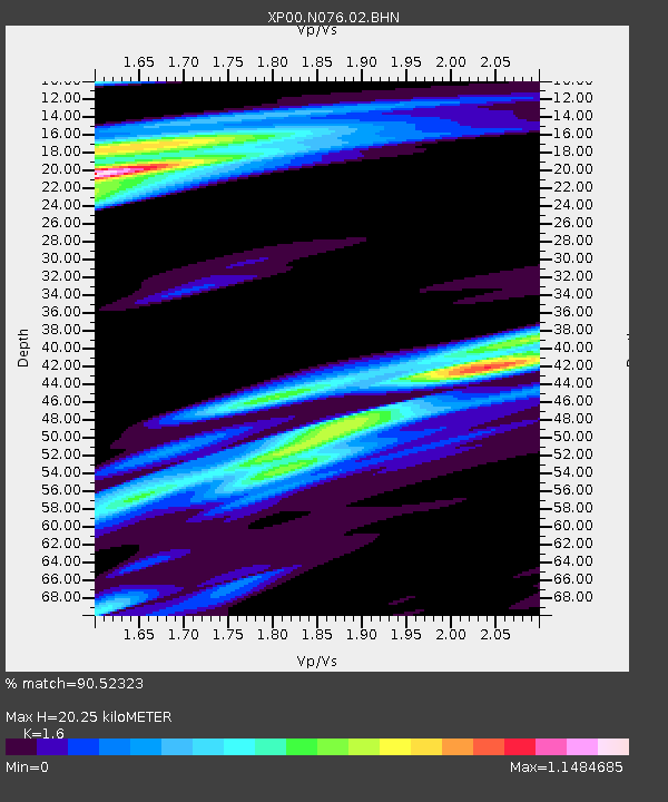
| Estimated Moho Depth: |
20.25 km |
| Estimated Crust Vp/Vs: |
1.60 |
| Assumed Crust Vp: |
6.292 km/s |
| Estimated Crust Vs: |
3.932 km/s |
| Estimated Crust Poisson's Ratio: |
0.18 |
|
| Radial Match: |
90.52323 % |
| Radial Bump: |
400 |
| Transverse Match: |
76.47101 % |
| Transverse Bump: |
400 |
| SOD ConfigId: |
16820 |
| Insert Time: |
2010-03-09 13:43:59.606 +0000 |
| GWidth: |
2.5 |
| Max Bumps: |
400 |
| Tol: |
0.001 |
|

Signal To Noise
| Channel | StoN | STA | LTA |
| XP:N076:02:BHN:20030110T13:23:05.047024Z | 3.5743353 | 1.5948817E-6 | 4.4620373E-7 |
| XP:N076:02:BHE:20030110T13:23:05.047024Z | 2.6365356 | 8.71326E-7 | 3.3048138E-7 |
| XP:N076:02:BHZ:20030110T13:23:05.047024Z | 25.032898 | 5.6658128E-6 | 2.2633468E-7 |
| Arrivals |
| Ps | 2.0 SECOND |
| PpPs | 8.1 SECOND |
| PsPs/PpSs | 10 SECOND |


