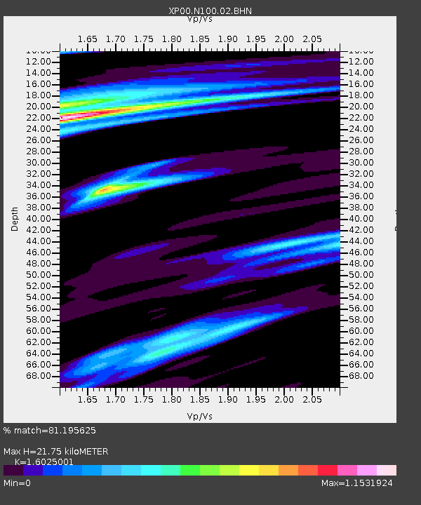
N100 N100 - Earthquake Result Viewer

Earthquake location: New Britain Region, P.N.G.
Earthquake latitude/longitude: -5.7/151.1
Earthquake time(UTC): 2002/01/13 (013) 14:10:56 GMT
Earthquake Depth: 44 km
Earthquake Magnitude: 5.9 MB, 6.4 MS, 6.3 MW, 6.3 MW
Earthquake Catalog/Contributor: WHDF/NEIC
Network: XP Trans Antarctic Mountain Seismic Experiment
Station: N100 N100
Lat/Lon: 81.65 S/122.61 E
Elevation: 2933 m
Distance: 77.0 deg
Az: 184.099 deg
Baz: 29.128 deg
Ray Param: 0.050530832
Estimated Moho Depth: 21.75 km
Estimated Crust Vp/Vs: 1.60
Assumed Crust Vp: 6.261 km/s
Estimated Crust Vs: 3.907 km/s
Estimated Crust Poisson's Ratio: 0.18
Radial Match: 81.195625 %
Radial Bump: 400
Transverse Match: 67.36367 %
Transverse Bump: 400
SOD ConfigId: 16820
Insert Time: 2010-03-09 13:44:19.956 +0000
GWidth: 2.5
Max Bumps: 400
Tol: 0.001

Signal To Noise

ChannelStoNSTALTA
XP:N100:02:BHN:20020113T14:22:13.897014Z1.29886953.252845E-72.504366E-7
XP:N100:02:BHE:20020113T14:22:13.897014Z1.25188362.0464593E-71.634704E-7
XP:N100:02:BHZ:20020113T14:22:13.897014Z11.5098711.7639536E-61.5325573E-7
Arrivals
Ps2.2 SECOND
PpPs8.8 SECOND
PsPs/PpSs11 SECOND