
Station XP N100 - N100
Network: XP00 - Trans Antarctic Mountain Seismic Experiment
Nearby stations (2 deg radius)
| Station | Name | (Lat, Lon) | Start / End | Elevation |
| N100 | N100 | (-81.65, 122.61) | 2001-12-02 / 2003-12-31 | 2.9 km |
| Crust2 Type: | F7,Archean 3.0 km ice, no seds. |
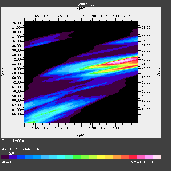
| Thickness Estimate: | 43 km |
| Thickness StdDev: | 7.2 km |
| Vp/Vs Estimate: | 2.01 |
| Vp/Vs StdDev: | 0.11 |
| Vs Estimate: | 3.115 km/s |
| Poisson's Ratio: | 0.34 |
| Peak Value: | 0.02 |
| Assumed Vp: | 6.261 km/s |
| Ps Weight: | 0.33333334 |
| PpPs Weight: | 0.33333334 |
| PsPs Weight: | 0.33333328 |
| Residual Complexity: | 0.705 |
| Nearby stations H: | +- |
| (2.0 deg) Vp/Vs: | +- |
7 with match > 90% ( 53.846153 %) and 13 with match > 80% ( 100.0 %) out of 13.
Download stack as xyz text file.
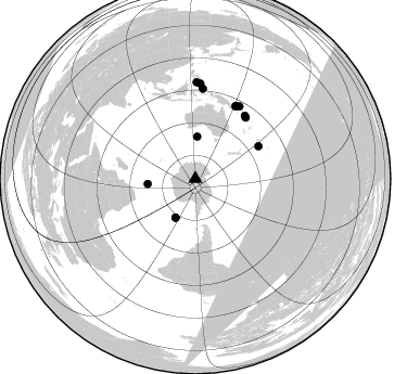
Azimuth Distribution of Events:
Prior Results for this Station
| Study | Thickness | Vp/Vs | Vp | Vs | Poissons Ratio | Extra |
| EARS | 43 km | 2.01 | 6.261 km/s | 3.115 km/s | 0.34 | |
| Crust2.0 | 40 km | 1.77 | 6.261 km/s | 3.535 km/s | 0.27 | F7,Archean 3.0 km ice, no seds. |
| Global Maxima | 43 km | 2.01 | 6.261 km/s | 3.115 km/s | 0.34 | amp=0.016791899 |
| Local Maxima 1 | 45 km | 2.07 | 6.261 km/s | 3.028 km/s | 0.35 | amp=0.013918049 |
| Local Maxima 2 | 43 km | 2.10 | 6.261 km/s | 2.985 km/s | 0.35 | amp=0.009983581 |
| Local Maxima 3 | 70 km | 1.63 | 6.261 km/s | 3.847 km/s | 0.20 | amp=0.0076197623 |
| Local Maxima 4 | 64 km | 1.73 | 6.261 km/s | 3.629 km/s | 0.25 | amp=0.0069680093 |
| Predicted Arrivals for vertical incidence (zero ray parameter) | |
| Ps | 6.90 SECOND |
| PpPs | 20.55 SECOND |
| PsPs/PpSs | 27.45 SECOND |
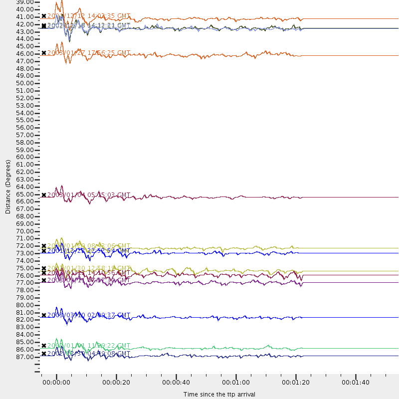
Events Processed for this Station
Download zip of receiver functions as SAC
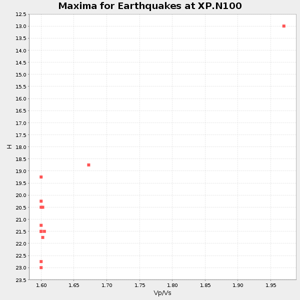
Plot maxima for each earthquake.
Events Used in the Stack
(13 events)| Radial Match | Distance | Baz | FERegion | Time | Lat/Lon | Depth | Magnitude |
| 96.71164 | 73.0 deg | 39.446 deg | Solomon Islands | 2003/01/20 08:43:06 GMT | (-10.5, 160.8) | 33 km | 6.7 MB, 7.8 MS, 7.3 MW, 7.2 MW |
| 95.69751 | 40.4 deg | 206.833 deg | South Sandwich Islands Region | 2002/12/18 14:12:21 GMT | (-57.1, -25.0) | 10 km | 5.5 MB, 6.0 MS, 6.2 MW, 5.9 MW |
| 94.875885 | 40.5 deg | 206.99 deg | South Sandwich Islands Region | 2002/12/17 04:32:53 GMT | (-57.0, -24.8) | 10 km | 5.4 MB, 6.3 MS, 6.2 MW, 6.0 MW |
| 94.71344 | 73.8 deg | 38.092 deg | Solomon Islands | 2001/12/23 22:52:54 GMT | (-9.6, 159.5) | 16 km | 6.2 MB, 7.0 MS, 6.8 MW, 6.7 MW |
| 92.48557 | 65.5 deg | 62.782 deg | Fiji Islands Region | 2003/01/04 05:15:03 GMT | (-20.6, -177.7) | 378 km | 6.0 MB, 6.5 MW, 6.5 MW |
| 92.259186 | 39.0 deg | 2.431 deg | South Of Australia | 2001/12/12 14:02:35 GMT | (-42.8, 124.7) | 10 km | 6.5 MB, 6.7 MS, 7.1 MW, 7.0 MW |
| 92.102196 | 78.1 deg | 31.257 deg | New Ireland Region, P.N.G. | 2003/03/11 07:27:32 GMT | (-4.7, 153.2) | 40 km | 6.0 MB, 6.8 MS, 6.8 MW, 6.6 MW |
| 86.64588 | 87.9 deg | 3.024 deg | Mindanao, Philippines | 2002/01/01 11:29:22 GMT | (6.3, 125.7) | 138 km | 5.9 MB, 6.3 MW, 6.3 MW |
| 85.7869 | 44.4 deg | 263.812 deg | Prince Edward Islands Region | 2003/01/27 17:56:25 GMT | (-46.0, 35.1) | 10 km | 5.6 MB, 6.3 MS, 6.5 MW, 6.4 MW |
| 85.097176 | 89.0 deg | 0.79 deg | Mindanao, Philippines | 2002/12/30 04:49:08 GMT | (7.5, 123.4) | 10 km | 5.9 MB, 6.2 MS, 6.3 MW, 6.2 MW |
| 82.35254 | 83.3 deg | 4.716 deg | Halmahera, Indonesia | 2003/03/10 02:09:37 GMT | (1.7, 127.3) | 94 km | 6.2 MB, 6.4 MW, 6.4 MW |
| 81.512276 | 76.4 deg | 28.981 deg | New Britain Region, P.N.G. | 2002/01/30 12:58:19 GMT | (-6.3, 150.9) | 33 km | 5.9 MB, 6.0 MS, 5.9 MW, 5.8 MW |
| 81.195625 | 77.0 deg | 29.128 deg | New Britain Region, P.N.G. | 2002/01/13 14:10:56 GMT | (-5.7, 151.1) | 44 km | 5.9 MB, 6.4 MS, 6.3 MW, 6.3 MW |
Losers
(0 events)| Radial Match | Distance | Baz | FERegion | Time | Lat/Lon | Depth | Magnitude | Reason |
