You are here: Home > Network List > XP00 - Trans Antarctic Mountain Seismic Experiment Stations List
> Station N100 N100 > Earthquake Result Viewer
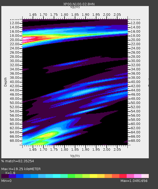
N100 N100 - Earthquake Result Viewer
| Earthquake location: |
Halmahera, Indonesia |
| Earthquake latitude/longitude: |
1.7/127.3 |
| Earthquake time(UTC): |
2003/03/10 (069) 02:09:37 GMT |
| Earthquake Depth: |
94 km |
| Earthquake Magnitude: |
6.2 MB, 6.4 MW, 6.4 MW |
| Earthquake Catalog/Contributor: |
WHDF/NEIC |
|
| Network: |
XP Trans Antarctic Mountain Seismic Experiment |
| Station: |
N100 N100 |
| Lat/Lon: |
81.65 S/122.61 E |
| Elevation: |
2933 m |
|
| Distance: |
83.3 deg |
| Az: |
180.689 deg |
| Baz: |
4.716 deg |
| Ray Param: |
0.046080455 |
| Estimated Moho Depth: |
19.25 km |
| Estimated Crust Vp/Vs: |
1.60 |
| Assumed Crust Vp: |
6.261 km/s |
| Estimated Crust Vs: |
3.913 km/s |
| Estimated Crust Poisson's Ratio: |
0.18 |
|
| Radial Match: |
82.35254 % |
| Radial Bump: |
400 |
| Transverse Match: |
52.396046 % |
| Transverse Bump: |
400 |
| SOD ConfigId: |
16820 |
| Insert Time: |
2010-03-09 13:44:25.408 +0000 |
| GWidth: |
2.5 |
| Max Bumps: |
400 |
| Tol: |
0.001 |
|

Signal To Noise
| Channel | StoN | STA | LTA |
| XP:N100:02:BHN:20030310T02:21:22.402021Z | 8.758999 | 2.0338207E-6 | 2.3219786E-7 |
| XP:N100:02:BHE:20030310T02:21:22.402021Z | 0.5778048 | 4.1609567E-7 | 7.201319E-7 |
| XP:N100:02:BHZ:20030310T02:21:22.402021Z | 11.151333 | 6.9658945E-6 | 6.246692E-7 |
| Arrivals |
| Ps | 1.9 SECOND |
| PpPs | 7.8 SECOND |
| PsPs/PpSs | 9.7 SECOND |


