You are here: Home > Network List > XP00 - Trans Antarctic Mountain Seismic Experiment Stations List
> Station N108 N108 > Earthquake Result Viewer
N108 N108 - Earthquake Result Viewer
| Earthquake location: |
New Ireland Region, P.N.G. |
| Earthquake latitude/longitude: |
-5.3/153.7 |
| Earthquake time(UTC): |
2003/01/10 (010) 13:11:56 GMT |
| Earthquake Depth: |
72 km |
| Earthquake Magnitude: |
5.9 MB, 6.7 MW, 6.6 MW |
| Earthquake Catalog/Contributor: |
WHDF/NEIC |
|
| Network: |
XP Trans Antarctic Mountain Seismic Experiment |
| Station: |
N108 N108 |
| Lat/Lon: |
81.88 S/117.61 E |
| Elevation: |
3061 m |
|
| Distance: |
78.1 deg |
| Az: |
184.91 deg |
| Baz: |
36.829 deg |
| Ray Param: |
0.049689885 |
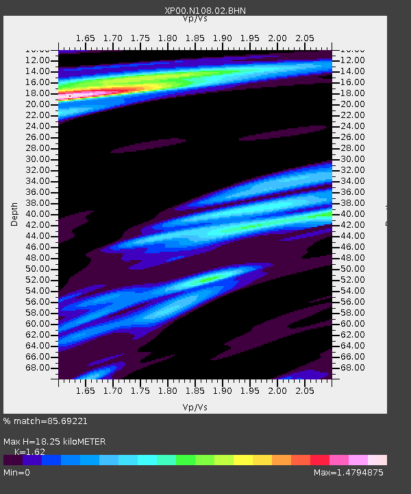
| Estimated Moho Depth: |
18.25 km |
| Estimated Crust Vp/Vs: |
1.62 |
| Assumed Crust Vp: |
6.261 km/s |
| Estimated Crust Vs: |
3.865 km/s |
| Estimated Crust Poisson's Ratio: |
0.19 |
|
| Radial Match: |
85.69221 % |
| Radial Bump: |
400 |
| Transverse Match: |
77.57832 % |
| Transverse Bump: |
400 |
| SOD ConfigId: |
16820 |
| Insert Time: |
2010-03-09 13:44:46.069 +0000 |
| GWidth: |
2.5 |
| Max Bumps: |
400 |
| Tol: |
0.001 |
|

Signal To Noise
| Channel | StoN | STA | LTA |
| XP:N108:02:BHN:20030110T13:23:17.31802Z | 5.26736 | 1.4138133E-6 | 2.6841022E-7 |
| XP:N108:02:BHE:20030110T13:23:17.31802Z | 3.5501118 | 1.2654763E-6 | 3.56461E-7 |
| XP:N108:02:BHZ:20030110T13:23:17.31802Z | 25.371494 | 5.787571E-6 | 2.2811312E-7 |
| Arrivals |
| Ps | 1.9 SECOND |
| PpPs | 7.4 SECOND |
| PsPs/PpSs | 9.3 SECOND |


