
Station XP N108 - N108
Network: XP00 - Trans Antarctic Mountain Seismic Experiment
Nearby stations (2 deg radius)
| Station | Name | (Lat, Lon) | Start / End | Elevation |
| N108 | N108 | (-81.88, 117.61) | 2001-12-03 / 2003-12-31 | 3.1 km |
| Crust2 Type: | F7,Archean 3.0 km ice, no seds. |
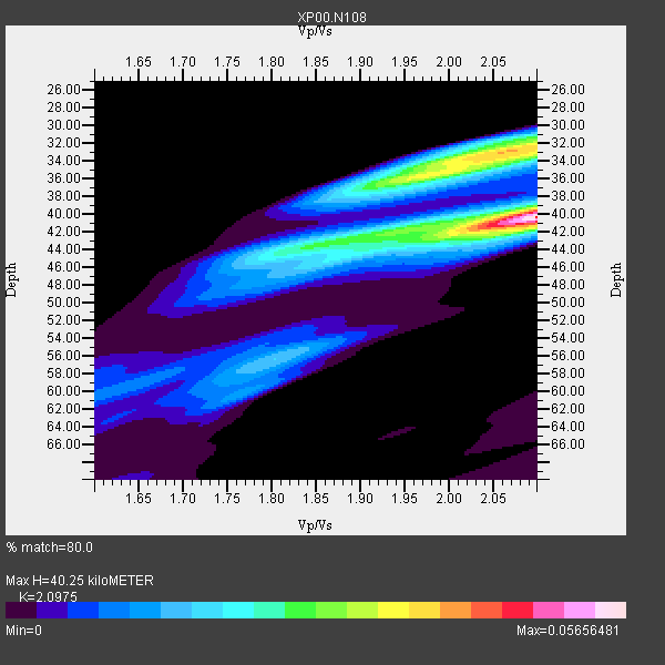
| Thickness Estimate: | 40 km |
| Thickness StdDev: | 1.3 km |
| Vp/Vs Estimate: | 2.10 |
| Vp/Vs StdDev: | 0.02 |
| Vs Estimate: | 2.985 km/s |
| Poisson's Ratio: | 0.35 |
| Peak Value: | 0.06 |
| Assumed Vp: | 6.261 km/s |
| Ps Weight: | 0.33333334 |
| PpPs Weight: | 0.33333334 |
| PsPs Weight: | 0.33333328 |
| Residual Complexity: | 0.768 |
| Nearby stations H: | +- |
| (2.0 deg) Vp/Vs: | +- |
5 with match > 90% ( 41.666668 %) and 12 with match > 80% ( 100.0 %) out of 12.
Download stack as xyz text file.
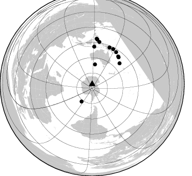
Azimuth Distribution of Events:
Prior Results for this Station
| Study | Thickness | Vp/Vs | Vp | Vs | Poissons Ratio | Extra |
| EARS | 40 km | 2.10 | 6.261 km/s | 2.985 km/s | 0.35 | |
| Crust2.0 | 40 km | 1.77 | 6.261 km/s | 3.535 km/s | 0.27 | F7,Archean 3.0 km ice, no seds. |
| Global Maxima | 40 km | 2.10 | 6.261 km/s | 2.985 km/s | 0.35 | amp=0.05656481 |
| Local Maxima 1 | 33 km | 2.07 | 6.261 km/s | 3.025 km/s | 0.35 | amp=0.03978925 |
| Local Maxima 2 | 36 km | 1.96 | 6.261 km/s | 3.194 km/s | 0.32 | amp=0.0291963 |
| Local Maxima 3 | 42 km | 2.09 | 6.261 km/s | 2.992 km/s | 0.35 | amp=0.020436771 |
| Local Maxima 4 | 41 km | 1.96 | 6.261 km/s | 3.202 km/s | 0.32 | amp=0.019784728 |
| Predicted Arrivals for vertical incidence (zero ray parameter) | |
| Ps | 7.06 SECOND |
| PpPs | 19.91 SECOND |
| PsPs/PpSs | 26.97 SECOND |
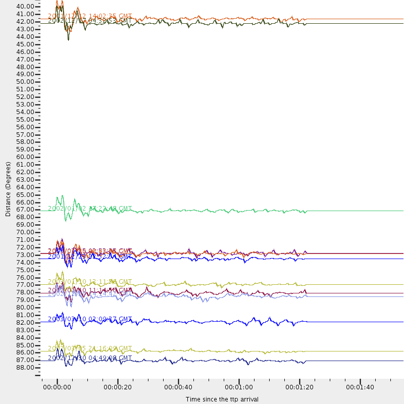
Events Processed for this Station
Download zip of receiver functions as SAC
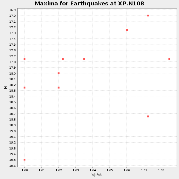
Plot maxima for each earthquake.
Events Used in the Stack
(12 events)| Radial Match | Distance | Baz | FERegion | Time | Lat/Lon | Depth | Magnitude |
| 98.895966 | 73.7 deg | 44.513 deg | Solomon Islands | 2003/01/20 08:43:06 GMT | (-10.5, 160.8) | 33 km | 6.7 MB, 7.8 MS, 7.3 MW, 7.2 MW |
| 96.71601 | 74.4 deg | 43.159 deg | Solomon Islands | 2001/12/23 22:52:54 GMT | (-9.6, 159.5) | 16 km | 6.2 MB, 7.0 MS, 6.8 MW, 6.7 MW |
| 96.47143 | 40.0 deg | 211.33 deg | South Sandwich Islands Region | 2002/12/17 04:32:53 GMT | (-57.0, -24.8) | 10 km | 5.4 MB, 6.3 MS, 6.2 MW, 6.0 MW |
| 95.98117 | 67.4 deg | 52.586 deg | Vanuatu Islands | 2002/01/02 17:22:48 GMT | (-17.6, 167.9) | 21 km | 6.3 MB, 7.5 MS, 7.3 MW, 7.1 MW |
| 91.92646 | 87.9 deg | 6.612 deg | Mindanao, Philippines | 2002/03/05 21:16:09 GMT | (6.0, 124.2) | 31 km | 6.3 MB, 7.2 MS, 7.5 MW, 7.2 MW |
| 88.86337 | 39.3 deg | 8.24 deg | South Of Australia | 2001/12/12 14:02:35 GMT | (-42.8, 124.7) | 10 km | 6.5 MB, 6.7 MS, 7.1 MW, 7.0 MW |
| 88.19489 | 73.6 deg | 3.237 deg | Flores Region, Indonesia | 2003/03/25 02:53:25 GMT | (-8.3, 120.7) | 33 km | 6.2 MB, 6.1 MS, 6.5 MW, 6.3 MW |
| 86.83627 | 83.6 deg | 9.747 deg | Halmahera, Indonesia | 2003/03/10 02:09:37 GMT | (1.7, 127.3) | 94 km | 6.2 MB, 6.4 MW, 6.4 MW |
| 85.69221 | 78.1 deg | 36.829 deg | New Ireland Region, P.N.G. | 2003/01/10 13:11:56 GMT | (-5.3, 153.7) | 72 km | 5.9 MB, 6.7 MW, 6.6 MW |
| 84.457596 | 79.4 deg | 25.241 deg | Near N Coast Of New Guinea, P.N.G. | 2002/01/10 11:14:56 GMT | (-3.2, 142.4) | 11 km | 6.0 MB, 6.6 MS, 6.7 MW, 6.6 MW |
| 84.35995 | 79.9 deg | 30.818 deg | Bismarck Sea | 2002/12/20 14:14:42 GMT | (-3.1, 147.9) | 33 km | 5.8 MB, 6.4 MS, 6.3 MW, 6.3 MW |
| 83.67517 | 89.3 deg | 5.753 deg | Mindanao, Philippines | 2002/12/30 04:49:08 GMT | (7.5, 123.4) | 10 km | 5.9 MB, 6.2 MS, 6.3 MW, 6.2 MW |
Losers
(0 events)| Radial Match | Distance | Baz | FERegion | Time | Lat/Lon | Depth | Magnitude | Reason |
