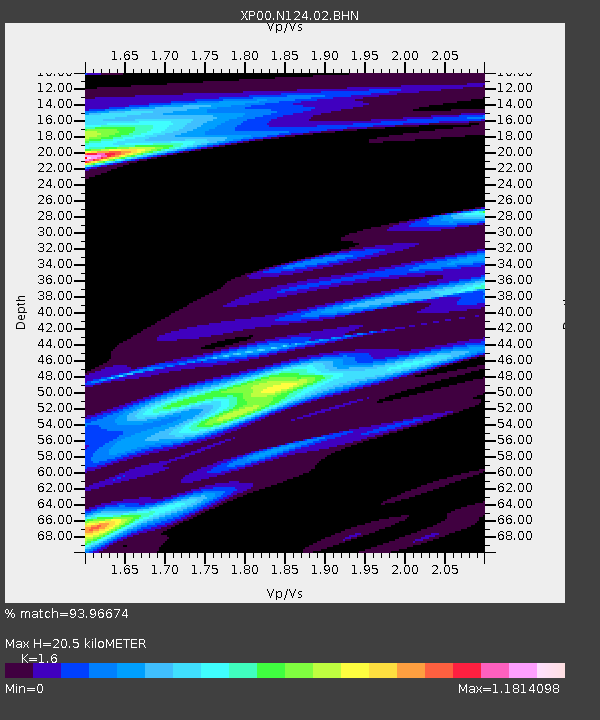
N124 N124 - Earthquake Result Viewer

Earthquake location: South Georgia Island Region
Earthquake latitude/longitude: -56.1/-36.4
Earthquake time(UTC): 2002/11/15 (319) 19:58:31 GMT
Earthquake Depth: 10 km
Earthquake Magnitude: 6.1 MB, 6.6 MS, 6.7 MW, 6.4 MW
Earthquake Catalog/Contributor: WHDF/NEIC
Network: XP Trans Antarctic Mountain Seismic Experiment
Station: N124 N124
Lat/Lon: 82.07 S/107.64 E
Elevation: 3334 m
Distance: 40.8 deg
Az: 172.839 deg
Baz: 210.258 deg
Ray Param: 0.074173525
Estimated Moho Depth: 20.5 km
Estimated Crust Vp/Vs: 1.60
Assumed Crust Vp: 6.261 km/s
Estimated Crust Vs: 3.913 km/s
Estimated Crust Poisson's Ratio: 0.18
Radial Match: 93.96674 %
Radial Bump: 400
Transverse Match: 87.180664 %
Transverse Bump: 400
SOD ConfigId: 16820
Insert Time: 2010-03-09 13:44:59.911 +0000
GWidth: 2.5
Max Bumps: 400
Tol: 0.001

Signal To Noise

ChannelStoNSTALTA
XP:N124:02:BHN:20021115T20:05:42.54001Z1.55216542.004631E-71.291506E-7
XP:N124:02:BHE:20021115T20:05:42.54001Z1.5042791.926511E-71.2806873E-7
XP:N124:02:BHZ:20021115T20:05:42.54001Z1.19518911.7942708E-71.5012442E-7
Arrivals
Ps2.1 SECOND
PpPs7.9 SECOND
PsPs/PpSs10 SECOND