
Station XP N124 - N124
Network: XP00 - Trans Antarctic Mountain Seismic Experiment
Nearby stations (2 deg radius)
| Station | Name | (Lat, Lon) | Start / End | Elevation |
| N124 | N124 | (-82.07, 107.64) | 2001-12-08 / 2003-12-31 | 3.3 km |
| Crust2 Type: | F7,Archean 3.0 km ice, no seds. |
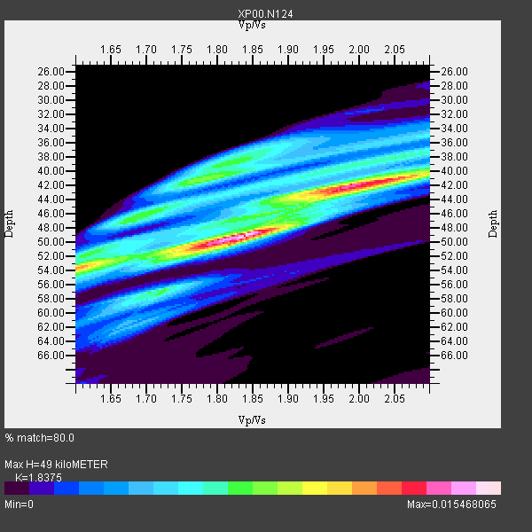
| Thickness Estimate: | 49 km |
| Thickness StdDev: | 5.4 km |
| Vp/Vs Estimate: | 1.84 |
| Vp/Vs StdDev: | 0.11 |
| Vs Estimate: | 3.407 km/s |
| Poisson's Ratio: | 0.29 |
| Peak Value: | 0.02 |
| Assumed Vp: | 6.261 km/s |
| Ps Weight: | 0.33333334 |
| PpPs Weight: | 0.33333334 |
| PsPs Weight: | 0.33333328 |
| Residual Complexity: | 0.769 |
| Nearby stations H: | +- |
| (2.0 deg) Vp/Vs: | +- |
8 with match > 90% ( 66.666664 %) and 12 with match > 80% ( 100.0 %) out of 12.
Download stack as xyz text file.
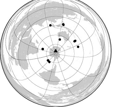
Azimuth Distribution of Events:
Prior Results for this Station
| Study | Thickness | Vp/Vs | Vp | Vs | Poissons Ratio | Extra |
| EARS | 49 km | 1.84 | 6.261 km/s | 3.407 km/s | 0.29 | |
| Crust2.0 | 40 km | 1.77 | 6.261 km/s | 3.535 km/s | 0.27 | F7,Archean 3.0 km ice, no seds. |
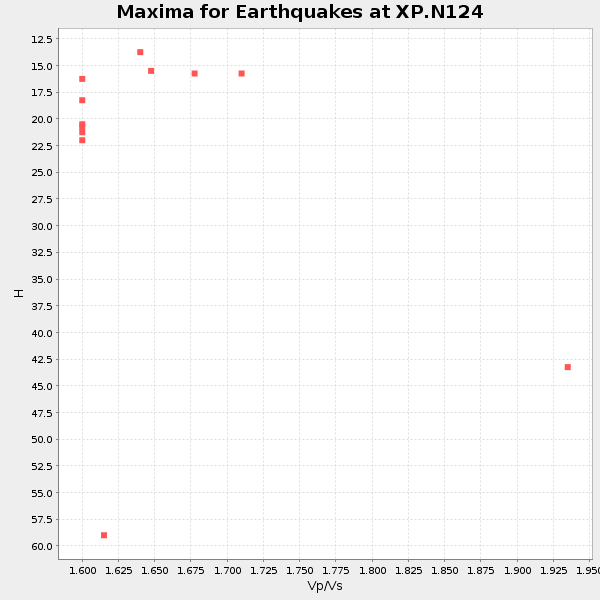
| Global Maxima | 49 km | 1.84 | 6.261 km/s | 3.407 km/s | 0.29 | amp=0.015468065 |
| Local Maxima 1 | 41 km | 2.04 | 6.261 km/s | 3.077 km/s | 0.34 | amp=0.011637635 |
| Local Maxima 2 | 41 km | 1.78 | 6.261 km/s | 3.522 km/s | 0.27 | amp=0.008402972 |
| Local Maxima 3 | 54 km | 1.60 | 6.261 km/s | 3.907 km/s | 0.18 | amp=0.0076528084 |
| Local Maxima 4 | 38 km | 1.83 | 6.261 km/s | 3.431 km/s | 0.29 | amp=0.005983548 |
| Predicted Arrivals for vertical incidence (zero ray parameter) | |
| Ps | 6.55 SECOND |
| PpPs | 22.21 SECOND |
| PsPs/PpSs | 28.76 SECOND |
Events Processed for this Station
Download zip of receiver functions as SAC
Plot maxima for each earthquake.
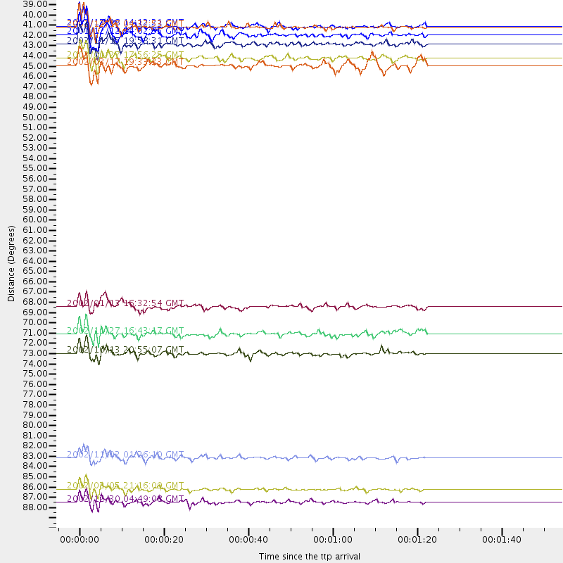
Events Used in the Stack
(12 events)| Radial Match | Distance | Baz | FERegion | Time | Lat/Lon | Depth | Magnitude |
| 96.13467 | 85.0 deg | 348.412 deg | Northern Sumatra, Indonesia | 2002/11/02 01:26:10 GMT | (2.8, 96.1) | 30 km | 6.2 MB, 7.6 MS, 7.4 MW, 7.4 MW |
| 95.866646 | 88.3 deg | 16.52 deg | Mindanao, Philippines | 2002/03/05 21:16:09 GMT | (6.0, 124.2) | 31 km | 6.3 MB, 7.2 MS, 7.5 MW, 7.2 MW |
| 95.824 | 39.0 deg | 219.954 deg | South Sandwich Islands Region | 2002/12/17 04:32:53 GMT | (-57.0, -24.8) | 10 km | 5.4 MB, 6.3 MS, 6.2 MW, 6.0 MW |
| 94.183235 | 38.9 deg | 219.783 deg | South Sandwich Islands Region | 2002/12/18 14:12:21 GMT | (-57.1, -25.0) | 10 km | 5.5 MB, 6.0 MS, 6.2 MW, 5.9 MW |
| 93.96674 | 40.8 deg | 210.258 deg | South Georgia Island Region | 2002/11/15 19:58:31 GMT | (-56.1, -36.4) | 10 km | 6.1 MB, 6.6 MS, 6.7 MW, 6.4 MW |
| 93.38429 | 73.8 deg | 79.085 deg | Samoa Islands Region | 2002/10/13 20:55:07 GMT | (-14.6, -175.4) | 10 km | 5.8 MB, 6.0 MS, 6.1 MW, 6.0 MW |
| 92.414085 | 42.3 deg | 279.132 deg | Prince Edward Islands Region | 2003/01/27 17:56:25 GMT | (-46.0, 35.1) | 10 km | 5.6 MB, 6.3 MS, 6.5 MW, 6.4 MW |
| 90.30362 | 89.7 deg | 15.629 deg | Mindanao, Philippines | 2002/12/30 04:49:08 GMT | (7.5, 123.4) | 10 km | 5.9 MB, 6.2 MS, 6.3 MW, 6.2 MW |
| 87.873924 | 39.8 deg | 19.691 deg | South Of Australia | 2001/12/12 14:02:35 GMT | (-42.8, 124.7) | 10 km | 6.5 MB, 6.7 MS, 7.1 MW, 7.0 MW |
| 87.39976 | 71.8 deg | 62.235 deg | Vanuatu Islands | 2002/11/27 16:43:17 GMT | (-14.5, 167.8) | 33 km | 5.6 MB, 5.8 MS, 5.9 MW, 5.8 MW |
| 82.3301 | 68.8 deg | 62.616 deg | Vanuatu Islands | 2002/01/13 16:32:54 GMT | (-17.4, 167.8) | 10 km | 5.3 MB, 5.8 MS, 5.9 MW |
| 81.7947 | 43.1 deg | 279.419 deg | Prince Edward Islands Region | 2002/03/17 19:33:33 GMT | (-45.2, 35.1) | 10 km | 5.5 MB, 5.7 MS, 6.0 MW, 6.0 MW |
Losers
(0 events)| Radial Match | Distance | Baz | FERegion | Time | Lat/Lon | Depth | Magnitude | Reason |
